
Thomas Guide is a series of paperback, spiral-bound atlases featuring detailed street maps of various large metropolitan areas in the United States, including Boise, Las Vegas, Los Angeles, Oakland, Phoenix, Portland, Reno-Tahoe, Sacramento, San Francisco, Seattle, Tucson, and Baltimore-Washington metropolitan area. Road Atlas titles are Arizona including Las Vegas, California Including portions of Nevada, and Pacific Northwest covering Washington, Oregon, Western Idaho, Southwestern British Columbia. The map books are usually arranged by county; for example, separate Thomas Guides have been published for Los Angeles County and San Diego County. There are also guides that will have two or three counties combined, or guides that cover a metropolitan area. Each guide has a detailed index of streets and points of interest, as well as arterial maps for easy page location.
MapQuest is an American free online web mapping service. It was launched in 1996 as the first commercial web mapping service. MapQuest vies for market share with competitors such as Apple Maps, Here and Google Maps.
Rand McNally is an American technology and publishing company that provides mapping, software and hardware for consumer electronics, commercial transportation and education markets. The company is headquartered in Chicago, Illinois, with a distribution center in Richmond, Kentucky.

New York State Route 440 (NY 440) is a freeway located entirely on Staten Island in New York City. The route acts as a connector between the two segments of New Jersey Route 440, running from the Staten Island community of Richmond Valley in the south to Port Richmond in the north. NY 440 is connected to the two New Jersey segments by the Outerbridge Crossing to the south and the Bayonne Bridge to the north. It is one of several signed New York State routes that are not connected to any others in the state, and one of only two New York State routes that is the middle section of another state's highway bearing the same number. From the Korean War Veterans Parkway to I-278, it is known as the West Shore Expressway. North of I-278, it is named the Dr. Martin Luther King Jr. Expressway. NY 440 is the southernmost state route in the state of New York.
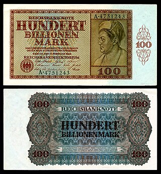
The Papiermark was the German currency from 4 August 1914 when the link between the Goldmark and gold was abandoned, due to the outbreak of World War I. In particular, the Papiermark was the currency issued during the hyperinflation in Germany of 1922 and 1923.
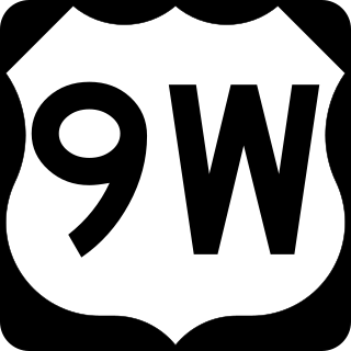
U.S. Route 9W (US 9W) is a north–south United States Numbered Highway in the states of New Jersey and New York. It begins in Fort Lee, New Jersey, as Fletcher Avenue crosses the US 1/9, US 46, and Interstate 95 (I-95) approaches to the George Washington Bridge, and heads north up the west side of the Hudson River to US 9 in Albany, New York. As its "W" suffix indicates, US 9W is a westerly alternate route of US 9 between the two locations. US 9W directly serves three cities—Newburgh, Kingston, and Albany—and enters the vicinity of several others. As the route heads north, it connects to several highways of regional importance, including I-84, US 209, New York State Route 23 (NY 23), and US 20. Much of US 9W parallels the New York State Thruway and NY 32; additionally, the latter overlaps with US 9W in four different locations.

New York State Route 27 (NY 27) is a 120.58-mile (194.05 km) long state highway that runs east–west from Interstate 278 (I-278) in the New York City borough of Brooklyn to Montauk Point State Park on Long Island, New York. Its two most prominent components are Sunrise Highway and Montauk Highway, the latter of which includes the Montauk Point State Parkway. NY 27 acts as the primary east–west highway on southern Long Island east of the interchange with the Heckscher State Parkway in Islip Terrace. The entire route in Suffolk, Nassau, and Queens counties were designated by the New York State Senate as the POW/MIA Memorial Highway. The highway gives access to every town on the South Shore. NY 27 is the easternmost state route in the state of New York, as well as the longest highway on Long Island.

New York State Route 132 (NY 132) is a 2.75-mile (4.43 km) state highway located entirely within the town of Yorktown in Westchester County, New York, in the United States. The route acts as a connector between the concurrency of U.S. Route 202 (US 202) and NY 35 in the south and US 6 in the hamlet of Shrub Oak in the north. When the route was assigned as part of the 1930 renumbering of state highways in New York, it continued southeast to the hamlet of Katonah. It was cut back to its current southern terminus in the early 1940s and extended one block northward to its present length between 1968 and 1973.
The H.M. Gousha Company was one of the "Big Three" major producers of road maps and atlases in the United States during the 25 years following World War II, making maps for free distribution by oil companies and auto clubs. Following the end of the free-road-map era, Gousha distributed maps through retailers, and published a number of travel guides and other travel-related books.

New York State Route 43 (NY 43) is a state highway in Rensselaer County, New York, in the United States. It extends for 24.00 miles (38.62 km) from Interstate 90 (I-90) exit 8 in North Greenbush to the Massachusetts state line, where it continues into Williamstown as Massachusetts Route 43. Most of NY 43 is a two-lane highway that passes through a mixture of rural and residential areas; however, its westernmost mile is a four-lane freeway. NY 43 has an overlap with NY 66 in Sand Lake and intersects NY 22 in Stephentown.
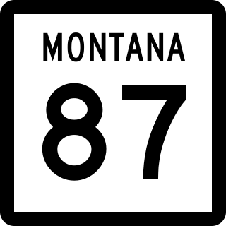
Montana Highway 87 (MT 87) is a primary state highway in Madison County in Montana, United States. The highway travels through mainly rural areas in Raynolds Pass, from the Montana–Idaho state line to an intersection with U.S. Route 287 (US 287). The route travels through a portion of Gallatin National Forest. In 1922, a road in the location of MT 87 was added to the highway system, and a few years later the road was designated as portions of two early auto trails. In 1959, the route was rapidly improved due to the collapse of US 287 nearby. During 1967, much of the highway was reconstructed along its current location.

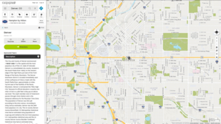
A road map, route map, or street map is a map that primarily displays roads and transport links rather than natural geographical information. It is a type of navigational map that commonly includes political boundaries and labels, making it also a type of political map. In addition to roads and boundaries, road maps often include points of interest, such as prominent businesses or buildings, tourism sites, parks and recreational facilities, hotels and restaurants, as well as airports and train stations. A road map may also document non-automotive transit routes, although often these are found only on transit maps.

K-33 is an approximately 10.4-mile-long (16.7 km) north–south state highway in the U.S. state of Kansas. K-33's southern terminus is at K-68 in rural Franklin County east of Ottawa and the northern terminus is at U.S. Route 56 (US-56) in Douglas County, east of Baldwin City and southwest of Kansas City. K-33 provides an important link between US-56 and K-68 to Interstate 35 (I-35) and US-50 in Wellsville. K-33 is a two-lane rural highway for most of its length, except for the section within Wellsville.

Several special routes of U.S. Route 40 exist. In order from west to east they are as follows.

K-20 is a 37.21-mile-long (59.88 km) west–east state highway in the northeastern part of the U.S. state of Kansas. It connects U.S. Route 75 (US-75) in the Kickapoo Nation Indian Reservation with K-7 southwest of Troy. Along the way, K-20 intersects several major highways, including U.S. Route 159 in Horton, and overlaps U.S. Route 73 from Horton to south of Everest. Northeast of Denton, the highway intersects K-120, which travels north to Severance and Highland. K-20 travels through mostly rural farmlands and is a two-lane highway its entire length.