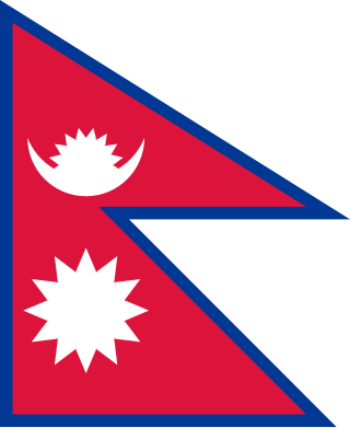
The national flag of Nepal is the world's only non-rectangular flag which is used as both the state and civil flag of a sovereign country. The flag is a simplified combination of two single pennants, known as a double-pennon. Its crimson red is the symbol of bravery and it also represents the color of the rhododendron, Nepal's national flower, while the blue border is the color of peace. Until 1962, the flag's emblems, both the sun and the crescent moon, had human faces, but they were removed to modernize the flag.

The Kingdom of Nepal was a Hindu kingdom in South Asia, formed in 1768 by the expansion of the Gorkha Kingdom, which lasted until 2008 when the kingdom became the Federal Democratic Republic of Nepal. It was also known as the Gorkha Empire, or sometimes Asal Hindustan. Founded by King Prithvi Narayan Shah, a Gorkha monarch who claimed to be of Thakuri origin from chaubisi, it existed for 240 years until the abolition of the Nepalese monarchy in 2008. During this period, Nepal was formally under the rule of the Shah dynasty, which exercised varying degrees of power during the kingdom's existence.

Nepal, officially the Federal Democratic Republic of Nepal, is a landlocked country in South Asia. It is mainly situated in the Himalayas, but also includes parts of the Indo-Gangetic Plain. It borders the Tibet Autonomous Region of China to the north, and India to the south, east, and west, while it is narrowly separated from Bangladesh by the Siliguri Corridor, and from Bhutan by the Indian state of Sikkim. Nepal has a diverse geography, including fertile plains, subalpine forested hills, and eight of the world's ten tallest mountains, including Mount Everest, the highest point on Earth. Kathmandu is the nation's capital and the largest city. Nepal is a multi-ethnic, multi-lingual, multi-religious and multi-cultural state, with Nepali as the official language.

The unification of Nepal was the process of building the modern Nepalese state, from fractured petty kingdoms including the Baise Rajya and the Chaubisi Rajya, which began in 1743 AD. The prominent figure in the unification campaign was Prithvi Narayan Shah, King of Gorkha. On 25 September 1768, he officially announced the creation of the Kingdom of Nepal and moved his capital from Gorkha to the city of Kathmandu.

The House of Representatives, commonly known as Pratinidhi Sabha, is one of the houses of the Federal Parliament of Nepal, with the other house being the National Assembly. Members of the House of Representatives are elected through a parallel voting system. They hold their seats for five years or until the body is dissolved by the President on the advice of the council of ministers. The house meets at the International Convention Centre in Kathmandu.

Baglung is a municipality in Gandaki Province, in western Nepal, 275 km (171 mi) west of Kathmandu. It is the administrative headquarters of Baglung District. Baglung serves as the major center for business, finance, education, service and healthcare for the people of mid-Kali Gandaki valley that encompass Beni, Jaljala, Baglung, Kushma, Kathekhola, Galkot, Phalewas and Jaimuni local bodies. The city is located at the cross-section of Kaligandaki corridor highway and midhill highway that transverse Nepal in north–south and east–west directions respectively.

The emblem of Nepal is used by the Government of Nepal and many government agencies. On 13 June 2020, the emblem was revised to include the newly issued map which includes Nepalese claims to the Kalapani territory and Lipulekh Pass.

Thapa (pronunciation:[t̪ʰapa]) is an Indo-Aryan surname belonging to the Chhetri/Rajput caste (Kshatriya) in Nepal and parts of Northern India.[2][3] It is also used by the Magar tribes, a Sino-Tibetan speaking ethnicity.

Nepali are the citizens of Nepal under Nepali nationality law. The term Nepali usually refers to the nationality, that is, to people with citizenship of Nepal, while the people without Nepalese citizenship but with roots in Nepal are strictly referred to as Nepali-language Speaking Foreigners who are speakers of Nepali or any of the other 128 Nepali languages but are now foreign citizens or of foreign nationality bearing passports and citizenship of the foreign nation. It is also not generally used to refer to non-citizen residents, dual citizens, and expatriates.

Chaubisi Rajya, Chaubise Rajya or Chaubisye Rajya, were sovereign and intermittently allied petty kingdoms ruled by the Magar and Thakuri kings located at the intersection of Himalayas and the Indian subcontinent. One of these kingdoms, Gorkha, annexed the others, becoming the present-day country of Nepal. This conquest began soon after Prithvi Narayan Shah ascended to the Gorkha throne in 1743 AD. The Chaubisi Rajya were annexed during the unification of Nepal from 1744 to 1816 AD. A parallel group of 22 small kingdoms, Baisse Rajya, existed to the west of the Gandaki Basin.
Hatiya is a Village Development Committee in Baglung District in the Dhaulagiri Zone of central Nepal. At the time of the 1991 Nepal census it had a population of 6,015 and had 1131 houses in the town.

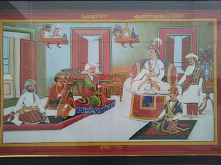
The King of Nepal was Nepal's head of state and monarch from 1768 to 2008. He served as the head of the Nepalese monarchy—Shah Dynasty. The monarchy was abolished on 28 May 2008 by the 1st Constituent Assembly. The subnational monarchies in Mustang, Bajhang, Salyan, and Jajarkot were abolished in October of the same year.

Khasa-Malla kingdom, popularly known as Khasa Kingdom and Yatse in Tibetan, was a medieval kingdom established around the 11th century in regions that are presently in far-western Nepal and parts of Uttarakhand state in India.

Nepali is an Indo-Aryan language native to the Himalayas region of South Asia. It is the official, and most widely spoken, language of Nepal, where it also serves as a lingua franca. Nepali has official status in the Indian state of Sikkim and in the Gorkhaland Territorial Administration of West Bengal. It is spoken by about a quarter of Bhutan's population. Nepali also has a significant number of speakers in the states of Arunachal Pradesh, Assam, Himachal Pradesh, Manipur, Meghalaya, Mizoram and Uttarakhand. In Myanmar it is spoken by the Burmese Gurkhas. The Nepali diaspora in the Middle East, Brunei, Australia and worldwide also use the language. Nepali is spoken by approximately 19 million native speakers and another 14 million as a second language.
The Thakuri is a Royal caste forming the core of the ruling class in Nepal. This term is a Nepali adaptation of the Indian title Thakur, which translates to 'master of the estate'. The term denotes the royal descendants of kings of Khasa Kingdom, Gandaki kingdom and the Kingdom of Nepal.

Bagale Thapa anciently known as Bagalya Thapa is a prominent clan within Khas Chhetri community. They claim Atreya Gotra. The name of the clan is also transliterated as Bagale, Bagalya, Bagaalya, Bagaliya, Bagaley, Bagaale or Bagaleya.

A municipality in Nepal is an administrative division in the Provinces of Nepal. The urban population of Nepal refers to the inhabitants residing in the designated municipal area. Population size has been taken as the principal criteria in the declaration of urban areas in Nepal since 1961. Municipalities can therefore also include rural areas. It functions as a sub-unit of a district. Nepal currently has 293 municipalities, which given the 2011 population estimate of 16,656,057.
Jaimini is a municipality in Baglung district of Gandaki province of Nepal. Nearby cities include Kusma and Baglung. Its geographic coordinates are 28.182101" N 83.613602" E. Jaimini Municipality is surrounded by Parbat district on the east, Galkot Municipality and Bareng Rural Municipality on the west, Khathekhola Rural Municipality and Baglung Municipality on the north and Gulmi and Parbat districts on the south. The population of the municipality declined to 24,628 at the 2021 Nepal census. 100% of the residents were Nepali citizens, of which 78.9% were literate.

Baglung 2 one of two parliamentary constituencies of Baglung District in Nepal. This constituency came into existence on the Constituency Delimitation Commission (CDC) report submitted on 31 August 2017.

Thirbam Malla was a Nepalese democracy activist.


