The Divide's extent

The Divide runs from (west to east) from Big Baldy west of Mount Silliman east to Triple Divide Peak, which is part of the Great Western Divide.


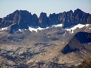
The Kings-Kaweah Divide is a divide in Sequoia National Park. It splits the watersheds of the Kaweah Rivers and the Kings River.
The Divide runs from (west to east) from Big Baldy west of Mount Silliman east to Triple Divide Peak, which is part of the Great Western Divide.
The Divide forms the northern border between Sequoia and Kings Canyon National Parks.
Going west to east, Mount Silliman is a prominent summit, as are Elizabeth Peak and Alta Peak, and the Divide terminates at Triple Divide Peak.
Both Elizabeth Pass and Copper Mine Pass are directly on the Divide, as is Silliman Pass.
It also runs along Copper Mine Pass, and is near Cloud Canyon and Upper Big Bird Lake.
| | This Tulare County, California-related article is a stub. You can help Wikipedia by expanding it. |

The Sierra Nevada is a mountain range in the Western United States, between the Central Valley of California and the Great Basin. The vast majority of the range lies in the state of California, although the Carson Range spur lies primarily in Nevada. The Sierra Nevada is part of the American Cordillera, an almost continuous chain of mountain ranges that forms the western "backbone" of the Americas.

Kings Canyon National Park is an American national park in the southern Sierra Nevada, in Fresno and Tulare Counties, California. Originally established in 1890 as General Grant National Park, the park was greatly expanded and renamed on March 4, 1940. The park's namesake, Kings Canyon, is a rugged glacier-carved valley more than a mile (1,600 m) deep. Other natural features include multiple 14,000-foot (4,300 m) peaks, high mountain meadows, swift-flowing rivers, and some of the world's largest stands of giant sequoia trees. Kings Canyon is north of and contiguous with Sequoia National Park, and both parks are jointly administered by the National Park Service as the Sequoia and Kings Canyon National Parks.

Sequoia National Park is an American national park in the southern Sierra Nevada east of Visalia, California. The park was established on September 25, 1890, and today protects 404,064 acres of forested mountainous terrain. Encompassing a vertical relief of nearly 13,000 feet (4,000 m), the park contains the highest point in the contiguous United States, Mount Whitney, at 14,505 feet (4,421 m) above sea level. The park is south of, and contiguous with, Kings Canyon National Park; both parks are administered by the National Park Service together as the Sequoia and Kings Canyon National Parks. UNESCO designated the areas as Sequoia-Kings Canyon Biosphere Reserve in 1976.

General Grant Grove, a section of the greater Kings Canyon National Park, was established by the U.S. Congress in 1890 and is located in Fresno County, California. The primary attraction of General Grant Grove is the giant sequoia trees that populate the grove. General Grant Grove's most well-known tree is called General Grant, which is 267 ft (81 m) tall and the third-largest known tree in the world. The General Grant tree is over 1,500 years old and is known as the United States' national Christmas tree. General Grant Grove consists of 154 acres (0.62 km2) and is geographically isolated from the rest of Kings Canyon National Park.

Mineral King is a subalpine glacial valley located in the southern part of Sequoia National Park, in the U.S. state of California. The valley lies at the headwaters of the East Fork of the Kaweah River, which rises at the eastern part of the valley and flows northwest. Accessed by a long and narrow winding road, the valley is mostly popular with backpackers and hikers.
Kaweah Peaks Ridge is a spur of the Great Western Divide, a sub-range of California's Sierra Nevada. The ridge is located in Sequoia National Park and is composed of mostly rugged and loose metamorphic rock.

Mount Kaweah is a mountain in California's Sequoia National Park and forms part of the Kaweah Peaks Ridge, a spur of the Great Western Divide which extends south from Triple Divide Peak. It has a summit elevation of 13,807 ft (4,208 m), the highest along the Kaweah Peaks Ridge.

The High Sierra Trail (HST) is a hiking trail in Sequoia National Park, California. The trail crosses the Sierra Nevada from west to east. According to the Yosemite Decimal System, the HST is a Class 1/Class 2 trail, which means simple scrambling, with the possibility of occasional use of the hands for balance.

The Kaweah River is a river draining the southern Sierra Nevada in Tulare County, California in the United States. Fed primarily by high elevation snowmelt along the Great Western Divide, the Kaweah begins as four forks in Sequoia National Park, where the watershed is noted for its alpine scenery and its dense concentrations of giant sequoias, the largest trees on Earth. It then flows in a southwest direction to Lake Kaweah – the only major reservoir on the river – and into the San Joaquin Valley, where it diverges into multiple channels across an alluvial plain around Visalia. With its Middle Fork headwaters starting at almost 13,000 feet (4,000 m) above sea level, the river has a vertical drop of nearly two and a half miles (4.0 km) on its short run to the San Joaquin Valley, making it one of the steepest river drainages in the United States. Although the main stem of the Kaweah is only 33.6 miles (54.1 km) long, its total length including headwaters and lower branches is nearly 100 miles (160 km).

The Great Western Divide is a Sierra Nevada mountain range that forms part of the border between the Kings Canyon and Sequoia National Parks. Some of the summits of the Great Western Divide reach well over 13,000 feet (3,962 m). The High Sierra Trail crosses the range at Kaweah Gap from Sequoia National Park.

Jennie Lakes Wilderness is a protected area in the Sierra Nevada, in Tulare County, California. It is located 60 miles (97 km) east of Fresno and managed by the US Forest Service. Jennie Lakes Wilderness is about nine square miles within the Sequoia National Forest, that was established by the California Wilderness Act of 1984, and added to the National Wilderness Preservation System.

The Kaweah Gap is the lowest east–west pass through the Great Western Divide, in Sequoia National Park, California, United States. The High Sierra Trail is routed through this pass.
Triple Divide Peak is a mountain along the Great Western Divide in the Sierra Nevada range on the boundary between Kings Canyon and Sequoia national parks, in Tulare County, California. It rises to 12,640 feet (3,853 m).
The Monarch Wilderness is a federally designated wilderness area located 70 miles east of Fresno, California, in the Sierra Nevada mountain range. It encompasses 44,896 acres (181.69 km2) within both the Sequoia National Forest and the Sierra National Forest and is managed by the United States Forest Service. Elevations range from 950 feet (290 m) to 11,081 ft (3,377 m).

Mount Silliman is a mountain in California along the boundary between Sequoia National Park and Kings Canyon National Park The summit, at 11,193 feet (3,412 m) is on the Sillman Crest, a part of the Kings-Kaweah Divide.
Silliman Pass is a mountain pass on the border of Sequoia National Park and Kings Canyon National Park.

Twin Peaks is a double summit, in Sequoia National Park, California, United States. The highest has an elevation of 10,463 feet (3,189 m).

Mount Eisen is a 12,185-foot-elevation (3,714-meter) double summit mountain located on the Great Western Divide of the Sierra Nevada mountain range, in Tulare County of northern California. It is situated in Sequoia National Park, 1.6 miles (2.6 km) south of Lippincott Mountain. Mount Eisen ranks as the 380th highest summit in California. Topographic relief is significant as the south aspect rises 3,500 feet above Pinto Lake in one mile. The summit can be reached from the southeast ridge via a long class 2 hike from Black Rock Pass.

Picket Guard Peak is a 12,302-foot-elevation (3,750 meter) mountain summit located west of the crest of the Sierra Nevada mountain range in Tulare County, California. It is situated in Sequoia National Park, two miles southwest of Kern Point, 3.4 miles (5.5 km) north of Mount Kaweah, and three miles east of the junction of Kaweah Peaks Ridge with Great Western Divide. Picket Guard Peak ranks as the 345th-highest summit in California, and topographic relief is significant as the summit rises 4,265 feet above Kern Canyon in approximately three miles.