Kings Walk Shopping Centre, Gloucester

Last updated
Kings Walk Shopping Centre
Kings Walk Shopping Centre (7).jpg
Location Gloucester, England
Coordinates 51°51′53″N2°14′42″W / 51.8646334°N 2.24505711°W / 51.8646334; -2.24505711 Coordinates: 51°51′53″N2°14′42″W / 51.8646334°N 2.24505711°W / 51.8646334; -2.24505711
Address 37-41 Clarence Street, Gloucester GL1 1EA.
Opening date 1969 - 1972
Developer Gloucester City Council (Land), Aviva Investors (Shops)
Owner Reef Estates
No. of stores and services 29
No. of floors 1
Parking 290 spaces (16 Disabled spaces) [1]
Website Official site

Kings Walk Shopping Centre is a single-storey indoor shopping centre in Gloucester, England. Built between 1969 and 1972, [2] it is part of the Kings Quarter development that includes an outdoor pedestrianised area. [3] [4]

Gloucester City and Non-metropolitan district in England

Gloucester is a city and district in Gloucestershire, in the South West of England, of which it is the county town. Gloucester lies close to the Welsh border, on the River Severn, between the Cotswolds to the east and the Forest of Dean to the southwest.

England Country in north-west Europe, part of the United Kingdom

England is a country that is part of the United Kingdom. It shares land borders with Wales to the west and Scotland to the north-northwest. The Irish Sea lies west of England and the Celtic Sea lies to the southwest. England is separated from continental Europe by the North Sea to the east and the English Channel to the south. The country covers five-eighths of the island of Great Britain, which lies in the North Atlantic, and includes over 100 smaller islands, such as the Isles of Scilly and the Isle of Wight.

Contents

View of Kings Walk Shopping Centre, towards Eastgate Street Kings Walk Shopping Centre.jpg
View of Kings Walk Shopping Centre, towards Eastgate Street

History

Before it became a shopping centre, it was called Kings Street. This was primarily an industrial area and included a factory, which was built in 1873, for the printer John Bellows. This area was gradually commercialised with a lot of rebuilding done after the first world war between the 1920s and the 1930s. The north part of Kings Street was demolished in the 1920s when Kings Square was built. [5] One of the largest commercial developments took place between 1927 and 1929 and involved the creation of The Oxbode and Kings Square. It also involved the demolition of the many buildings in St Aldate Street, Kings Street and New Inn Lane, making room for new commercial buildings. Kings Square was enlarged in the 1960s and the space was made for the Kings Walk Shopping Centre to be developed. [3] In a large redevelopment of central Gloucester between 1969 and 1972 which involved Kings Street, Kings Square, Dog Lane and Clarence Street, shops were built on both sides of Kings Street and it was covered becoming pedestrianised indoor area called Kings Walk. [4] Eastgate House, an Adamish stone fronted building, was demolished when the shopping centre was developed. [6] A rooftop car park was built over the shopping centre. A pedestrian footbridge on the second floor spanned over Eastgate Street to link the Eastgate Shopping Centre and Kings Walk however, this has now been closed off. [7]

John Thomas Bellows was a polymath, printer and lexicographer, originally from Cornwall in southwest England. He wrote prolifically.

Kings Square, Gloucester

Kings Square is a market square in Gloucester, England connecting to Kings Walk Shopping Centre, Market Parade, The Oxbode and St Aldate Street.

Robert Adam Scottish neoclassical architect

Robert Adam was a Scottish neoclassical architect, interior designer and furniture designer. He was the son of William Adam (1689–1748), Scotland's foremost architect of the time, and trained under him. With his older brother John, Robert took on the family business, which included lucrative work for the Board of Ordnance, after William's death.

In June 2016, the investment firm Vixcroft made a bid to buy the shopping centre from Aviva Investors, who have owned the shopping centre since 1969, for £25 Million. However, due to a clause in the contract regarding Brexit the deal fell through. In July 2017, Reef Estates approached Aviva Investments and successfully completed a deal to buy the shopping centre. [8] [9]

Aviva Investors Asset management company

Aviva Investors is an asset management company and is part of the Aviva group. It has global assets under management of over £315 billion, including equities, fixed income, investment solutions, multi-asset, and property investments.

In March 2018, it was announced that £12 million would be invested to reface the shopping centre and remodel shopfronts in Kings Square and Eastgate Street. The work is planned to be completed by 2020. [10]

Kings Walk Bastion

Sideways view of the trapdoor to Kings Walk Bastion in Kings Walk Shopping Centre Kings Walk Shopping Centre (3).jpg
Sideways view of the trapdoor to Kings Walk Bastion in Kings Walk Shopping Centre

The Kings Walk Bastion is a 1,900 year old Roman city wall and tower, located beneath a trapdoor in the Kings Walk Shopping Centre. The earliest part of the bastion is thought to be a Roman fortress built around 60AD. Originally the bastion consisted of a sand and clay rampart with a wooden tower and a defensive ditch. At the end of the first century, the fortress was decommissioned so a new city could be built. This was intended to be a Roman Colonia. Stone parts of the bastion were built in the 3rd and 4th centuries, from Cotswold limestone. This wall was approximately five metres high and three metres wide and made part of the wall that surrounded the whole city at the time. The fourth century sections of the wall consist of massive blocks of stone with small rectangular holes on the inside where scaffolding would have been set. A semi-circular tower was added in the thirteenth century on the outside of the wall. [11] [12]

Bastion structure projecting outward from the curtain wall of a fortification

A bastion or bulwark is a structure projecting outward from the curtain wall of a fortification, most commonly angular in shape and positioned at the corners. The fully developed bastion consists of two faces and two flanks with fire from the flanks being able to protect the curtain wall and also the adjacent bastions. It is one element in the style of fortification dominant from the mid 16th to mid 19th centuries. Bastion fortifications offered a greater degree of passive resistance and more scope for ranged defense in the age of gunpowder artillery compared with the medieval fortifications they replaced.

Roman Britain part of the island of Great Britain controlled by the Roman Empire

Roman Britain was the area of the island of Great Britain that was governed by the Roman Empire, from 43 to 410 AD. It comprised almost the whole of England and Wales and, for a short period, southern Scotland.

Trapdoor

A trapdoor is a sliding or hinged door, flush with the surface of a floor, roof, or ceiling, or in the stage of a theatre. A hatch, an opening which may also be in a wall and need not be flush with the surface, is similar; in some cases either name is applicable. A small door in a wall, floor or ceiling used to gain access to equipment is called an access hatch or access door.

Archaeologists began investigations in Kings Square in 1934, where they found the corner of a Roman city wall and remains of a medieval tower 2 to 3 metres underground. The site under Kings Street and Kings Square was fully excavated by archaeologists between May and June 1969 before the redevelopment of Kings Street. In 1975, the site was opened to the public however it had to be closed in the mid-1990s due to underground flooding. In 2016, the Gloucester city council restored electricity to the site, installed a pump and lighting. [11] Then on the 8 September 2016 the site was reopened to the public. [13] It is thought that the remains of a Postern Gate are also located under Kings Walk but the exact location of the gate is still unknown. [3]

Postern secondary door or gate

A postern is a secondary door or gate in a fortification such as a city wall or castle curtain wall. Posterns were often located in a concealed location which allowed the occupants to come and go inconspicuously. In the event of a siege, a postern could act as a sally port, allowing defenders to make a sortie on the besiegers.

Related Research Articles

Aosta Comune in Aosta Valley, Italy

Aosta is the principal city of Aosta Valley, a bilingual region in the Italian Alps, 110 km (68 mi) north-northwest of Turin. It is situated near the Italian entrance of the Mont Blanc Tunnel, at the confluence of the Buthier and the Dora Baltea, and at the junction of the Great and Little St. Bernard routes.

Cardiff city centre central business district of Cardiff, Wales

Cardiff city centre is the city centre and central business district of Cardiff, Wales. The area is tightly bound by the River Taff to the west, the Civic Centre to the north and railway lines and two railway stations – Central and Queen Street – to the south and east respectively. Cardiff became a city in 1905.

Eastgate may refer to:

Glevum

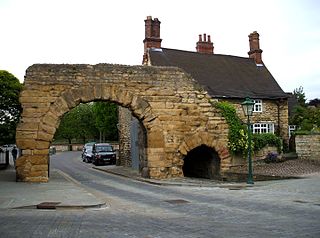
Glevum was a Roman fort in Roman Britain that became a "colonia" of retired legionaries in AD 97. Today, it is known as Gloucester, located in the English county of Gloucestershire. The name Glevum is taken by many present-day businesses in the area and also by the 26-mile Glevum Way, a long-distance footpath or recreational walk encircling modern Gloucester.

Eastgate and Eastgate Clock Grade I listed gate in the United Kingdom

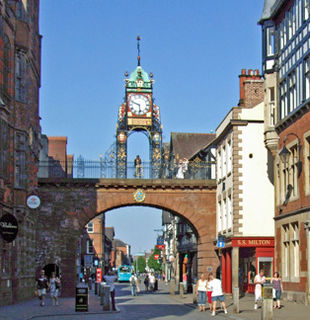
Eastgate and Eastgate Clock in Chester, Cheshire, England, stand on the site of the original entrance to the Roman fortress of Deva Victrix. It is a prominent landmark in the city of Chester and is said to be the most photographed clock in England after Big Ben.

Leicester City Centre human settlement in United Kingdom

Leicester City Centre is Leicester's historical commercial, cultural and transport hub and is home to its central business district. Its inner core is roughly delineated by the A594, Leicester's inner ring road, although the various central campuses of the University of Leicester, De Monfort University and Leicester College are adjacent to the inner ring road and could be considered to be a continuation of the City centre. In a similar way, the Leicester Royal Infirmary precinct, the New Walk business district (Southfields), the Welford Road Stadium of Leicester Tigers' RUFC and the King Power Stadium of Premier League Leicester City to the south, and the Golden Mile to the north could also be deemed to be extensions to the central core.

Edmonton City Centre building in Alberta, Canada

Edmonton City Centre is a shopping mall in downtown Edmonton, Alberta, Canada, across the street (west) from Churchill Square.

Newport city centre human settlement in United Kingdom

Newport city centre is traditionally regarded as the area of Newport, Wales bounded by the west bank of the River Usk, the George Street Bridge, the eastern flank of Stow Hill and the South Wales Main Line. Most of the city centre is contained within two conservation areas: the central area and the area around Lower Dock Street. Most of the city centre is located in the Stow Hill district.

Southampton City Centre human settlement in United Kingdom

Southampton City Centre is the commercial and organisational centre of the City of Southampton, and the transport hub of the city. Because Southampton is on the South Coast of England, the city centre is not at the geometric centre of the city, but at the southern extremity.

St Michaels Tower, Gloucester

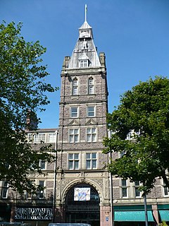
St Michael's Tower, Gloucester, stands at The Cross, where the four main streets of Gloucester meet. The Cross is also the highest point in the city. The Tower is on the corner of Eastgate and Southgate Streets and the entrance is in Southgate Street. It was built in 1465 on the site of the previous St Michael the Archangel. It is no longer used for religious ceremonies. It became a Grade II* listed building in 1952.

Streets in Gibraltar

Streets in the British Overseas Territory of Gibraltar are represented by road signs as in the United Kingdom. As of 2007, Gibraltar has a network of 29 kilometres (18 mi) of roads.

Basildon Town Centre

Basildon Town Centre in Basildon, Essex, is a planned town centre developed during the town's creation in the 1950s. The architect Sir Basil Spence worked on its design.

Eastgate Shopping Centre, Gloucester Gloucester, Gloucestershire, GL1

The Eastgate Shopping Centre is a two-story indoor shopping centre in Gloucester, England. It opened its portico entrance on 3 July 1973.

Hillfield Gardens, Gloucester

Hillfield Gardens is a public park on London Road, Gloucester, England. It houses several historical monuments.

9 and 9A Southgate Street, Gloucester

9 and 9A Southgate Street is a 17th-century Jacobean timber-framed merchant's house on Southgate Street, Gloucester. It has been a Grade I listed building since 23 January 1952. 9 Southgate Street is now occupied by Costa Coffee and 9A Southgate Street is occupied by The Tiger's Eye restaurant.

Brunswick Square, Gloucester

Brunswick Square is a 1.5-acre (0.61 ha) privately owned public garden with residential streets along three of its sides, in the English city of Gloucester. It is overlooked by the Christ Church to the east on Brunswick Road. The square is surrounded by terraced houses and flats with the Gloucester National Spiritualist Church on the north side and Gloucester House on the south side. There are nine grade listed buildings around the square. The square has been part of the Eastgate and St Michaels conservation area since 1968.

Gloucester Transport Hub

Gloucester Transport Hub is a bus station on Station Road in Gloucester, England.

References

  1. "Kings Walk Multi-Storey Car Park". Gloucester.gov. Retrieved 5 March 2017.
  2. Verey, David; Brooks, Alan (1970). "The City Centre:3". Gloucestershire:The Vale and the Forest of Dean. p. 487.
  3. 1 2 3 "Planning Concept Statement -KINGS QUARTER" (PDF). Gloucester Partnership. Retrieved 5 March 2017.
  4. 1 2 "Gloucester, 1835-1985: Topography". British History. Retrieved 5 March 2017.
  5. "Gloucester: Street names". British History. Retrieved 5 March 2017.
  6. Jordan, Christine (2015). "5. Notable Gloucestrians". Secret Gloucester.
  7. "Celebrating 40 years of the Eastgate Shopping Centre". The Citizen. 4 July 2013. Retrieved 19 February 2017.[ permanent dead link ]
  8. "Brexit halts £25million Gloucester Kings Walk investment deal". 15 August 2016. Retrieved 5 March 2017.
  9. "New owners announced for Kings Walk Shopping Centre". Gloucestershire Live. 10 July 2017. Retrieved 10 September 2017.
  10. "The £12m plan that could change shopping in Gloucester forever - and why Eastgate Street might never look the same again". Gloucestershire Live. 21 March 2018. Retrieved 24 March 2018.
  11. 1 2 "The King's Walk Bastion" (PDF). Gloucester History Festival. Retrieved 5 March 2017.
  12. "Gloucester Civic Trust - History" (PDF). Retrieved 5 March 2017.
  13. "Gloucester's hidden Roman history opened to the public". BBC News. 2 September 2016. Retrieved 5 March 2017.