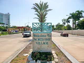
North Bay Village is a city located in Miami-Dade County, Florida. As of the 2000 census, the city had a total population of 6,733. As of 2010, the population recorded by the U.S. Census Bureau was 7,137.

Sag Harbor is an incorporated village in Suffolk County, New York, United States, in the towns of Southampton and East Hampton on eastern Long Island. The village developed as a working port on Gardiner's Bay. The population was 2,169 at the 2010 census.
Division No. 1, Subdivision A is an unorganized subdivision on the Avalon Peninsula in Newfoundland and Labrador, Canada. It is in Division No. 1, and lies between Trinity Bay and Placentia Bay.

Avalon is a federal electoral district on Newfoundland Island in Newfoundland and Labrador, Canada. It has been represented in the House of Commons of Canada since 2004.

Placentia Bay is a body of water on the southeast coast of Newfoundland, Canada. It is formed by Burin Peninsula on the west and Avalon Peninsula on the east. Fishing grounds in the bay were used by native people long before the first European fishermen arrived in the 16th century. For a time, the French controlled the bay. They built their capital at Placentia on the east coast. The British gained Placentia during the Treaty of Utrecht in 1713. The town and nearby Castle Hill are national historic sites. English settlement followed in the bay and today the main communities are Burin, Marystown, and Placentia.
Broad Cove is on King's Island, Placentia Bay, Newfoundland, Canada. It was one of five communities on King's Island; the others were: Tack's Beach, Best Harbour, Baker's Cove, Cooper's Cove and Yaulis Cove. All the communities had the same postal address, which was "Tacks Beach, Placentia Bay, Newfoundland".
Merasheen is a community located on the southwestern tip of Merasheen Island in Placentia Bay in Newfoundland and Labrador, Canada. It was one of the largest and most prosperous communities in Placentia Bay to be resettled, with the provincial government paying residents to abandon the community and relocate to designated growth centres during the 1960s.
Tack's Beach was a small community located on King Island in Placentia Bay. The population was 252 in 1921. The population had declined to 140 by 1966 due to a decline in fish stocks and the community was depopulated in 1967.
Red Island is a former village about 12 miles northwest of Placentia, Newfoundland and Labrador in Placentia Bay. It had five families in 1864, and had a population of approximately 350 in the 1945 census.1 The village of 283 was depopulated in October 1968, during the provincial government's Resettlement Program. In modern times, many people have cabins there and use it as a summer retreat.
Western Cove is located on Bar Haven Island in Placentia Bay. It is formed between Newfoundland, Labrador, and Bar Haven.
Darby's Harbour is a locality and former settlement located southwest of Swift Current on Merasheen Island, Placentia Bay, Newfoundland, Canada. It had a post office in 1940. The 1935 population was 21, but by 1990 it was uninhabited.
Dunville is a neighborhood located in the Town of Placentia, it was earlier called Northeast or North East Placentia. The name was formed from "Dunphy's Village" a part of Northeast Placentia. It is a community that makes up the north-eastern section of the Town of Placentia. It stretches approximately 8km along the northern shore of the North-East Arm of Placentia Bay.
Oderin Island is an island in the province of Newfoundland and Labrador in western Placentia Bay, located about 30 km northeast of Marystown. Oderin was originally settled by the French who considered it an important fishing post and had fortified it against the English. The name was originally Audierne, named after a town in France. In 1712, the French authorities in Placentia ordered all the buildings and fishing premises to be burned or destroyed, in part to deny to English the use of the site but also as retribution against the local French merchant Lafosse who had deserted to and collaborated with the English. This did not happen, however, as English Captain Tavener's second report indicates that Lafosse's abandoned wife was still present in May 1718 and running a prosperous operation.
Harbour Buffett was a Way Office established in 1854. The first Waymaster was Thomas E. Collett. It was changed to a Post Office on May 30th 1891. It was only served by the Canadian National Railway in 1953.
Great Brule is a settlement on the northern tip of Merasheen Island in Placentia Bay in Newfoundland and Labrador. The first permanent residents in the community were recorded in 1813. The cod fishery was the primary source of employment in Great Brule. Between 1951 and 1956 the community was abandoned and most of the residents relocated to larger centers in Placentia Bay.
Blue Hill Bay is a bay lying to the west of Mount Desert Island in Hancock County, Maine, United States. Approximately 14 mi (23 km) long, its southern boundaries are set by Swan's Island and Placentia Island at its entrance; the town of Blue Hill lies at the far end. Morgan Bay, Union River Bay, and Western Bay empty into it. Long Island in the north of the bay is the largest uninhabited island in Maine.
Division No. 1, Subdivision B is an unorganized subdivision on the Avalon Peninsula in Newfoundland and Labrador, Canada. It is in Division 1 and contains the unorganized communities of Iona, Little Barasway, Placentia Junction, Point Verde and Ship Harbour.
Division No. 1, Subdivision C is an unorganized subdivision on the Avalon Peninsula in Newfoundland and Labrador, Canada. It is in Division 1 and contains the unincorporated communities of Cape St. Mary's, Cuslett, Gooseberry Cove, Great Barasway, Lears Cove, Patrick's Cove-Angels Cove, Ship Cove and Stoney House.

Division No. 1, Subdivision G is an unorganized subdivision on the Avalon Peninsula in Newfoundland and Labrador, Canada. It is in Division 1 and contains the unincorporated communities of Baccalieu Island, Besom Cove, Bradley's Cove, Burnt Point, Caplin Cove, Daniel's Cove, Grates Cove, Gull Island, Job's Cove, Kingston, Long Beach, Lower Island Cove, Low Point, Northern Bay, Ochre Pit Cove, Red Head Cove, Riverhead, Smooth Cove and Western Bay.
Long Island is a long narrow island located in the inner portion of Placentia Bay. The longest axis of the island lies in a north-south direction. It is approximately 24 kilometres long and just over 3 kilometres at its widest point. Long Island along with Merasheen Island and Red Island make up the majority of the islands in Placentia Bay. Long Island is located approximately 22 kilometres northwest of Argentia. It is separated from Merasheen Island to the west by a 24 kilometre long channel that narrows to within 2.12 kilometres. Red Island is approximately 10 kilometres to the southwest of Long Island.