External links
Coordinates: 7°0′N79°56′E / 7.000°N 79.933°E
| | This Western Province, Sri Lanka location article is a stub. You can help Wikipedia by expanding it. |
Kirimetiyagara (also written as Kirimatiyagara) is a small village situated in the western part of Sri Lanka. The distance to Colombo, the commercial capital of Sri Lanka, is about 10 miles from Kirimetiyagara. The closest city to Kirimetiyagara is Kadawatha, which is on the Kandy Road. St Anthony's Catholic church is the main attraction in Kirimetiyagara.
Coordinates: 7°0′N79°56′E / 7.000°N 79.933°E
| | This Western Province, Sri Lanka location article is a stub. You can help Wikipedia by expanding it. |
Malwana is a town of 36,050 inhabitants in the Western Province of Sri Lanka. It is situated on the banks of the Kelani River, 14 km north-east of Colombo. It is part of the Gampaha District and Biyagama electoral division. Recognized all over Sri Lanka for the exotic Rambutan fruit that grows in the area, Malwana forms part of the Biyagama free-trade zone, where government incentives has drawn investors from around the world into manufacturing ventures involving clothing and light industry. Malwana Muslim area exist with several sub-areas as well as Raxapana, Vidanagoda, Malwana- Town, Daluggala, Thottam, Pallam, Kandawatta, Burulapitiya, Rajamalwatta, Malwatta, Walgama, Ulahitiwala, Pelangahawatta, Paaluwatta, Yatihena and other areas Yabaraluwa, Mapitigama, Barukanda, Wekanda, Nagahawatta.

Wadduwa is a town in the Western Province of Sri Lanka. It is situated on the western coast of Sri Lanka, about 33 km (21 mi) south of Colombo. It spans from 30.5 to 36.5 km area along the Galle Road, 4.5 km to the land side and 1 km to the seaside. It is also famous for its rich cultivation of coconut palms and as a major producer of toddy and vinegar. There are few historical places in the area such as ancient Catholic church and Dhaaldawatta Purana Maha Viharaya. Wadduwa is popular for the products made from coconut fibre such as brooms, carpets etc.

Ceylon was the British Crown colony of present-day Sri Lanka between 1796 and 4 February 1948. Initially, the area it covered did not include the Kingdom of Kandy, which was a protectorate, but from 1817 to 1948 the British possessions included the whole island of Ceylon, now the nation of Sri Lanka.

Vankalai or Vangalai or Vangkaalai is a predominantly fishing and farming village situated in Mannar District of the Northern Province of Sri Lanka. It lies along the Naanaattan Road with the sea on its west connects to Indian Ocean. The shores from Vankalai 20 km south to the ancient Tamil subsidiary port of Kudiramalai formed the world's most famous pearl fishing banks in the classical and medieval periods. Its northern boundary is the historic Hindu shrine of Thiru Ketheeswaram.
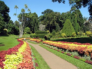
Royal Botanic Gardens, Peradeniya are about 5.5 km to the west of the city of Kandy in the Central Province of Sri Lanka. In 2016, the garden was visited by 1.2 million locals and 400,000 foreign visitors. It is near the Mahaweli River. It is renowned for its collection of orchids. The garden includes more than 4000 species of plants, including orchids, spices, medicinal plants and palm trees. Attached to it is the "National Herbarium of Sri Lanka". The total area of the botanical garden is 147 acres (0.59 km2), at 460 meters above sea level, and with a 200-day annual rainfall. It is managed by the Division of National Botanic Gardens of the Department of Agriculture.
Kayts Electoral District was an electoral district of Sri Lanka between August 1947 and February 1989. The district was named after the island of Kayts in Jaffna District, Northern Province. The 1978 Constitution of Sri Lanka introduced the proportional representation electoral system for electing members of Parliament. The existing 160 mainly single-member electoral districts were replaced with 22 multi-member electoral districts. Kayts electoral district was replaced by the Jaffna multi-member electoral district at the 1989 general elections, the first under the PR system, though Kayts continues to be a polling division of the multi-member electoral district.
Chilaw is a large town in Puttalam District, North Western Province, Sri Lanka. It is governed by an urban council. The town is located, 80 km away from the capital Colombo via Negombo.
Achchankulam is a small town in Sri Lanka. It is located within Northern Province.
Adampam is a small town in Sri Lanka. It is located within Northern Province.
Tanakkankulam is a small town in Sri Lanka. It is located within Northern Province.
Thiruvadinilayam is a small town in Sri Lanka. It is located within Northern Province.
Agalakumbura is a village in the Nuwara Eliya District, Central Province, Sri Lanka.
Gurulupota is a village in Sri Lanka. It is located within Central Province.
Yatimadura is a village in Sri Lanka. It is located within Central Province.
Hewanewala is a village in Sri Lanka. It is located within Central Province.
Rankiriyagolla is a village in Sri Lanka. It is located within Central Province.
Welgahawadiya is a village in Sri Lanka. It is located within Central Province.
Wilgomuwa is a village in Sri Lanka. It is located within the Central Province.
Dalupitiya is a small village situated in the western part of Sri Lanka. The distance to Colombo, the commercial capital of Sri Lanka, is about 10 miles from Kirimetiyagara. The closest city to Dalupitiya is Kadawatha, which is on the Kandy Road.
Chulipuram is a village in Jaffna District, Sri Lanka. Its area is 7.5 km2. It is located about 16 kilometers north-west of Jaffna town along the Karainagar-Manipay-Jaffna road AB17.