
The Bass Islands consist primarily of Rapa Iti and Marotiri. They are usually considered to be the southernmost of the Austral Islands, although this classification is more one of geographic and political expediency than because of similarities between them and the rest of the Austral Islands. The Bass Islands, lying several degrees outside the tropics, are the southernmost islands in French Polynesia. Culturally, the Bass Islands appear to have been colonized about the same time as Tahiti and the Marquesas, and the culture and language (Rapan) appear to have diverged about the same time as well, indicating that they developed in relative isolation almost from the time of first settlement.
Ḵwiḵwa̱sut'inux̱w Ha̱xwa'mis, formerly the Kwicksutaineuk-ah-kwa-mish First Nation is a First Nations band government based on northern Vancouver Island in British Columbia, Canada, in the Queen Charlotte Strait region. It is a member of the Musgamagw Tsawataineuk Tribal Council, along with the ‘Namgis First Nation and the Tsawataineuk First Nation. The Kwikwasut'inuxw and Haxwa'mis are two of the many subgroups of the peoples known as Kwakwaka'wakw, which has two meanings: "smoke of the world" or "beach at the north side of the river."
The Esk'etemc First Nation, also known as the Alkali Lake Indian Band, is a First Nations government of the Secwepemc (Shuswap) people, located at Alkali Lake in the Cariboo region of the Central Interior of the Canadian province of British Columbia. It was created when the government of the then-Colony of British Columbia established an Indian reserve system in the 1860s. It is one of three Secwepemc bands that is not a member of either the Shuswap Nation Tribal Council or the Northern Shuswap Tribal Council.
The Tlʼetinqox-tʼin Government Office is a First Nations government located in the Chilcotin District in the western Central Interior region of the Canadian province of British Columbia. Governing a reserve communities near Alexis Creek known as Anaham Reserve First Nations or Anaham, it is a member of the Tsilhqotʼin Tribal Council aka known as the Tsilhqotʼin National Government. The main reserve is officially known as Anahim's Flat No. 1, and is more commonly as Anaham. Other reserves are Anahim's Meadow No. 2 and 2A, and Anahim Indian Reserves Nos. 3 through 18. Anaham, or Anahim and Alexis were chiefs of the Tsilhqotʼin during the Chilcotin War of 1864, although they and their people did not take part in the hostilities.

Diabo is a department or commune of Gourma Province in north-eastern Burkina Faso. Its capital lies at the town of Diabo.
The Tahltan First Nation, also known as the Tahltan Indian Band, is a band government of the Tahltan people. Their main community and reserves are located at Telegraph Creek, British Columbia. Their language is the Tahltan language, which is an Athabaskan language also known as Nahanni, is closely related to Kaska and Dunneza. Their Indian and Northern Affairs Canada band number is 682. The Tahltan First Nation is joined with the Iskut First Nation in a combined tribal council-type organization known as the Tahltan Nation.
Thompson Sound is a sound on the Central Coast of British Columbia, Canada, located on the east side of Tribune Channel and to the east of Gilford Island, part of the Broughton Archipelago. The headland on the north side of the sound's entrance is London Point at 50°46′09″N126°07′07″W. The south side of the entrance is demarcated by Cleave Point at 50°44′35″N126°07′28″W.
Wakeman Sound is a sound on the South Coast of British Columbia, Canada, located in the area north of the Broughton Archipelago, which lies on the north side of Queen Charlotte Strait, on the northeast side of Broughton Island. It is a sidewater opening of and opening north off Kingcome Inlet.
Sukma is a town in Sukma district in Chhattisgarh, India.
Sosanpal is a town in Bastar district, Chhattisgarh, India.
Konta is a Municipal Council and tehsil headquarters in Sukma district, Chhattisgarh, India. Konta is a model town situated near bank of sabri River and Konta Legislative Assembly constituency is one of the 90 Legislative Assembly
Bamanbore is a town in Surendranagar district of Gujarat, India.
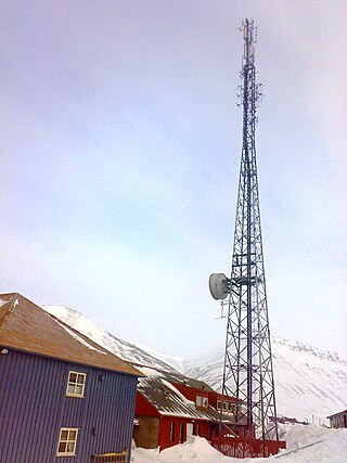
Svalbard Radio is a coast radio station established in 1911 at Finneset in Svalbard, Norway. In 1930, it moved to Skjæringa in Longyearbyen and since 1975 it has been co-located with Svalbard Airport, Longyear. It has been remote-controlled from Bodø Radio since 2006.
Tadmetla, also known as Tadmetala is a village in Chhattisgarh state, India. It is located in the Konta tehsil of Sukma in the Bastar division.
Lindell Beach is a rural farming village in the Columbia Valley of the Lower Mainland region of the province of British Columbia, Canada, lying south of the City of Chilliwack. It is located at the south end of Cultus Lake which is the main waterbody in the Columbia Valley in the South Fraser Valley, and just north of the boundary of the United States.
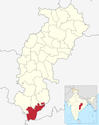
Sukma district is the southernmost district in the Indian state of Chhattisgarh. It is located in the Bastar region, known for its tribal culture. Sukma district borders with Odisha, Telangana and Andhra Pradesh.
On 13 March 2018, at least nine Central Reserve Police Force (CRPF) personnel were killed and six others were injured when Maoists blew up a mine-protected vehicle with an IED in Sukma district, Chhattisgarh, India.
Konta is one of the 90 Legislative Assembly constituencies of Chhattisgarh state in India.

