
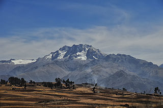
Calca Province is one of thirteen provinces in the Cusco Region in the southern highlands of Peru. Its seat is Calca.
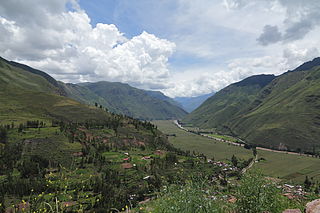
Calca District is one of eight districts of the province Calca in Peru.

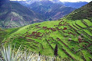
Coya District is one of eight districts of the Calca Province in the Cusco Region of Peru.

Taray District is one of eight districts of the Calca Province in the Cusco Region in Peru. Its seat is Taray. The town lies near Pisac, southwest of it, at a stream called Pawayuq (Pahuayoc), an affluent of Willkanuta River.
Queuñacocha or Hatun Queuñacocha is a small lake in the Urubamba mountain range of the Cusco Region, Lares District, Calca Province, Peru. The lake lies north of Chicón, Sirihuani and Parorjo and southwest of Quisuarani, at an altitude of about 4,170 m. It is 200 metres (660 ft) long, and 140 metres (460 ft) wide at its widest point. West of it there is another small lake called Quellacocha.

Ccerayoc is a 5,092-metre-high (16,706 ft) mountain in the Urubamba mountain range in the Andes of Peru. It is located in the Cusco Region, Calca Province, in the districts Calca and Lares. It lies immediately east of Sahuasiray and northeast of Condorhuachana.

Kunka is a mountain in the La Raya mountain range in the Andes of Peru. It is situated at the La Raya Pass and the road and rail which connect Cusco with Lake Titicaca. It is located in the Cusco Region, Canas Province, Layo District, and in the Puno Region, Melgar Province, Santa Rosa District, and about 5,200 metres (17,060 ft) high. Kunka lies southwest of the mountains Yana Khuchilla and Chimpulla. Other neighboring mountains are Huch'uy K'uchu north of it and Hatun Ichhuna Kunka in the south. Between the road and the mountain there is a little lake named Q'umirqucha.
Pucaorjo is a 4,776-metre-high (15,669 ft) mountain in the Urubamba mountain range in the Andes of Peru. It is situated in the Cusco Region, Calca Province, Lares District. Pucaorjo is situated northeast of Sirihuani, northwest of Sahuasiray and east of Parorjo, at the Lares trek. One of the nearest populated places is Quishuarani.
Parorjo is a mountain in the Urubamba mountain range in the Andes of Peru. It is situated in the Cusco Region, Calca Province, Lares District. Its summit is 4,891 m (16,047 ft) high. Parorjo is situated at the Lares trek north of Chicón and Sirihuani and west of Pucaorjo. One of the nearest populated places is Quishuarani. There is a small lake at its feet named Parococha.
Kiswarani Q'asa is a mountain in the Andes of Peru. Its summit reaches about 4,862.8 m (15,954 ft) above sea level. The mountain is located in the Cusco Region, Espinar Province, Coporaque District.

Huamanchoque is a 5,156-metre-high (16,916 ft) mountain in the Urubamba mountain range in the Andes of Peru. It is located in the Cusco Region, Calca Province, Calca District, north of the Vilcanota River. Huamanchoque lies at the Cancha Cancha valley where the Lares trek route passes by. It is situated south of Canchacanchajasa, southwest of Sahuasiray and Cóndorhuachana, and north of a lower peak named Cóndorhuachana. One of the nearest towns is Huayllabamba.

Canchacanchajasa is a 4,987-metre-high (16,362 ft) mountain in the Urubamba mountain range in the Andes of Peru. It is located in the Cusco Region, Calca Province, Calca District, north of the Urubamba River. Canchacanchajasa is situated southeast of Sirihuani, north of Cóndorhuachana and Huamanchoque and southwest of Sahuasiray. It lies in the upper part of the Cancha Cancha valley (kancha kancha) at the Lares trek.
Pachakutiq is a mountain in the Andes of Peru, about 4,400 metres (14,436 ft) high. It is located in the Cusco Region, Calca Province, on the border of the districts Calca and Lares. Pachakutiq is situated east of the Urupampa mountain range. It lies north-east of the mountain Q'irayuq and south-west of the mountains Yanaqaqa and Chhullunkunayuq.
Kiswarani is a mountain in the Andes of Peru, about 4,800 metres (15,748 ft) high. It is located in the Apurímac Region, Antabamba Province, Sabaino District, and in the Aymaraes Province, Caraybamba District. Kiswarani lies southeast of Pisti.
Jatun Huiscana is a mountain in the Urubamba mountain range in the Andes of Peru, about 4,600 metres (15,092 ft) high. It lies in the Cusco Region, Calca Province, Lares District. Jatun Huiscana is situated northwest of Ccerayoc and Yanaorcco, and northeast of Sahuasiray.
Chaquicocha is a 4,895-metre-high (16,060 ft) mountain at a little lake of that name in the Urubamba mountain range in the Andes of Peru. It is located in the Cusco Region, Calca Province, Calca District, and in the Urubamba Province, in the districts of Huayllabamba and Yucay. It lies southwest of Huamanchoque and southeast of Chicon.
Hatun Pukara is a mountain in the Andes of Peru, about 4,000 metres (13,123 ft) high. It is located in the Cusco Region, Calca Province, on the border of the districts of Coya and Taray, southwest of Taray. It lies south of the Willkanuta River.
Qhiwar is a mountain in the Cusco Region in Peru, about 4,400 metres (14,436 ft) high. It is situated in the Calca Province, San Salvador District. Qhiwar lies between Hatun Punta in the east and Wallwa Qhata in the southwest.
P'unquchayuq is a mountain in the Cusco Region in Peru, about 4,400 metres (14,436 ft) high. It is situated in the Calca Province, San Salvador District, and in the Paucartambo Province, Caicay District. P'unquchayuq lies south of Hatun Punta and southeast of Qhiwar.


