
Maswa District is one of the five districts of the Simiyu Region of Tanzania Inhabited by Sukuma. It is bordered to the north by Magu District and Itilima District, to the east by the Meatu District, to the south by the Kishapu District, and to the west by the Kwimba District. Its administrative centre is the town of Maswa.

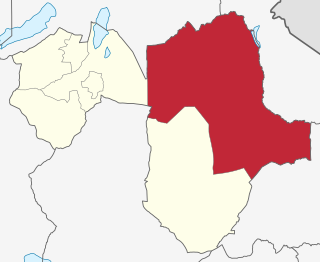
Meatu District is one of the five districts of the Simiyu Region of Tanzania. It is bordered to the north by the Itilima District, to the west by the Maswa District and Shinyanga Region to the east by the Arusha Region, to the southeast by the Manyara Region and to the south by the Singida Region. Its district capital is the town of Mwanhuzi.

Urambo is one of the seven districts of the Tabora Region of Tanzania. It is bordered to the north by the Kaliua District, to the east by the Uyui District, to the southeast by the Sikonge District, and to the southwest by the Katavi Region. Its administrative seat is the town of Urambo.
Nzega District is one of the seven districts of the Tabora Region of Tanzania. It is bordered to the north by Shinyanga Region, to the south and southwest by Uyui District and to the east by Igunga District. Its administrative seat is the town of Nzega.

Uyui District is one of the seven districts of the Tabora Region of Tanzania. It is bordered to the north by Nzega District and Igunga District as well as by the Shinyanga Region, to the south by Sikonge District, to the west by Urambo District and Kaliua District, and to the east by the Singida Region. Tabora Urban District is an enclave within the Uyui District. Its administrative seat is the city of Tabora.
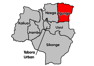
Igunga is one of the seven districts of the Tabora Region of Tanzania. It is bordered to the north by the Shinyanga Region, to the east by the Singida Region, to the south by the Uyui District and to the west by the Nzega District. Its administrative seat is the town of Igunga. Igunga is now divided by two Constituencys: Igunga Constituency and Manonga Constituency, whereby Manonga town is Choma Chankola. Igunga is the second district in production

Sikonge District is one of the seven districts of the Tabora Region of Tanzania. The town of Sikonge is the administrative seat. The district has an area of 27,873 square kilometres (10,762 sq mi), but 26,834 square kilometres (10,361 sq mi) of it is in forest and game reserves. It is bordered to the northwest by Urambo District, to the north by Uyui District, to the east by Manyoni District of Singida Region, to the south by Chunya District of Mbeya Region, and to the southwest by Mlele District of Katavi Region.

Biharamulo District is one of the eight districts of the Kagera Region of Tanzania. It is bordered to the north by Karagwe District and Muleba District, to the east and south by Geita Region, to the west by Ngara District, and to the southwest by the Kigoma Region. Its administrative seat is Biharamulo town. Biharamulo Game Reserve is located within the borders of the district.

Tarime District is one of the seven districts of the Mara Region of Tanzania, East Africa. It was previously known as the "North Mara District". Its district capital is Tarime town. It is bordered from the north to east by the Kenyan districts of Migori, Trans Mara and Kuria East and West Districts, and to the east by the Maasai Mara game reserve. To the south it is bordered across the Mara River by the Serengeti and Butiama districts, and to the west by Rorya District.

Same is one of the seven districts of the Kilimanjaro Region of Tanzania. It is bordered to the north by the Mwanga District, to the northeast by Kenya, to the south and southeast by the Korogwe District and Lushoto District of Tanga Region, and to the west by Simanjiro District of Manyara Region. The district capital is the town of Same, Tanzania. The south Pare Mountains are located within the district's boundaries and so is a part of Mkomazi National Park. According to the 2002 Tanzania National Census, the population of the Same District was 212,235. The population had risen to 300,303 according to the 2022 Tanzania National Census.
Mwanga is one of the seven districts of the Kilimanjaro Region of Tanzania. The district covers an area of 1,831 km2 (707 sq mi), It is bordered to the northeast by Kenya, to the northwest by the Moshi Rural District, to the southwest by Simanjiro District of Manyara Region, and to the south by the Same District. Its administrative seat is the town of Mwanga. The tallest peak in the district is Kindoroko at 2,100m in the North Pare Mountains that are located entirely within the district. According to the 2022 Tanzania National Census, the population of Mwanga District was 148,763.

Moshi Urban District is an administrative district located in Kilimanjaro Region of Tanzania. The district is home to regional capital of Kilimanjaro Region, namely Moshi. The district covers an area of 63.39 km2 (24.48 sq mi). The district is surrounded on the west by Moshi Rural District, to the east by the Hai District. According to the 2022 Tanzania National Census, the population of Moshi Urban District was 221,733.
Kilindi is one of eleven administrative districts of Tanga Region in Tanzania. The District covers an area of 6,444 km2 (2,488 sq mi). It is bordered to the east by the Handeni District and Handeni Town Council, to the south west by the Kiteto District and north west by the Simanjiro District of Manyara Region. Kilindi District is bordered to the south by Gairo District and Kilosa District of Morogoro Region. The district created from Handeni District in 2002. The district seat (capital) is the town of Songe. According to the 2022 census, the district has a total population of 398,391.

Kilosa District is one of the six districts of the Morogoro Region of Tanzania. Its administrative seat is the town of Kilosa. Kilosa District covers 14,918 square kilometres (5,760 sq mi). It is bordered to the north by the Manyara Region, to the northeast by the Tanga Region, to the east by Mvomero District, to the southeast by Morogoro Rural District, to the south by Kilombero District, to the southwest by the Iringa Region and to the west by the Dodoma Region. Kilosa District is home to Mikumi National Park.
Simanjiro District is one of the six districts of the Manyara Region of Tanzania. It is bordered to the north by Arusha Region, to the north east by Kilimanjaro Region, to the south east by Tanga Region, to the south by Kiteto District, to the south west by Dodoma Region and to the west by Babati Rural District. The district headquarters are located in Orkesumet. According to the 2022 Tanzania National Census, the population of Simanjro District was 291,169. Simanjiro District is endowed with gemstones, being the only location on the planet that has tanzanite. Simanjiro was also where the first tsavolite was discovered.

Hanang District is one of the six districts of the Manyara Region of Tanzania. It is bordered to the north by the Mbulu District and Babati Rural District, to the southeast by the Dodoma Region and to the southwest by the Singida Region. Mount Hanang is located within the boundaries of the district.

Iramba is one of the six districts of the Singida Region of central Tanzania. It is bordered to the Northwest by the Shinyanga Region, to the North by Simiyu Region, to the east by the Mkalama District, to the South by Ikungi District and to the West by the Tabora Region. Its administrative seat is the town of Kiomboi.
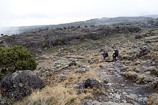
Siha is one of the seven administrative districts of Kilimanjaro Region in Tanzania. The district covers approximately 1,217 square kilometres (470 sq mi). It is bordered to the west by Meru District in Arusha Region and to the northeast by Rombo District and the southeast Hai District. The western part of Mount Kilimanjaro is located within the district's boundaries.
Kibaya is a town and a ward in the Manyara Region of Tanzania. It is the district headquarter of Kiteto District.
Lindi Municipal District is one of the eight administrative districts of Lindi Region in Tanzania. The district covers an area of 1,064 km2 (411 sq mi).The district is comparable in size to the land area of the nation state of Sao Tome and Principe. It is entirely bordered on land by Lindi District and its faces the Indian Ocean to the east. Lindi Municipal District hosts the region's capital is located in the ward of Ndoro in the town of Lindi. According to the 2012 census, the district has a total population of 78,841.
