
The Brothers is a group of small islands in Cook Strait, New Zealand, off the east coast of Arapaoa Island.

Haʻapai is a group of islands, islets, reefs, and shoals in the central part of Tonga. It has a combined land area of 109.30 square kilometres (42.20 sq mi). The Tongatapu island group lies to its south, and the Vavaʻu group lies to its north. Seventeen of the Haʻapai islands are inhabited. Their combined population is 5,419. The highest point in the Ha‘apai group, and in all of Tonga, is on Kao, which rises almost 1,050 metres (3,440 ft) above sea level.

ʻEua[ʔe.ˈu.a] is an island in the kingdom of Tonga. It is close to Tongatapu, but forms a separate administrative division. It has an area of 87.44 km2 (33.76 sq mi), and a population in 2021 of 4,903 people.

Matuku is a tiny island in Lulunga, a part of Haʻapai in Tonga. It is easily reached by outboard motorboat from the neighbouring hub of Haʻafeva and is on the course from there to the culturally important island of Kotu.

Metis Shoal, also known as Lateiki Island, is a volcanic island at the top of a submarine volcano in Tonga, located between the islands of Kao and Late. The current island formed in October 2019, when a smaller island disappeared after 24 years.
Foa is an island in Tonga. It is located within the Haʻapai group in the centre of the country, to northeast of the national capital of Nukuʻalofa.
Hakauata is an island in Tonga. It is located within the Ha'apai Group in the center of the country, to northeast of the national capital of Nukuʻalofa.

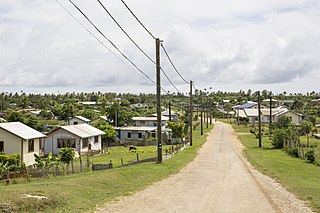
Lifuka is an island in the Kingdom of Tonga. It is located within the Haʻapai Group in the centre of the country, to northeast of the national capital of Nukuʻalofa.
Lofanga is an island in Tonga. It is located within the Ha'apai Group in the centre of the country, to northeast of the national capital of Nukuʻalofa. The island had a population of 137 at 2016, and an area of 1.45 km2.

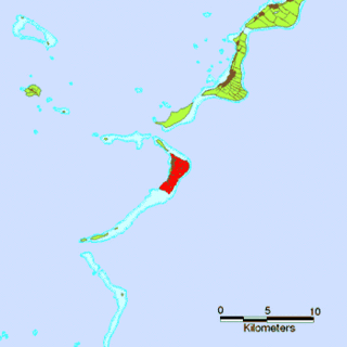
Haʻano is an island in the Haʻapai islands of Tonga. To the south are the islands of Foa and Lifuka.
ʻUiha is an island in Lifuka district, in the Haʻapai islands of Tonga. It had a population of 638 in 2006 and an area of 5.36 km2 (2.07 sq mi). The island has two villages, ʻUiha and Felemea.

Kilifarevo Island is an ice-free island in the Aitcho group on the west side of English Strait in the South Shetland Islands, Antarctica. The island is situated 850 m (930 yd) northwest of Jorge Island, 460 m (500 yd) north of Riksa Islands and 350 m (380 yd) southeast of Morris Rock. Extending 640 by 350 m, surface area 11 hectares. The area was visited by early 19th century sealers.
Tokulu is an island in Lulunga district, in the Ha'apai islands of Tonga.

Tungua is an island in Lulunga district, in the Ha'apai islands of Tonga. The island had a population of 187 in 2016.
Fangale'ounga is a settlement in Foa island, Tonga. It had a population of 140 in 2016.
Muitoa is a settlement in Ha'ano island, Tonga. It had a population of 53 in 2016.

Tongoleleka is a settlement in Lifuka island, Tonga.
Haʻatoʻu is a settlement in Lifuka island, Tonga.
Tatafa is an islet which belongs to ʻUiha island, Tonga. It is located within the Ha'apai Group.
