The Oslo Tunnel is a 3,632-metre (11,916 ft), double-track, railway tunnel which runs between Olav Kyrres plass and Oslo Central Station (Oslo S) in Oslo, Norway. The tunnel constitutes the eastern-most section of the Drammen Line and runs below the central business district of Oslo. It features the four-track Nationaltheatret Station, Norway's second-busiest railway station, where the Oslo Tunnels lies directly beneath the Common Tunnel of the Oslo Metro. At Frogner, the Elisenberg Station was built, but has never been used. The tunnel is the busiest section of railway line in Norway and serves all west-bound trains from Oslo, including many services of the Oslo Commuter Rail and the Airport Express Train.

Lieråsen Tunnel is a single-tubed railway tunnel of the Drammen Line situated in Asker, Røyken and Lier in Norway. At a length of 10.723 kilometers (6.663 mi), the double track tunnel is located immediately between Asker Station and Lier Station. It is used for a mix of short- and long-haul passenger trains and freight trains.
Elisenberg Station is an unfinished railway station within the Oslo Tunnel on the Drammen Line in Oslo, Norway. The ghost station was partially built during the construction of the tunnel between 1971 and 1980, but has never been put into use. It is located between Nationaltheatret Station and Skøyen Station, at Elisenberg in Frogner. A 220-meter (720 ft) long center platform and part of the access way has been built, but never completed. While the station initially was not put into use because of lack of funds to complete it, it is now unlikely that it will ever be completed, as the need for a station has disappeared and an opening would need a large investment of funds.

The Løren Line is a 1.6-kilometer (1.0 mi) line of the Oslo Metro. Located entirely underground, it runs through the neighborhoods of Sinsen, Løren and Økern in Bjerke, creating a connection between the Ring Line with the Grorud Line. The line features one station, Løren. It is served by metro trains which run down the Grorud Line and then connect to the Ring Line. It allows for higher capacity on the metro as more passengers a transported via the Ring Line instead of through the congested Common Tunnel. Construction started in June 2013 and the line opened on 3 April 2016.
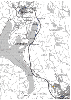
The Ringerike Line is a proposed 40-kilometre (25 mi) extension of the Bergen Line from Hønefoss to Sandvika, Norway. It would reduce travel from Oslo to Bergen by 60 kilometres (37 mi) and 50 minutes. Currently trains from the Bergen Line to Oslo must run via Drammen on the Randsfjord Line and the Drammen Line, or via Roa on the Roa–Hønefoss Line and the Gjøvik Line.

Nordberg was a station on the Sognsvann Line of the Oslo Metro in Oslo, Norway. It was opened on 10 October 1934, and was located between Østhorn and Holstein stations, in a level crossing with the steep road Borgestadveien. The station saw several accidents, and was closed on 5 May 1992 when the Sognsvann Line was upgraded to rapid transit standard. An underpass was constructed to allow pedestrians pass under the tracks.

The Granfoss Tunnel is a set of two tunnels on Ring 3 in Oslo, Norway. The two tunnels are 2.1 kilometers (1.3 mi) long and they are part of the Granfoss Line, a 2.9-kilometer (1.8 mi) stretch of motorway which was opened in 1992 connecting Ring 3 with the European route E18. The name comes from the Granfossen waterfall on the Lysakerelva river, which passes nearby. The two tunnels run from Lysaker to Mustad, and from Mustad to Ullern Church, respectively.

Kadettangen is a small peninsula outside of Sandvika in Bærum, Norway. Originally named Sandvikstangen, it got its current name from the cadet training conducted by the Norwegian Military Academy for the better part of the nineteenth century. The peninsula is now used mainly for boating, beach life and sports, being the home ground of association football club Bærum SK.
Vinterbro is a village in the municipality of Ås, Akershus, Norway. It has 3,000 residents in the subdivisions Togrenda and Sjøskogen. The area features two primary schools and four kindergartens.
The Bekkestua Tunnel is a road tunnel that runs under Bekkestua in Bærum, Norway. It forms a part of the Norwegian National Road 160, starts northeast of Bekkestua to ease this population and commercial centre of heavy traffic, and emerges in the southwest near Gjønnes Station. It was opened in 1994, and was financed by the Oslo Package 1.

Rikshospitalet is a light rail tram station at the end of the Ullevål Hageby Line of the Oslo Tramway. It is located at Rikshospitalet, the Norwegian National Hospital, at Gaustad in Oslo, Norway.

Rådhusplassen is a square located between Oslo City Hall and the Oslofjord in Vika, Oslo, Norway. Previously used as a road and part of European route E18, it has since 1994 served as a recreational area. North of the square stands the city hall, to the south the fjord, to the east Akershus Fortress and to the east the former Western Railway Station.

Oslo Package 1 was a political agreement and plan for introducing an urban toll ring around Oslo, Norway, and making 31 investments to road infrastructure in Oslo and Akershus. The package was approved in 1988, and toll charges were introduced in 1990. It was supplemented by Oslo Package 2, which included a similar scheme for public transport. In 2008, they were both replaced by Oslo Package 3.

Bispelokket was a Norwegian three-level stack interchange roundabout in Bjørvika, Oslo. European Route E18 and Norwegian National Road 162 jointed at this point, which also served as the official traffical centre of the city. The new roundabout at Postgirobygget is from October 31, 2011, the new traffical centre of Oslo.

The Fjord City is an urban renewal project for the waterfront part of the center of Oslo, Norway. The first redevelopment was at Aker Brygge during the 1980s. Bjørvika and Tjuvholmen followed up during the 2000s, while the remaining parts of the Port of Oslo will be developed in the 2010s. The port will be relocated to Sørhavna. The planning is performed by the Oslo Waterfront Planning Office. Major investments in the area include a new Central Railway Station, an already completed Oslo Opera House, and the commercial buildings in the Barcode Project. Several large cultural institutions will be moved to Bjørvika, including moving the Oseberg Ship, Oslo Public Library, and the Munch Museum. The main barrier between the city and the fjord will disappear when European Route E18 is relocated to the Bjørvika Tunnel.

Crime in Norway is countered by Norway's law enforcement agencies.
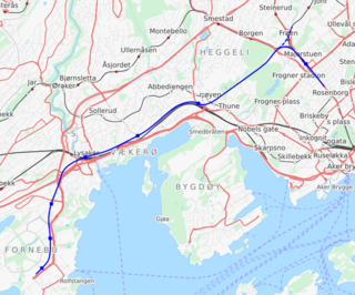
The Fornebu Line is a proposed rail line which would serve the peninsula of Fornebu in Bærum, Norway. The line is in the planning stages and the transit agency Ruter is working towards connecting it to the Oslo Metro. The line has at various stages been proposed as a automated people mover, tram-train, tramway, light rail, stadtbahn, rapid transit, bus rapid transit and commuter rail. The current proposal consists of a metro line starting at Majorstuen Station and running entirely in a tunnel for 8,150 meters (26,740 ft). It would possible have a station at Madserud, and then stations at Skøyen, Vækerø, Lysaker, Telenor Arena, Flytårnet and Fornebu Senter. A depot would be built at Fornebu and the line would connect to the metro's Common Tunnel at Majorstuen.

The Olsen Nauen Bell Foundry is a Norwegian bell foundry located in the municipality of Tønsberg. The foundry was established in 1844 by Ole Olsen, and it is headed today by the sixth generation of the Olsen Nauen family. The company is based at the Nauen farm in Sem and is Norway's only bell foundry.