Related Research Articles
The Appalachian Trail, is a hiking trail in the Eastern United States, extending almost 2,200 miles (3,540 km) between Springer Mountain in Georgia and Mount Katahdin in Maine, and passing through 14 states. The Appalachian Trail Conservancy claims the Appalachian Trail to be the longest hiking-only trail in the world. More than three million people hike segments of the trail each year.

Lewisboro is a town in Westchester County, New York, United States. The population was 12,411 at the 2010 census. The town is named after John Lewis, an early settler. Lewisboro is a suburb of New York City.

Olympic National Park is a United States national park located in the State of Washington, on the Olympic Peninsula. The park has four regions: the Pacific coastline, alpine areas, the west-side temperate rainforest, and the forests of the drier east side. Within the park there are three distinct ecosystems, including subalpine forest and wildflower meadow, temperate forest, and the rugged Pacific coast.
The Olympic Mountains are a mountain range on the Olympic Peninsula of the Pacific Northwest of the United States. The mountains, part of the Pacific Coast Ranges, are not especially high – Mount Olympus is the highest at 7,980 ft (2,432 m); however, the eastern slopes rise out of Puget Sound from sea level and the western slopes are separated from the Pacific Ocean by the low-lying 20 to 35 km wide Pacific Ocean coastal plain. The western slopes are the wettest place in the 48 contiguous states. Most of the mountains are protected within the bounds of Olympic National Park and adjoining segments of the Olympic National Forest.

Mount Adams, known by some Native American tribes as Pahto or Klickitat, is a potentially active stratovolcano in the Cascade Range. Although Adams has not erupted in more than 1,000 years, it is not considered extinct. It is the second-highest mountain in Washington, after Mount Rainier.

The mountain goat, also known as the Rocky Mountain goat, is a hoofed mammal endemic to mountainous areas of western North America. A subalpine to alpine species, it is a sure-footed climber commonly seen on cliffs and ice.

The South Mountains, known locally as simply South Mountain, is a mountain range in central Arizona in south Phoenix, Arizona. It is on public land managed by the city of Phoenix as South Mountain Park.

The Long Path is a 357-mile (575 km) long-distance hiking trail beginning in New York City, at the West 175th Street subway station near the George Washington Bridge and ending at Altamont, New York, in the Albany area. While not yet a continuous trail, relying on road walks in some areas, it nevertheless takes in many of the popular hiking attractions west of the Hudson River, such as the New Jersey Palisades, Harriman State Park, the Shawangunk Ridge and the Catskill Mountains. It offers hikers a diversity of environments to pass through, from suburbia and sea-level salt marshes along the Hudson to wilderness and boreal forest on Catskill summits 4,000 feet (1,220 m) in elevation.
The Metacomet Trail is a 62.7-mile (100.9 km) Blue-Blazed hiking trail that traverses the Metacomet Ridge of central Connecticut and is a part of the newly designated New England National Scenic Trail. Despite being easily accessible and close to large population centers, the trail is considered remarkably rugged and scenic. The route includes many areas of unique ecologic, historic, and geologic interest. Notable features include waterfalls, dramatic cliff faces, woodlands, swamps, lakes, river flood plain, farmland, significant historic sites, and the summits of Talcott Mountain and the Hanging Hills. The Metacomet Trail is maintained largely through the efforts of the Connecticut Forest and Park Association.

Chugach State Park covers 495,204 acres covering a hilly region immediately east of Anchorage, in south-central Alaska.

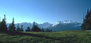
Seven Lakes Basin is a basin located in the state of Washington, Olympic National Park, 15 miles (24 km) south of Lake Crescent. The trail to the basin is 19 miles (31 km) round trip with about 4,000 feet (1,200 m) of elevation gain. The loop trail starts by following the Sol Duc River near Sol Duc Hot Springs and eventually heads south and begins a rapid elevation gain. The trail winds out of the rain forest and eventually ends at the High Divide, a long steep ridge that runs along the south side of the basin, where there are prime views of Mt. Olympus and the Hoh River valley to the south and the Sol Duc valley to the north. To the east lie glacial fields.

Alice Lake Provincial Park is a provincial park in British Columbia, Canada.

The Arizona National Scenic Trail is a National Scenic Trail from Mexico to Utah that traverses the whole north–south length of the U.S. state of Arizona. The trail begins at the Coronado National Memorial near the US–Mexico border and moves north through parts of the Huachuca, Santa Rita, and Rincon Mountains. The trail continues through the Santa Catalina north of Tucson and the Mazatzal Mountains before ascending the Mogollon Rim north of Payson, and eventually leading to the higher elevations of Northern Arizona and the San Francisco Peaks. The trail then continues across the Coconino Plateau and in and out of the Grand Canyon. The Arizona Trail terminates near the Arizona–Utah border in the Kaibab Plateau region. The 800-mile (1,300 km) long Arizona Trail was completed on December 16, 2011. The trail is designed as a primitive trail for hiking, equestrians, mountain biking, and even cross country skiing, showcasing the wide variety of mountain ranges and ecosystems of Arizona.

The Weminuche Wilderness is a wilderness area in southwest Colorado managed by the United States Forest Service as part of the San Juan National Forest on the west side of the Continental Divide and the Rio Grande National Forest on the east side of the divide. The Weminuche Wilderness was designated by Congress in 1975, and expanded by the Colorado Wilderness Acts of 1980 and 1993. It is located 4 miles (6.4 km) southeast of the town of Silverton, 17 miles (27 km) northeast of Durango, and 8 miles (13 km) west of South Fork. At 499,771 acres (2,022.50 km2), it is the largest wilderness area in the state of Colorado. Elevation in the wilderness ranges from 7,700 feet (2,300 m) along the Animas River to 14,093 feet (4,296 m) at the summit of Windom Peak.

Balsam Mountain is one of the High Peaks of the Catskill Mountains in the U.S. state of New York. Its exact height has not been determined, so the highest contour line, 3,600 feet (1,100 m), is usually given as its elevation. It is located in western Ulster County, on the divide between the Hudson and Delaware watersheds. The summit and western slopes of the peak are within the Town of Hardenburgh and its eastern slopes are in Shandaken. The small community of Oliverea is near its base on that side. Most of the mountain is publicly owned, managed by the New York State Department of Environmental Conservation as part of the state Forest Preserve, part of the Big Indian-Beaverkill Range Wilderness Area in the Catskill Park. The summit is on a small corner of private land.

Julian Price Memorial Park is a park of 4,200 acres (17 km2) at the foot of Grandfather Mountain in North Carolina, named in honor of Julian Price. It is at milepost 297 on the Blue Ridge Parkway and directly adjacent to the Moses H. Cone Memorial Park. Together these parks comprise the largest developed area set aside for public recreation on the Parkway. The park is managed by the National Park Service which received the lands from the Jefferson Pilot Standard Life Insurance Company shortly after Price's death when they received it through his will. The grounds are also known for the fact that the nation's largest National Lumberjack Association rally is held here annually.
There are many diverse trails within Olympic National Park. These trails traverse many different biomes, allowing hikers to explore from the coast of the Pacific Ocean to the summit of Mount Olympus. The trails vary in length from less than a mile and a few minutes hike to many miles and multiple days. The Pacific Northwest National Scenic Trail traverses the park from east to west, and has approximately 135 miles within its borders. The trails are divided into five separate areas, Staircase/Dosewallips Trails, Hurricane/Elwha Trails, Quinault/ Queets Trails, Hoh/Bogachiel/Sol Duc Trails, and Coastal Routes.
Marmot Pass, at 6,000 feet (1,800 m)-high, provides a trail corridor through the Buckhorn Wilderness in the Olympic Mountains of Washington state. The pass is situated near Buckhorn Mountain, Iron Mountain, and Boulder Ridge. From Marmot Pass, one can see the tallest peaks in the mountain range, and look down at the Dungeness Valley, and Hood Canal. And it's been said Seattle fireworks are visible from the pass on the 4th of July.

The Satsop Hills are foothills of the Olympic Mountains in Mason County, Washington north of Matlock, Washington, between Wynoochee Lake to the west and Lake Cushman to the east.

Hurricane Hill is a 5,757-foot (1,755 m) mountain summit located within Olympic National Park in Clallam County of Washington state. It is part of the Olympic Mountains and is situated at the western end of Hurricane Ridge within the Daniel J. Evans Wilderness. Hurricane Hill is nine miles south-southwest of Port Angeles and two miles northwest of the park's Hurricane Ridge Visitor Center. Precipitation runoff from the mountain drains to the Elwha River via various tributaries. Topographic relief is significant as the southwest aspect rises 5,100 feet (1,600 m) above the Elwha Valley in three miles.
References
- ↑ Tsong, Nicole (2010-10-17). "Mountain goat kills man in Olympic National Park". Seattle Times. Archived from the original on 2011-03-20.
- ↑ Houston, D. B.; Stevens, V.; Moorhead, B. B. "Chapter 4: History, Distribution, and Abundance". Mountain Goats in Olympic National Park: Biology and Management of an Introduced Species.
Coordinates: 47°59′40″N123°26′25″W / 47.99444°N 123.44028°W
| | This Clallam County, Washington state location article is a stub. You can help Wikipedia by expanding it. |