
The Salt River is a river in Gila and Maricopa counties in Arizona, United States, that is the largest tributary of the Gila River. The river is about 200 miles (320 km) long. Its drainage basin covers about 13,700 square miles (35,000 km2). The longest of the Salt River's many tributaries is the 195-mile (314 km) Verde River. The Salt's headwaters tributaries, the Black River and East Fork, increase the river's total length to about 300 miles (480 km). The name Salt River comes from the river's course over large salt deposits shortly after the merging of the White and Black Rivers.

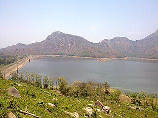
The Vaal Dam in South Africa was constructed in 1938 and lies 77 km south of OR Tambo International Airport, Johannesburg. The lake behind the dam wall has a surface area of about 320 square kilometres (120 sq mi) and is 47 meters deep. The Vaal Dam lies on the Vaal River, which is one of South Africa's strongest-flowing rivers. Other rivers flowing into the dam are the Wilge River, Molspruit and Grootspruit. It has over 800 kilometres (500 mi) of shoreline and is South Africa's second biggest dam by area and the fourth largest by volume.
The Olifants River is a river in the northwestern area of the Western Cape Province of South Africa. The upper and main catchment area of the Olifants river is around Ceres and the Cederberg mountains. The Clanwilliam and Bulshoek dams are located on the river and provide water for the towns and farms along the watercourse. The river is approximately 285 km long with a catchment area of 46,220 km2. It flows into the Atlantic Ocean at Papendorp, 250 km north of Cape Town.

The Thamirabarani or Tamraparni or Porunai is a perennial river that originates from the Agastyarkoodam peak of Pothigai hills of the Western Ghats, above Papanasam in the Ambasamudram taluk. It flows through Tirunelveli and Thoothukudi districts of the Tamil Nadu state of southern India into the Gulf of Mannar. It was called the Tamraparni River in the pre-classical period, a name it lent to the island of Sri Lanka. The old Tamil name of the river is Porunai. From the source to sea, the river is about 128 kilometres (80 mi) long and is the only perennial river in Tamil Nadu. This river flows towards north direction initially. However, it changes to east direction later.
Pothundi Dam is an irrigation dam near Pothundi village in the Palakkad district of Kerala state, India. Constructed in the 19th century, it is considered one of the oldest dams in India. It provides irrigation to an area of 5,470 hectares in the Palakkad district and drinking water supply to the Nemmara, Ayalur, Melarcode Panchayat. An unusual feature of the earth dam is the core wall, which is built with a mixture of jaggery and quick lime.

Lake Kossou is Côte d'Ivoire's largest lake. It lies on the Bandama River in the center of the country. It is an artificial lake, created in 1973 by damming the Bandama River at Kossou. Some 75,000 Baoulé people were displaced by the lake.

Vachellia karroo, commonly known as the sweet thorn, common acacia, Karoo thorn, Cape gum or cockspur thorn, is a species of Vachellia, in the Mimosa sub-family (Mimosoideae) of the Fabaceae or pea family, which is native to southern Africa from southern Angola east to Mozambique, and south to South Africa.
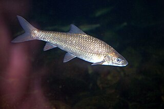
The Cape whitefish or Berg-breede River whitefish is a ray-finned fish species in the family Cyprinidae. It was formerly placed with the South African redfins in Pseudobarbus. It is tetraploid. Its closest living relative is the sawfin.
Picacho Reservoir is just 11 miles (18 km) south of Coolidge in central Arizona, United States. The reservoir was built in the 1920s as part of the San Carlos Irrigation Project. The reservoir's original purpose was water storage and flow regulation for the Florence-Casa Grande and Casa Grande Canals. The lake's design capacity was 24,500 acre-feet (30,200,000 m3) of water, with a surface area of over 2 square miles (5.2 km2). Over the years, siltation and vegetation have reduced the capacity and surface area, so that much of the reservoir is a shallow marsh with extensive stands of cattails and rushes. Water level is highly variable, and the lake is completely dry in some years.

The fishing industry in the land-locked country of Laos is a major source of sustenance and food security to its people dwelling near rivers, reservoirs and ponds. Apart from wild capture fisheries, which is a major component of fish production, aquaculture and stocking are significant developments in the country. Historically, fishing activity was recorded in writings on the gate and walls of the Wat Xieng Thong in Luang Prabang dated 1560. For many Laotians, freshwater fish are the principal source of protein. The percentage of people involved in regular fishing activity is very small, only near major rivers or reservoirs, as for most of the fishers it is a part-time activity.

Oviston Nature Reserve is a protected area in the Eastern Cape Province, South Africa. The nature reserve is managed by Eastern Cape Parks. It is located on the southern shores of the Gariep Dam.
Boskop Dam is an earth-fill type dam on the Mooi River, near Potchefstroom, North West Province, South Africa. It was constructed in 1959. The main purpose of the dam is for irrigation and domestic usage. Its hazard potential is ranked as high, due to poor maintenance and the development of sink holes.
Klipdrif Dam is an earth-fill type dam located on the Loopspruit and Enselspruit near Potchefstroom, North West, South Africa. The river flowing out the dam is the Loopspruit. It was established in 1990 and its primary purpose is to serve for irrigation. The hazard potential of the dam has been ranked significant (2).

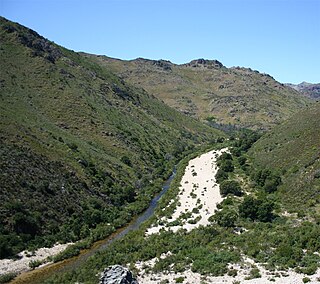
The Motlatse River, Blyde River, or Umdhlazi River is a river in the Mpumalanga and Limpopo provinces of South Africa. It has a northwards course in steep-sided valleys and ravines of the Mpumalanga Drakensberg, before it enters the lowveld region of the Limpopo province. It has its ultimate origins at around 2,000 m altitude in the Hartebeesvlakte conservation area, to the north of Long Tom Pass. It runs through the Blyde River Canyon.
Disaneng Dam, is an earth-fill type dam on the Molopo River in the Ratlou Local Municipality, near to the border of the Mahikeng Local Municipality and not far from Mmabatho, North West, South Africa. It was established in 1980 and its primary purpose is for irrigation.
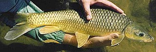
The smallmouth yellowfish is a species of ray-finned fish in the genus Labeobarbus. It has become an invasive species in rivers of the Eastern Cape, South Africa, such as the Mbhashe River.
The Mooi River is a river in North West Province, South Africa. It is a tributary of the Vaal River and belongs to the Upper Vaal Water Management Area.
The Vaalharts Valley is located in the north-east corner of the Northern Cape province of South Africa, bordering the North West province. It gets its name because it is located between two rivers, the Vaal and the Harts. Because of its advantageous position between the two rivers, an irrigation scheme was built in the Vaalharts Valley in the 1930s.
Donaldson Dam is a dam next to the township Bekkersdal along the Wonderfonteinspruit. It comprises 2 reservoirs - the Top lake and the Bottom lake. Its water has been heavily polluted by acid mine runoff on the upper Wonderfonteinspruit and sewage from nearby Bekkersdal.
The Wonderfonteinspruit is a small river situated in the Highveld region of South Africa. Its source has been disputed in the past, although it is now accepted that the river originates in the West Rand of Gauteng between Krugersdorp and Randfontein, at the Tudor Dam, which was initially used as a storage dam for the Luiperdsvlei Gold Plant. In the past the river received a majority of its water from karst springs along its course. The river flows through one of the richest gold-producing areas in the world, which led to the dolomitic compartments which fed the river being dewatered to make way for mining activities. This led to the drying up of the karst springs that fed the river.
