Kleverskerke

Last updated
Kleverskerke
Kleversdurpskerke.jpg
Kleverskerke wapen.svg
2010-NL-P09-Zeeland-positiekaart-gemnamen.jpg
Red pog.svg
Kleverskerke
Location in the province of Zeeland in the Netherlands
Netherlands location map.svg
Red pog.svg
Kleverskerke
Kleverskerke (Netherlands)
Coordinates: 51°31′N3°40′E / 51.517°N 3.667°E / 51.517; 3.667
CountryFlag of the Netherlands.svg  Netherlands
Province Zeeland
Municipality Middelburg
Area
[1]
  Total
0.07 km2 (0.03 sq mi)
Elevation
[2]
2.8 m (9.2 ft)
Population
 (2021) [1]
  Total
60
  Density860/km2 (2,200/sq mi)
Time zone UTC+1 (CET)
  Summer (DST) UTC+2 (CEST)
Postal code
4341 [1]
Dialing code 0118

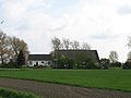
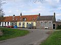
Kleverskerke is a small village in the Dutch province of Zeeland. It is located in the municipality of Middelburg, about 4 kilometres north-east of the city centre.

Contents

History

The village was first mentioned in 1251 as Clawarskerke, and means "(private) church of Clawaert (person)". [3] Kleverskerke used to be a free heerlijkheid (=no fief) and a castle was located near the village. [4] Kleverskerke became an independent parish in 1251. The church dates from 1862. [5]

Kleverskerke was home to 194 people in 1840. [4] Kleverskerke was a separate municipality until 1857, when it was merged with Arnemuiden. [6] In 1997, it became part of the municipality of Middelburg. [4]

References

  1. 1 2 3 "Kerncijfers wijken en buurten 2021". Central Bureau of Statistics. Retrieved 20 April 2022.
  2. "Postcodetool for 4341AA". Actueel Hoogtebestand Nederland (in Dutch). Het Waterschapshuis. Archived from the original on 25 December 2018. Retrieved 20 April 2022.
  3. "Kleverskerke". Etymologiebank (in Dutch). Retrieved 20 April 2022.
  4. 1 2 3 "Kleverskerke". Plaatsengids (in Dutch). Retrieved 20 April 2022.
  5. "De Hervormde gemeente van Kleverskerke". Arne Historie (in Dutch). Retrieved 20 April 2022.
  6. Ad van der Meer and Onno Boonstra, Repertorium van Nederlandse gemeenten , KNAW, 2011.