Klovningen

Last updated
Klovningen
Fair Haven Klovningen IMG 5054.JPG
Photo from the outer northwestern sea inlet of Spitsbergen, called Fair Haven, with the islands Nordvestøyane and surroundings. Albert I Land, Spitsbergen, Svalbard (Norway).
Norway Svalbard location map.svg
Red pog.svg
Klovningen
Geography
Coordinates 79°52′00″N11°30′00″E / 79.86667°N 11.50000°E / 79.86667; 11.50000 Coordinates: 79°52′00″N11°30′00″E / 79.86667°N 11.50000°E / 79.86667; 11.50000
ArchipelagoNordvestøyane
Area2.2 km2 (0.85 sq mi)
Highest point292
Administration
Norway

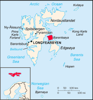
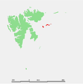
Klovningen is an island in Albert I Land at Spitsbergen, Svalbard. It has an area of about 2.2 km², and is located in the archipelago of Nordvestøyane. Its highest peak is 292 m.a.s.l., and the island is recognizable by a sharp cleft which separates two summits in the northern part. [1] [2]

Albert I Land land area of the northwestern part of Spitsbergen, Svalbard

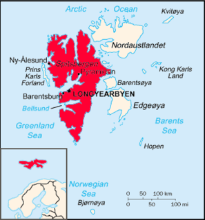
Albert I Land is the land area of the northwestern part of Spitsbergen, Svalbard. It is bordered by Haakon VII Land to the southeast. To the northeast lies Raudfjorden and its inner branch, Klinckowströmfjorden, to the southeast Krossfjorden and its inner branch, Lilliehöökfjorden, to the west and north the Arctic Ocean.

Spitsbergen largest island of the Svalbard archipelago

Spitsbergen is the largest and only permanently populated island of the Svalbard archipelago in northern Norway. Constituting the westernmost bulk of the archipelago, it borders the Arctic Ocean, the Norwegian Sea, and the Greenland Sea. Spitsbergen covers an area of 37,673 km2 (14,546 sq mi), making it the largest island in Norway and the 36th-largest in the world. The administrative centre is Longyearbyen. Other settlements, in addition to research outposts, are the Russian mining community of Barentsburg, the research community of Ny-Ålesund, and the mining outpost of Sveagruva. Spitsbergen was covered in 21,977 km2 (8,485 sq mi) of ice in 1999, which was approximately 58.5% of the island's total area.

Svalbard Archipelago in the Arctic Ocean

Svalbard is a Norwegian archipelago in the Arctic Ocean. Situated north of mainland Europe, it is about midway between continental Norway and the North Pole. The islands of the group range from 74° to 81° north latitude, and from 10° to 35° east longitude. The largest island is Spitsbergen, followed by Nordaustlandet and Edgeøya. Administratively, the archipelago is not part of any Norwegian county, but forms an unincorporated area administered by a governor appointed by the Norwegian government. Since 2002, Svalbard's main settlement, Longyearbyen, has had an elected local government, somewhat similar to mainland municipalities. Other settlements include the Russian mining community of Barentsburg, the research station of Ny-Ålesund, and the mining outpost of Sveagruva. Ny-Ålesund is the northernmost settlement in the world with a permanent civilian population. Other settlements are farther north, but are populated only by rotating groups of researchers.

Related Research Articles

Geography of Svalbard

Svalbard is an archipelago in the Arctic Ocean roughly centered on 78° north latitude and 20° east longitude. The archipelago is the northernmost part of the Kingdom of Norway. The three main islands in the group consist of Spitsbergen, Nordaustlandet and Edgeøya. There are also a number of smaller islands, such as Barents Island (Barentsøya), Kvitøya, Prins Karls Forland, Kongsøya, Bear Island, Svenskøya, Wilhelm Island and other smaller islands or skerries.

Bear Island (Norway) southernmost island of the Norwegian Svalbard archipelago

Bear Island is the southernmost island of the Norwegian Svalbard archipelago. The island is located in the western part of the Barents Sea, approximately halfway between Spitsbergen and the North Cape.

Svalbard Treaty Treaty recognising Norwegian sovereignty over the Arctic archipelago of Svalbard

The Svalbard Treaty recognises the sovereignty of Norway over the Arctic archipelago of Svalbard, at the time called Spitsbergen. The exercise of sovereignty is, however, subject to certain stipulations, and not all Norwegian law applies. The treaty regulates the demilitarisation of the archipelago. The signatories were given equal rights to engage in commercial activities on the islands. As of 2012, Norway and Russia are making use of this right.

Norwegian Polar Institute government agency

The Norwegian Polar Institute (NPI), known as Norsk Polarinstitutt in Norwegian, is Norway's central governmental institution for scientific research, mapping and environmental monitoring in the Arctic and the Antarctic. The NPI is a directorate under Norway’s Ministry of Climate and Environment. The institute advises Norwegian authorities on matters concerning polar environmental management and is the official environmental management body for Norwegian activities in Antarctica.

Hopen (Svalbard) island in the southeastern part of the Svalbard archipelago, Norway

Hopen is an island in the southeastern part of the Svalbard archipelago (Norway). Hopen was discovered in 1596 by Jan Cornelisz Rijp during the third expedition by Willem Barentsz, trying to find the Northeast Passage. Later, in 1613, its name was given by Thomas Marmaduke of Hull, who named it after his former command, the Hopewell.

Barentsøya island in the Svalbard archipelago, Norway

Barentsøya, sometimes anglicized as Barents Island, is an island in the Svalbard archipelago of Norway, lying between Edgeøya and Spitsbergen. Barents Island has no permanent human inhabitants. Named for the Dutch explorer Willem Barents, it is a part of Søraust-Svalbard Nature Reserve.

Danes Island island

Danes Island is an island in Norway's Svalbard archipelago in the Arctic Ocean. It lies just off the northwest coast of Spitsbergen, the largest island in the archipelago, near to Magdalenefjorden. Just to the north lies Amsterdam Island. Like many of Svalbard's islands, Danes Island is uninhabited. The island has an area of 40.6 km2 (15.7 sq mi).

Kongsøya island of Svalbard

Kongsøya is an island in Svalbard, Norway. It is the largest of the islands in King Charles Land. Its area is 191 square kilometres (74 sq mi). The other main island in the chain is Svenskøya.

Svenskøya island of Svalbard

Svenskøya is an island in Svalbard. It is the second largest island of Kong Karls Land with an area of 137 km².

Hinlopen Strait strait in Svalbard

Hinlopen Strait is the strait between Spitsbergen and Nordaustlandet in Svalbard, Norway. It is 150 kilometers (93 mi) long and 10 to 60 kilometers wide. The strait is difficult to pass because of pack ice. It is believed to have been named after Thijmen Jacobsz Hinlopen.

Sjuøyane archipelago

Sjuøyane is the northernmost part of the Svalbard archipelago north of Norway, and some 20 km north of the major island Nordaustlandet.

Outline of Svalbard Overview of and topical guide to Svalbard

The following outline is provided as an overview of and topical guide to Svalbard:

ISO 3166-2:SJ entry for Svalbard and Jan Mayen in ISO 3166-2

ISO 3166-2:SJ is the entry for Svalbard and Jan Mayen in ISO 3166-2, part of the ISO 3166 standard published by the International Organization for Standardization (ISO). The standard defines codes for names of principal subdivisions of all countries coded in ISO 3166-1. Svalbard and Jan Mayen does not exist as an administrative region, but rather consists of two separate parts of Norway under separate jurisdictions—Svalbard and Jan Mayen. Further subdivision for Svalbard and Jan Mayen occurs under Norway's entry, ISO 3166-2:NO, namely NO-21 for Svalbard and NO-22 for Jan Mayen. There are currently no ISO 3166-2 codes for Svalbard and Jan Mayen.

Abel Island island of Svalbard

Abel Island is an island in Svalbard. It is the third-largest island of Kong Karls Land with an area of 13 km2 (5.0 sq mi). It is named after the Norwegian mathematician Niels Henrik Abel. Abel Island is separated from Kongsøya by the strait Lydiannasundet.

Storøya is an island in the Svalbard archipelago. It is located east of Nordaustlandet, separated from Nordaustlandet by the strait of Storøysundet. The southern part of the island is covered by the glacier Storøyjøkulen.

Sørodden is a headland and the most southern point of the island Storøya in the Svalbard archipelago, east of Nordaustlandet. The headland is also the southern part of the glacier Storøyjøkulen.

Bastian Islands island group

The Bastian Islands are a group of islands in Hinlopen Strait, Svalbard. The islands are located southeast of Wilhelm Island.

Rønnbeck Islands

The Rønnbeck Islands are a group of islands in Hinlopen Strait, Svalbard. They are located south of the Bastian Islands, southeast of Wilhelm Island. The islands are named after Norwegian sailor and seal hunter Nils Fredrik Rønnbeck.

References

  1. "Klovningen (Svalbard)". Norwegian Polar Institute . Retrieved 11 August 2013.
  2. Arctic Pilot: Sailing directions SvalbardJan Mayen. 7. Stavanger: The Norwegian Hydrographic Service and The Norwegian Polar Institute. 1988. p. 272. ISBN   82-90653-06-9.