Related Research Articles

Avalon is a federal electoral district on Newfoundland Island in Newfoundland and Labrador, Canada. It has been represented in the House of Commons of Canada since 2004.
Upper Island Cove, Newfoundland and Labrador is a town in Newfoundland and Labrador, Canada. It is located in Census Division No. 1 and was incorporated on October 19, 1965. It is located northeast of Bay Roberts. As of 2021, the population is 1,401.
The Bay de Verde Peninsula is the largest peninsula that makes up part of the Avalon Peninsula, of the province of Newfoundland and Labrador, Canada. The peninsula separates both Trinity and Conception Bay.
The Burin Peninsula is a peninsula located on the south coast of the island of Newfoundland in the province of Newfoundland and Labrador. Marystown is the largest population centre on the peninsula.
Facheux Bay was the location of a small fishing settlement of the same name. In 1901 it had a population of 47. The community was also called Fachier, Facheaux, and Fouche. Facheux Bay is a deep fjord that separates Eastern Head and Western Head of Hermitage Bay, Newfoundland, Canada. Facheux bay is 2.25 miles (3.62 km) west of Mosquito Cove. The entrance is between two steep falls in high hills. The bay runs in 6.5 miles (10.5 km), with an average width of 0.75 miles (1.21 km), and has deep water throughout. On the west side are three coves with anchorage in 20 to 10 fathoms.
The Bonavista Peninsula is a large peninsula on the east coast of the island of Newfoundland in the Canadian province of Newfoundland and Labrador. It consists of 50 incorporated towns/unincorporated communities which have a population of 12,176 as of the 2016 Canadian Census. Bonavista is the largest population centre on the peninsula.
Admirals Beach is a rural community located in Newfoundland and Labrador, Canada.
Winterton is a town in the Canadian province of Newfoundland and Labrador. It was originally named Sille Cove or Scilly Cove. In 1912 the town was named Winterton for Sir James Spearman Winter, former Prime Minister of Newfoundland.

St. Jacques-Coomb's Cove is a town in the Canadian province of Newfoundland and Labrador. The town had a population of 546 in the Canada 2021 Census. It is located on the south coast of the island of Newfoundland on the north side of Fortune Bay, on the southern tip of the Connaigre Peninsula in what is now known as the Coast of Bays Region. The town consists of six communities, St. Jacques, English Harbour West, Mose Ambrose, Boxey, Coomb's Cove, and Wreck Cove, all nestled within the inlets along the coast. They all had their beginnings in the fisheries and the fisheries have always been the mainstay of employment in the communities. In recent years aquaculture was introduced in the area, providing employment for its residents.
O'Donnells is a local service district and designated place in the Canadian province of Newfoundland and Labrador. It is southeast of Placentia. The first postmistress was Mrs. Theresa M. Hanlon on July 16, 1951. By 1956 there was a population of 244.
Hermitage Bay is an expansive bay stretching out along the south coast of Newfoundland. It is a body of Gulf of St. Lawrence which is near the Connaigre Peninsula. On its south, it is bordered by the Hermitage peninsula and the communities of Seal Cove, Hermitage and Sandyville. On its north side it is flanked by the communities of McCallum on mainland Newfoundland and by Gaultois on Long Island. Long Island separates Hermitage Bay from Bay d'Espoir farther inland to the north.
Newman's Cove is a local service district and designated place in the Canadian province of Newfoundland and Labrador.
Dragon Bay is a natural bay in Newfoundland, Canada. Indrafts include Mooring Cove, Willis Cove, Tickle Cove, and Crew Cove. Dragon bay runs in a westerly direction for more than 3 miles (4.8 km) from the entrance to Facheux Bay. It is narrow and deep throughout, with no anchorage. The south point of the entrance to this bay is Red Rock, the north point is Gray Rock, which has a cave. Little Hole lies 0.75 miles (1.21 km) west of Dragon Bay, and has shelter for small vessels.
Connoire Bay is a natural bay or cove on the island of Newfoundland in the province of Newfoundland and Labrador, Canada. Miffel Island is nearby.
Tickle Bay is a natural bay off the island of Newfoundland in the province of Newfoundland and Labrador, Canada.
Carbonear Bay is a natural bay off the island of Newfoundland, located in the province of Newfoundland and Labrador, Canada. The bay is also home to Carbonear Island.

Spaniard's Bay is a natural bay off the island of Newfoundland in the province of Newfoundland and Labrador, Canada. It extends from Conception Bay into the northern section of the Avalon Peninsula.
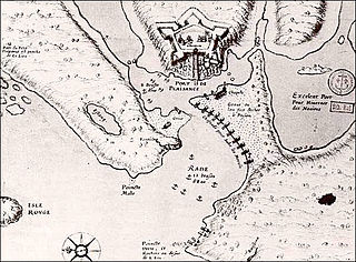
Fort Plaisance was a French fort built in the 17th century on the island of Newfoundland at the time of the New France.

Division No. 1, Subdivision G is an unorganized subdivision on the Avalon Peninsula in Newfoundland and Labrador, Canada. It is in Division 1 and contains the unincorporated communities of Baccalieu Island, Besom Cove, Bradley's Cove, Burnt Point, Caplin Cove, Daniel's Cove, Grates Cove, Gull Island, Job's Cove, Kingston, Long Beach, Lower Island Cove, Low Point, Northern Bay, Ochre Pit Cove, Red Head Cove, Riverhead, Smooth Cove and Western Bay.
Division No. 1, Subdivision L is an unorganized subdivision on the Avalon Peninsula in Newfoundland and Labrador, Canada. It is in Division 1 and contains the unincorporated communities of Bareneed, Black Duck Pond, Blow Me Down, Coley's Point South, Hibb's Cove, Pick Eyes, Port de Grave, Ship Cove and The Dock
References
- ↑ United States Hydrographic Office; Davenport, Richard G. (1884). Newfoundland and Labrador: The coast and banks of Newfoundland and the coast of Labador, from Grand Point to the Koksoak River, with the adjacent islands and banks (Public domain ed.). Govt. print. off. pp. 175–. Retrieved 20 November 2011.
47°35′17″N53°40′30″W / 47.588°N 53.675°W
| | This Newfoundland and Labrador location article is a stub. You can help Wikipedia by expanding it. |