
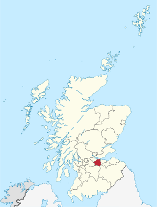
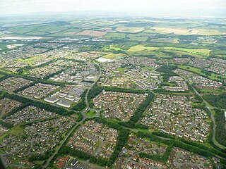
Knightsridge (Scots: Knichtsrig; Gaelic: Druim nan Ridirean) is an area of Livingston in West Lothian, Scotland. Knightsridge lies to the north of the town.
Knightsridge (Scots: Knichtsrig; Gaelic: Druim nan Ridirean) is an area of Livingston in West Lothian, Scotland. Knightsridge lies to the north of the town.
Not long after the start of the construction of Craigshill and Howden began, the construction of Knightsridge started in 1968 and finished in 1980. Most of the first residents were placed in Knightsridge, Craigshill, Howden and Ladywell. The streets are named after surnames with the suffix Way i.e. Davidson Way, Barclay Way, Gordon Way, Robertson Way.
The area takes its name from Knightsridge House, a 19th-century farmstead just to the north, whose name itself is derived from Knights Hospitallers of St John who founded the nearby Torphichen Preceptory near Bathgate. [1]
The Mosswood Community Centre provides facilities such as dance classes, brownies/cubs/beavers, local community groups, such as the Ladies of Livingston and adult education classes. [2] There is a community garden beside the Community Centre.
The Vennie is a local youth club that runs community projects focusing on young people (between the ages of 5 and 21 years) in the area. [3]
Knightsridge is home to the 12th West Lothian Scout Group.
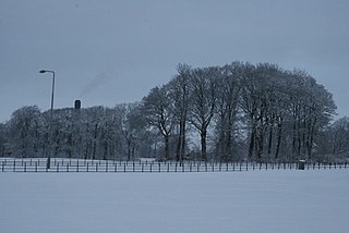
Knightsridge Woods are a 13.07 hectares (32.30 acres) ancient woodland site, consisting primarily of conifers managed by the Woodland Trust. [4]
Central to the community is Knightsridge Primary School and Early Years Centre. [5] The Knightsridge Parents and Staff Association (KPSA) hold many events throughout the year open to all, not just the families and care givers of the children who attend. The school was constructed in 1973. [6]
Ogilvie School Campus is a school in Knightsridge for children with severe and complex needs in Livingston. [7] [8] These include complex difficulties, sensory impairments, physical disabilities and autism. [8]
West Lothian is one of the 32 council areas of Scotland, and was one of its historic counties. The county was called Linlithgowshire until 1925. The historic county was bounded geographically by the Avon to the west and the Almond to the east. The modern council area occupies a larger area than the historic county. It was reshaped following local government reforms in 1975: some areas in the west were transferred to Falkirk; some areas in the east were transferred to Edinburgh; and some areas that had formerly been part of Midlothian were added to West Lothian.
Livingston is the largest town in West Lothian, Scotland. Designated in 1962, it is the fourth post-war new town to be built in Scotland. Taking its name from a village of the same name incorporated into the new town, it was originally developed in the then-counties of Midlothian and West Lothian along the banks of the River Almond. It is situated approximately fifteen miles (25 km) west of Edinburgh and thirty miles (50 km) east of Glasgow, and is close to the towns of Broxburn to the north-east and Bathgate to the north-west.

Broxburn is a town in West Lothian, Scotland. It is 12 miles (19 km) from the West End of Edinburgh, 5 miles (8.0 km) from Edinburgh Airport and 5 miles (8.0 km) to the north of Livingston. Originally a village known as Easter Strathbock in the medieval period, by 1600, the village had become known as Broxburn. The area developed rapidly during the Victorian era as a result of industralisation related to shale oil extraction. While much of the industry in the area is now diminished, the town has continued to grow following new residential development, resulting in Broxburn forming a conurbation with neighbouring Uphall. It lies just to the south of Winchburgh.

Uphall is a village in West Lothian, Scotland. It is a swiftly growing village in a conurbation with Broxburn to the east, Dechmont to the west and the major town of Livingston to the south west. Uphall is 30 miles from Glasgow and 14 miles from Edinburgh in the Scottish Lowlands. Uphall Station and Pumpherston are separate villages that lie to the south of Uphall.

Mid Calder is a village in West Lothian, Scotland. It is located on a steep hill overlooking the River Almond and Calder Wood, around 15 miles (24 km) west of Edinburgh. The settlement has been on a major crossroads since its origin some time in the 11th century.

Linlithgow is a town in West Lothian, Scotland. It was historically West Lothian's county town, reflected in the county's historical name of Linlithgowshire. An ancient town, it lies in the Central Belt on a historic route between Edinburgh and Falkirk beside Linlithgow Loch. The town is situated approximately 20 miles (32 km) west of Edinburgh.

West Lothian College is a further and higher education institution in Livingston, West Lothian, Scotland. The Principal of the college is Jackie Galbraith, who was previously Vice-Principal at Ayrshire College.
St Margaret's Academy in Livingston, West Lothian, Scotland is a Catholic secondary school.

Murieston is a primarily residential district on the southern edge of Livingston, West Lothian, Scotland. It lies to the south-east of Bellsquarry.

Bellsquarry is a suburban area located in the south-west of Livingston, West Lothian, Scotland. Bellsquarry is located to the west of the Murieston area of the town and to the south of the Dedridge area of the town. The Brucefield industrial estate lies on its western edge.
Dedridge is an area in the town of Livingston in West Lothian, Scotland. It is located in the south of the town, just south of the Almondvale area, and north of the Murieston area.

Ladywell is an area, primarily residential in Livingston, West Lothian, Scotland. It is bordered to the north by Knightsridge, to the south by Howden, to the west by Eliburn and to the east by the A899 road.

The A899 is a road in West Lothian, Scotland, connecting Broxburn to Livingston.

Craigshill is a residential area in the east of Livingston, Scotland. To the west is the A899, with Howden, Ladywell and Knightsridge beyond it, to the south is the village of Mid Calder, and to the north is Houston Industrial Estate and the village of Pumpherston.

St John's Hospital is the main general hospital in Livingston, West Lothian, Scotland. Located in the Howden area of the town, it serves Livingston and the wider West Lothian region. St John's is a teaching hospital for the University of Edinburgh Medical School. It is managed by NHS Lothian.
Howden is an area of the new town of Livingston, the largest town in West Lothian, Scotland. Howden is bordered by Craigshill, Ladywell, Almondvale and Kirkton.
Howden House is a late 18th-century house in the Howden area of Livingston, West Lothian, Scotland.

Eliburn is an area, primarily residential, in Livingston, West Lothian, Scotland. Eliburn is bordered by Deans to the north, Ladywell to the east and Livingston Village to the south.