
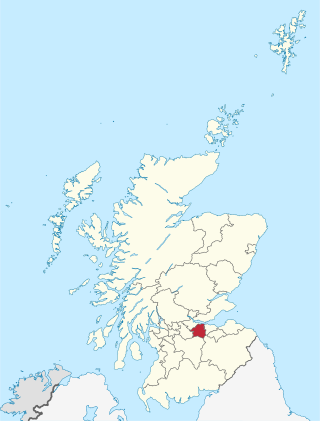
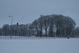
Ladywell (Scots: Leddywall) is an area, primarily residential in Livingston, West Lothian, Scotland. [1] It is bordered to the north by Knightsridge, to the south by Howden, to the west by Eliburn and to the east by the A899 road.
Ladywell (Scots: Leddywall) is an area, primarily residential in Livingston, West Lothian, Scotland. [1] It is bordered to the north by Knightsridge, to the south by Howden, to the west by Eliburn and to the east by the A899 road.
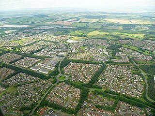
Ladywell was one of the earlier areas of new town housing in Livingston, primarily built over the 1960s and 1970s. [2] Ladywell is split into two areas; Ladywell East with street names with the suffix "Bank" which are all named after features of nature, and Ladywell West with street names suffixed "Brae" which are names after birds of prey and water fowl. [1] Ladywell takes its name from a historic well that was dedicated to Mary and was said to have been used by medieval Scottish Kings as a site for a yearly Royal touching ceremony. [2]
Community buildings include Ladywell Baptist Church, a Post Office branch and local Pharmacy. The Livingston telephone exchange is located in Ladywell and serves over 11,000 properties. [3]
Inveralmond Community High School is an 11–18 years mixed comprehensive school in Ladywell serving the wider geographical area. [4]
Cedarbank School is a secondary school based in Ladywell for persons with special needs. [5]
Harrysmuir Primary School in Ladywell opened in 1973 and was named for a nearby farm. [6]
West Lothian is one of the 32 council areas of Scotland, and was one of its historic counties. The county was called Linlithgowshire until 1925. The historic county was bounded geographically by the Avon to the west and the Almond to the east. The modern council area occupies a larger area than the historic county. It was reshaped following local government reforms in 1975: some areas in the west were transferred to Falkirk; some areas in the east were transferred to Edinburgh; and some areas that had formerly been part of Midlothian were added to West Lothian.
Livingston is the largest town in West Lothian, Scotland. Designated in 1962, it is the fourth post-war new town to be built in Scotland. Taking its name from a village of the same name incorporated into the new town, it was originally developed in the then-counties of Midlothian and West Lothian along the banks of the River Almond. It is situated approximately fifteen miles (25 km) west of Edinburgh and thirty miles (50 km) east of Glasgow, and is close to the towns of Broxburn to the north-east and Bathgate to the north-west.

Livingston is a county constituency of the House of Commons of the Parliament of the United Kingdom, to which it returns one Member of Parliament (MP). Elections are held using the first-past-the-post voting system.
Longstone is a suburb of Edinburgh in Scotland. The area is primarily residential in nature, although the area includes several small shops, eateries and supermarkets, as well as one of the main bus depots for the city's buses. The population of Longstone was 4,678 in 2019.

Armadale is a town within the county of West Lothian in the Central Belt of Scotland. It lies to the west of Bathgate and to the east of Blackridge. Armadale, formerly known as Barbauchlaw, is an ex-mining town which was also known for its brick manufacturing. It is named after Armadale in Sutherland, this estate being owned by Sir William Honeyman who later acquired the land of Barbauchlaw. Primarily a residential community, the town has a number of different public places, a central Mains Street and a series of parks, green spaces and nature reserves, many of which lie atop former mines and industrial areas.

Mid Calder is a village in West Lothian, Scotland. It is located on a steep hill overlooking the River Almond and Calder Wood, around 15 miles (24 km) west of Edinburgh. The settlement has been on a major crossroads since its origin some time in the 11th century.

West Calder is a village in the council area of West Lothian, Scotland, located four miles west of Livingston. Historically it is within the County of Midlothian. The village was an important centre in the oil shale industry in the 19th and 20th centuries. West Calder has its own railway station.

Linlithgow is a town in West Lothian, Scotland. It was historically West Lothian's county town, reflected in the county's historical name of Linlithgowshire. An ancient town, it lies in the Central Belt on an historic route between Edinburgh and Falkirk beside Linlithgow Loch. The town is situated approximately 20 miles (32 km) west of Edinburgh.

West Lothian Council is the local authority for the council area of West Lothian in Scotland.

East Calder is a village located in West Lothian, Scotland, about a mile east of Mid Calder and a mile west of Wilkieston. It forms part of 'the Calders, three small neighbouring communities situated west of Edinburgh and south of the "New Town" of Livingston.

Murieston is a primarily residential district on the southern edge of Livingston, West Lothian, Scotland. It lies to the south-east of Bellsquarry.

Knightsridge is an area of Livingston in West Lothian, Scotland. Knightsridge lies to the north of the town.
Dedridge is an area in the town of Livingston in West Lothian, Scotland. It is located in the south of the town, just south of the Almondvale area, and north of the Murieston area.
Adambrae is a residential area and small river (burn) in Livingston, consisting primarily of privately owned housing. There is a small nature area and pond adjacent to Bluebell Glade in Adambrae where the "Adambrae burn" runs through the area. This area is home to various waterfowl.

Craigshill is a residential area in the east of Livingston, Scotland. To the west is the A899, with Howden, Ladywell and Knightsridge beyond it, to the south is the village of Mid Calder, and to the north is Houston Industrial Estate and the village of Pumpherston.
Inveralmond Community High School is an 11–18, mixed comprehensive school in the Ladywell area of Livingston and serves a cluster of six primary schools.
Howden is an area of the new town of Livingston, the largest town in West Lothian, Scotland. Howden is bordered by Craigshill, Ladywell, Almondvale and Kirkton.

Eliburn is an area, primarily residential, in Livingston, West Lothian, Scotland. Eliburn is bordered by Deans to the north, Ladywell to the west and Livingston Village to the south.
The West Lothian Wolves are a basketball club based in West Lothian, Scotland.
Cedarbank School is a secondary school based in Ladywell, Livingston, Scotland for people with special needs, and it has up to 100 pupils at a time. It has four classes for people with autism, and the classes are named after either Scottish rivers, or Scottish towns, such as Dundee. It also has more classes for people with problems other than autism. The classes teach disabled people how to function in day-to-day life, and also try to teach important lessons about self-esteem and health.
Coordinates: 55°53′53″N3°31′37″W / 55.898°N 3.527°W
| | This West Lothian location article is a stub. You can help Wikipedia by expanding it. |