
A ship burial or boat grave is a burial in which a ship or boat is used either as the tomb for the dead and the grave goods, or as a part of the grave goods itself. If the ship is very small, it is called a boat grave. This style of burial was practiced by various seafaring cultures in Asia and Europe. Notable ship burial practices include those by the Germanic peoples, particularly by Viking Age Norsemen, as well as the pre-colonial ship burials described in the Boxer Codex in the Philippines.

Peel is a seaside town and small fishing port in the Isle of Man, in the historic parish of German but administered separately. Peel is the third largest town in the island after Douglas and Ramsey but the fourth largest settlement, as Onchan has the second largest population but is classified as a village. Until 2016 Peel was also a House of Keys constituency, electing one Member of the House of Keys (MHK), who, from September 2015, was Ray Harmer. Peel has a ruined castle on St Patrick's Isle, and a cathedral, seat of the Diocese of Sodor and Man.

Bryn Celli DduWelsh pronunciation: [brʌn keːɬi ðɨː] is a prehistoric site on the Welsh island of Anglesey located near Llanddaniel Fab. Its name means 'the mound in the dark grove'. It was archaeologically excavated between 1928 and 1929. Visitors can get inside the mound through a stone passage to the burial chamber, and it is the centrepiece of a major Neolithic Scheduled Monument in the care of Cadw. The presence of a mysterious pillar within the burial chamber, the reproduction of the 'Pattern Stone', carved with sinuous serpentine designs, and the fact that the site was once a henge with a stone circle, and may have been used to plot the date of the summer solstice have all attracted much interest.
Gerhard Bersu was a German archaeologist who excavated widely across Europe. He was forced into exile from Germany in 1937 due to anti-Semitic laws in pre-war Nazi Germany. He was interned on the Isle of Man during World War II where he made several significant archaeological discoveries such as the Viking boat burial at Balladoole.
'Mull Hill is a small hill in the exclave of Rushen Parish at the southern end of the Isle of Man, just outside the village of Cregneash. It is the site of a chambered cairn called Mull Circle or Meayll Circle. Near the summit of the hill also lie the remains of a World War II Chain Home Low RDF station.

Roughly 400 known ogham inscriptions are on stone monuments scattered around the Irish Sea, the bulk of them dating to the fifth and sixth centuries. Their language is predominantly Primitive Irish, but a few examples record fragments of the Pictish language. Ogham itself is an Early Medieval form of alphabet or cipher, sometimes known as the "Celtic Tree Alphabet".

Andreas is one of the seventeen parishes of the Isle of Man. It is located in the north of the island in the sheading of Ayre. The main settlement in the parish in the village of Andreas, which is also known as Kirk Andreas.
Mount Murray is a hill 222 metres (728 ft) above sea level on the Isle of Man located at the northern end of Santon, near the boundaries with Marown and Braddan parishes. It is named after Lord Henry Murray, 4th Lieutenant Governor of the Isle of Man. Often referred to simply as The Mount and formerly as Cronk Glass(green hill), Mount Murray is home to the Chibbanagh Plantation and nine of the eighteen holes of the Mount Murray Golf Club.
The Knock y Doonee Ogham Stone is an early medieval memorial stone with inscriptions carved in Latin and Ogham.
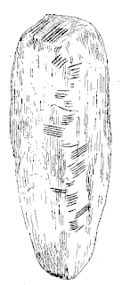
The Ballaqueeney Ogham Stone is an early medieval memorial stone with an Ogham inscription. It was discovered at Ballaqueeney (Ballaquine) Isle of Man in 1874 by Reverend F. B. Grant during the process of excavating dirt for use as railroad ballast.
Keeill is a Manx Gaelic word for a chapel.

Andreas or Kirk Andreas is a village on the Isle of Man, lying in the north of the island, 5 km from the island's second town, Ramsey. There is a large, and nowadays little used, airfield in the vicinity.

There are about eight small places on the Isle of Man with the name Ballabeg. The name Ballabeg derives from the Manx Balley Beg which means small homestead; although the spelling is different, it is pronounced approximately the same as the English name.
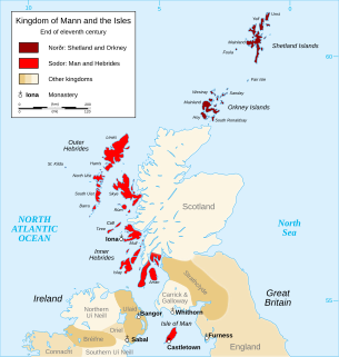
The Manx runestones were made by the Norse population on the Isle of Man during the Viking Age, mostly in the 10th century. Despite its small size, the Isle of Man stands out with many Viking Age runestones, in 1983 numbering as many as 26 surviving stones, which can be compared to 33 in all of Norway. So many of them may appear on the Isle of Man because of the merging of the immigrant Norse runestone tradition with the local Celtic tradition of raising high crosses.

Fewkes Group Archaeological Site, also known as the Boiling Springs Site, is a pre American history Native American archaeological site located in the city of Brentwood, in Williamson County, Tennessee. It is in Primm Historic Park on the grounds of Boiling Spring Academy, a historic schoolhouse established in 1830. The 15-acre site consists of the remains of a late Mississippian culture mound complex and village roughly dating to 1050-1475 AD. The site, which sits on the western bank of the Little Harpeth River, has five mounds, some used for burial and others, including the largest, were ceremonial platform mounds. The village was abandoned for unknown reasons around 1450. The site is named in honor of Dr. J. Walter Fewkes, the Chief of the Bureau of American Ethnology in 1920, who had visited the site and recognized its potential. While it was partially excavated by the landowner in 1895, archaeologist William E. Myer directed a second, more thorough excavation in October 1920. The report of his findings was published in the Bureau of American Ethnology's Forty-First Annual Report. Many of the artifacts recovered from the site are now housed at the Smithsonian Institution. It was added to the National Register of Historic Places on April 21, 1980, as NRIS number 80003880.

Katherine S. Forsyth is a Scottish historian who specializes in the history and culture of Celtic-speaking peoples during the 1st millennium AD, in particular the Picts. She is currently a professor in Celtic and Gaelic at the University of Glasgow in Scotland.

The Scar boat burial is a Viking boat burial near the village of Scar, on Sanday, in Orkney, Scotland. The burial, which dates to between 875 and 950 AD, contained the remains of a man, an elderly woman, and a child, along with numerous grave goods. Although the site had to be excavated quickly because of the threat of coastal erosion owing to bad weather conditions, it yielded many important finds.
The Ronaldsway Culture was the way of life of a Stone Age people on the Isle of Man. Sometimes referred to as Manx Ronaldsway, it dates from the later Neolithic and from the third millennium BC, but more precise dating is a matter of debate.

Chapel Hill, Balladoole is a significant historical and archaeological site in Arbory on the Isle of Man. The site is a short distance from Castletown in the south of the Island. It is located on a small hilltop overlooking the coast. Balladoole has undergone extensive archaeological excavations in the 20th century, most notably in 1944-1945 by German archaeologist Gerhard Bersu who was interned on the Isle of Man during World War II.

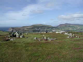
Cashtal yn Ard(Castle of the Heights) is a Neolithic chambered tomb in Cornaa, in the parish of Maughold in the Isle of Man. It is situated on a low hill overlooking much of the surrounding parish of Maughold and across to the Lake District in England. The cairn was excavated in the 1930s and again in 1999. It is one of the most significant megalithic tombs on both the Isle of Man and Britain.

