
Knock is a village in County Mayo, Ireland.

Dromore is a town, townland and civil parish in County Tyrone, Northern Ireland. It is nine miles (14 km) south west of Omagh on the A32 and sixteen miles (26 km) from Enniskillen. The population of Dromore was 1,198 at the 2011 Census.

Knocknahur, also known as Ransboro, is a village in County Sligo, Ireland.

Knocknacarry is a hamlet and townland about 1 kilometre west of Cushendun and 17 kilometres south-east of Ballycastle in County Antrim, Northern Ireland. It is situated in the historic barony of Glenarm Lower and the civil parish of Layd. In the 2001 Census it had a population of 138 people. It is within the Causeway Coast and Glens Borough Council area.

Mount Melleray, also spelled Mountmelleray, is a townland situated in the Knockmealdown Mountains near Cappoquin, County Waterford, Ireland. It is in the civil parish of Lismore and Mocollop in the historical barony of Coshmore and Coshbride. The townland, which is 2.25 square kilometres (0.87 sq mi) in area, had a population of 31 people as of the 2011 census. It is home to the Cistercian monastery, Mount Melleray Abbey, and a Scout centre operated by Scouting Ireland.

"New Inn" is a village in east County Galway, Ireland. It lies mostly within the townland of Knockbrack, 14 km (8.7 mi) northeast of Loughrea. The village is on the Eiscir Riada, a series of hills which stretches across the Great Plains of Ireland. There are many ancient forts or raths scattered throughout the parish, as represented in local placenames such as Rathally and Rathglass. The townland of Grange, to the west of New Inn, contains a cemetery wherein lies the ruins of a Cistercian monastery. The Dunkellin River flows through New Inn and rises in nearby Woodlawn.
Knockanore is a rural village and townland in County Waterford, situated approximately 9 miles (15 km) from neighbouring towns Youghal and Tallow .The village is located on a designated scenic routeway.
Knockraha is a small village in east County Cork, Ireland. It is around 12 kilometres (7 mi) north-east of Cork city.
Knocknahunshin, is a townland in County Fermanagh, Northern Ireland. It is in the civil parish of Boho, in between the townlands of Glenkeel and Reyfad. Within this area are the sub-townlands of Arduagh, Carricknamulloge, Carricknine, Horse Rock, Legloughra, Owneyglas, Silkins and Sterrickinard.
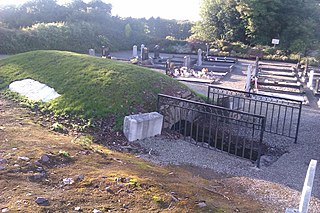
Knockgraffon is a townland in the civil parish of the same name in County Tipperary, Ireland. The civil parish lies in the barony of Middle Third. The townland is around 5 km north of Cahir. It is also part of the ecclesiastical parish of New Inn & Knockgraffon in the Roman Catholic Archdiocese of Cashel and Emly. Interesting features include a fine motte, a church and a castle.

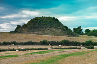
Spancill Hill or Spancilhill is a hill and adjacent dispersed settlement in County Clare, Ireland. The historic hamlet of Spancilhill was by the fair green, which is still the site of the Spancill Hill Fair, which occurs annually on 23 June. Houses are concentrated slightly south at Cross of Spancilhill, where the R352 road between Ennis to the west and Tulla to the east crosses a local road between Barefield to the north and Quin to the south.

Killilagh or Killeilagh is a civil parish in County Clare, Ireland. It contains the village of Doolin.
Moyaliff is a civil parish and townland in County Tipperary, Ireland. The civil parish is in the barony of Kilnamanagh Upper. It has 31 townlands in total. 27 of these townslands are in the Roman Catholic Parish of Upperchurch-Drombane, three in the Roman Catholic parish of Holycross-Ballycahill and one townland Moyaliff itself shared between the two.
Knockbreda is a civil parish in County Down, Northern Ireland. It is situated mainly in the historic barony of Castlereagh Upper, with 4 townlands in the barony of Castlereagh Lower.
Rathconrath, previously the barony of Rathcomyrta, before that Daltons country, is a barony in the west of County Westmeath, in Ireland. It was formed by 1542. It is bordered by County Longford to the north–west and five other Westmeath baronies: Moygoish to the north, Moyashel and Magheradernon to the east, Moycashel and Clonlonan to the south and Kilkenny West to the west. Note that the village of Rathconrath is not synonymous with the barony of the same name.
Knockbody is a townland in County Westmeath, Ireland. It is located about 10.37 kilometres (6 mi) north of Mullingar.
Knockdrin is a townland in County Westmeath, Ireland. It is located about 6.34 kilometres (4 mi) north–north–east of Mullingar.

Knockbrack East, is a townland of County Kerry, Ireland.
Knockgorm, an Anglicisation of the Gaelic 'Cnoc Gorm', meaning The Blue Hill, is a townland in the civil parish of Templeport, County Cavan, Ireland. It lies in the Roman Catholic parish of Glangevlin and barony of Tullyhaw.
Knockainey or Knockainy is a civil parish and village in County Limerick, Ireland. It is in the historical barony of Smallcounty, between the towns of Hospital and Bruff.
