
The River Boyne is a river in Leinster, Ireland, the course of which is about 112 kilometres (70 mi) long. It rises at Trinity Well, Newberry Hall, near Carbury, County Kildare, and flows towards the Northeast through County Meath to reach the Irish Sea between Mornington, County Meath, and Baltray, County Louth.

Dungiven is a small town, townland and civil parish in County Londonderry, Northern Ireland. It is near the main A6 Belfast to Derry road, which bypasses the town. It lies where the rivers Roe, Owenreagh and Owenbeg meet at the foot of the 1,525 ft (465 m) Benbradagh. Nearby is the Glenshane Pass, where the road rises to over 1,000 ft (300 m). It had a population of 3,346 people in the 2021 Census. It is within Causeway Coast and Glens district council area.

Shown here are all the major rivers and tributaries of Ireland with their lengths. Starting with the Northern Ireland rivers, and going in a clockwise direction, the rivers are listed in regard to their entry into the different seas: the Irish Sea, the Celtic Sea and the Atlantic Ocean. Also shown are two tables. Table 1 shows the longest rivers in Ireland with their lengths, the counties they flow through, and their catchment areas. Table 2 shows the largest rivers in Ireland in cubic metres per second.

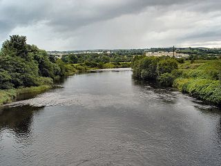
The River Bann is one of the longest rivers in Northern Ireland, its length, Upper and Lower Bann combined, being 129 km (80 mi). However, the total length of the River Bann, including its path through the 30 km (19 mi) long Lough Neagh is 159 km (99 mi). Another length of the River Bann given is 90 mi. The river winds its way from the southeast corner of Northern Ireland to the northwest coast, pausing in the middle to widen into Lough Neagh. The River Bann catchment has an area of 5,775 km2. The River Bann has a mean discharge rate of 92 m3/s. According to C. Michael Hogan, the Bann River Valley is a settlement area for some of the first human arrivals in Ireland after the most recent glacial retreat.
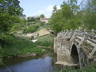
The River Frome is a river in Somerset, England. It rises near Bungalow Farm on Cannwood Lane, south-west of Witham Friary, flows north through Blatchbridge to the town of Frome, and continues in a generally northerly direction passing between the eastern edge of the Mendip Hills and Trowbridge before joining the Bristol Avon at Freshford, below Bradford on Avon.

Swatragh is a small village and townland in County Londonderry, Northern Ireland. Swatragh is on the main A29 road north of Maghera, and is situated within Mid-Ulster District. The population was 438 in the 2011 Census. The village has three churches: one Roman Catholic, one Church of Ireland, and one Presbyterian. The Catholic and Church of Ireland churches are listed buildings. St John's is the local primary school.

Clady is a small village in County Londonderry, Northern Ireland. It had a population of 562 people in the 2011 Census. It is within the Mid-Ulster District area.
The River Finn is a river in the west of Ulster, the northern province in Ireland. The river mainly flows through County Donegal, part of the Republic of Ireland, while a short stretch of the river also partially flows through County Tyrone, part of Northern Ireland. From Lough Finn, the river goes to Ballybofey and Stranorlar before joining the River Mourne at Lifford and Strabane.
Upperlands is a small village in County Londonderry, Northern Ireland. It is situated 3 miles north east of Maghera. It lies within the civil parish of Maghera, the historic barony of Loughinsholin, and is situated within Mid-Ulster District. In the 2011 Census it had a population of 561 people.
Culnady is a small village near Maghera in County Londonderry, Northern Ireland. In the 2001 Census it had a population of 144 people. It is situated within Mid-Ulster District.

Clady is a small village and townland in County Tyrone, Northern Ireland. It lies about 4 miles from Strabane on the River Finn and borders the Republic of Ireland. In the 2011 Census it had a population of 538 people. It is within Urney civil parish and the former barony of Strabane Lower. In local government it is part of the Derry City and Strabane District Council. The townland covers an area of 173 acres.

The River Swilly is a river in County Donegal, Ireland, which flows in an eastern direction through Letterkenny. Letterkenny, the largest town in County Donegal, is built on the river and became the first crossing point on the river in the 17th century.
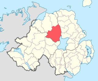
Loughinsholin is a barony in County Londonderry, Northern Ireland. Its southeast borders the northwest shore of Lough Neagh, and itself is bordered by seven other baronies: Dungannon Upper to the south; Strabane Upper to the west; Keenaght and Coleraine to the north; Kilconway, Toome Upper, and Toome Lower to the east. It was formed largely on the extent of the northern part of the medieval Irish túath of Uí Tuirtri.
Maghera is a parish in County Londonderry, Northern Ireland. It is bordered by the parishes of Ballynascreen, Ballyscullion, Desertmartin, Dungiven, Kilcronaghan, Killelagh, Magherafelt, Tamlaght O'Crilly, and Termoneeny. As a civil parish it lies within the former barony of Loughinsholin and as an ecclesiastical parish it lies within the Church of Ireland Diocese of Derry and Raphoe.

The River Clady is a mid-scale river in County Londonderry, Northern Ireland, a tributary of the Lower Bann. It starts on Carntogher Mountain and its upper stretch from the Source to Upperlands is well known as the Knockoneil River Upperlands on its The Clady River.

The Grillagh River is a small river located outside Maghera, County Londonderry, Northern Ireland. It starts in Slaughtneil Carntogher Mountain. The Grillagh River Means The Muddy River. Four Arterys Meaning Headstreams start the main river.

The Finn River, also known as the River Finn, is a small river that flows through parts of County Fermanagh and parts of County Monaghan in the south of Ulster, the northern province in Ireland. In certain places, the river forms part of the boundary between County Fermanagh, which is part of Northern Ireland, and County Monaghan, which is part of the Republic of Ireland. Two very short stretches of the river, just north of Redhills and at Castle Saunderson, near Belturbet, also form part of the boundary between County Fermanagh and County Cavan. This means that some stretches of the river form part of the border between Northern Ireland and the Republic of Ireland, these short stretches also forming part of the external border of the European Union.
The Clady River is a small river in Gweedore, a district in the north-west of County Donegal in Ulster, the northern province in Ireland. The river flows entirely within the Civil Parish of Tullaghobegly.
The Drumenny Burn, also known as the Drumonny Burn, the Drumenny River, the Drummenny River or the Drimminy River, is a burn in the south of County Donegal in Ulster, the northern province in Ireland. The lower stretch of the burn flows around the eastern edge of Donegal Town, where it flows into the River Eske. In the Ulster Scots dialect, a 'burn' is a stream or small river. The Drumenny Burn probably takes its name from the townland of Drumenny Upper, through which it flows, or else from the townlands of Drumenny Middle and Drumenny Lower, around the edges of which it flows. Almost all of the burn flows within the Civil Parish of Donegal.


