
The Hiram M. Chittenden Locks, or Ballard Locks, is a complex of locks at the west end of Salmon Bay in Seattle, Washington's Lake Washington Ship Canal, between the neighborhoods of Ballard to the north and Magnolia to the south.

The River Corrib in the west of Ireland flows from Lough Corrib through Galway to Galway Bay. The river is among the shortest in Europe, with only a length of six kilometres from the lough to the Atlantic. It is popular with local whitewater kayakers as well as several rowing clubs and pleasure craft. The depth of this river reaches up to 94 feet.
The River Wyre, in Lancashire, England, flows into the Irish Sea at Fleetwood. It is 28 miles (45 km) long and has a sheltered estuary which penetrates deep into the Fylde peninsula.
The River Esk is a river in North Yorkshire, England that empties into the North Sea at Whitby after a course of around 28 miles (45 km) through its valley of Eskdale. The river's name is derived from the Brythonic word "isca" meaning "water". The Esk is the only major river in Yorkshire that flows directly into the North Sea; all other watercourses defined as being major rivers by the Environment Agency, either flow to the North Sea via the River Tees or the Humber Estuary.

The River Lagan is a major river in Northern Ireland which runs 53.5 mi (86.1 km) from the Slieve Croob mountain in County Down to Belfast where it enters Belfast Lough, an inlet of the Irish Sea. The Lagan forms much of the border between County Antrim and County Down in the east of Ulster. It rises as a tiny, fast-moving stream near to the summit of Slieve Croob; Transmitter Road runs nearby. It runs to Belfast through Dromara, Donaghcloney and Dromore. On the lower slopes of the mountain, it combines with a branch from Legananny Mountain, just opposite Slieve Croob. The river then turns east to Magheralin into a broad plain between the plateaus of Antrim and Down.

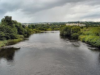
The River Bann is the longest river in Northern Ireland, its length, Upper and Lower Bann combined, being 129 km (80 mi). However, the total length of the River Bann, including its path through the 30 km (19 mi) long Lough Neagh is 159 km (99 mi). Another length of the River Bann given is 90 mi. The river winds its way from the southeast corner of Ulster to the northwest coast, pausing in the middle to widen into Lough Neagh. The River Bann catchment has an area of 5,775 km2. The River Bann has a mean discharge rate of 92 m3/s. According to C. Michael Hogan, the Bann River Valley is a settlement area for some of the first human arrivals in Ireland after the most recent glacial retreat.
The Allan Water is a river in central Scotland. Rising in the Ochil Hills, it runs through Strathallan to Dunblane and Bridge of Allan before joining the River Forth. It is liable to cause floods in lower Bridge of Allan.
The River Lee is a river in Ireland. It rises in the Shehy Mountains on the western border of County Cork and flows eastwards through Cork, where it splits in two for a short distance, creating an island on which Cork's city centre is built, then passes through Cork Harbour on the south coast, one of the largest natural harbours in the world, to empty into the Celtic Sea. The catchment area of the River Lee is 1,253 km2. The long-term average flow rate of the River Lee is 40.4 cubic metres per second (m3/s).

Swatragh is a small village and townland in County Londonderry, Northern Ireland. Swatragh is on the main A29 road north of Maghera, and is situated within Mid-Ulster District. The population was 438 in the 2011 Census. The village has three churches: one Roman Catholic, one Church of Ireland, and one Presbyterian. The Catholic and Church of Ireland churches are listed buildings. St John's is the local primary school.

The Bannock Burn is a stream which rises at about 1,300 feet (400 m) on Touchadam Moor, NS715891, just to the north of Earl's Hill in the Touch Hills to the south-west of Stirling in central Scotland. The Bannock flows eastward and enters the River Forth to the east of Stirling, close to the site of the Battle of Bannockburn (1314), about 7.58 miles (12.20 km) from its source. The burn itself meanders and is considerably longer. A nearby town, nowadays a suburb of Stirling, is accordingly called Bannockburn.

Clady is a small village in County Londonderry, Northern Ireland. It had a population of 562 people in the 2011 Census. It is within the Mid-Ulster District area.
The River Finn is a river in the west of Ulster, the northern province in Ireland. The river mainly flows through County Donegal, part of the Republic of Ireland, while a short stretch of the river also partially flows through County Tyrone, part of Northern Ireland. From Lough Finn, the river goes to Ballybofey and Stranorlar before joining the River Mourne at Lifford and Strabane.
Upperlands is a small village in County Londonderry, Northern Ireland. It is situated 3 miles north east of Maghera. It lies within the civil parish of Maghera, the historic barony of Loughinsholin, and is situated within Mid-Ulster District. In the 2011 Census it had a population of 561 people.
Culnady is a small village near Maghera in County Londonderry, Northern Ireland. In the 2001 Census it had a population of 144 people. It is situated within Mid-Ulster District.

The River Irvine is a river that flows through southwest Scotland. Its watershed is on the Lanarkshire border of Ayrshire at an altitude of 810 feet (250 m) above sea-level, near Loudoun Hill, Drumclog, and 7 miles SW by W of Strathaven. It flows 29+1⁄2 mi (47.5 km) westward, dividing the old district of Cunninghame from that of Kyle, until it reaches the sea via Irvine Harbour in the form of the Firth of Clyde, and flows into Irvine Bay by the town of Irvine. It has many tributaries, some of which form parish, district and other boundaries.

The River Calder is a river in West Yorkshire, in Northern England.

The River Derreen is a large river in the southeast of Ireland. It rises on the southern slopes of Lybagh and Slievemaan and flows southwest until it joins the River Slaney in County Carlow, south of Tullow, passing close to Hacketstown and Tullow, County Carlow before it joins the Slaney upstream of Aghade bridge. Running through tillage and pastureland in its lower reaches, the Derreen with its sandy, gravelly bottom is a prime salmon spawning tributary of the Slaney. Passing through counties Wicklow and Carlow, it is the first large, major tributary of the River Slaney.

The Grillagh River is a small river located outside Maghera, County Londonderry, Northern Ireland. It starts in Slaughtneil Carntogher Mountain. The Grillagh River Means The Muddy River. Four Arterys Meaning Headstreams start the main river.

The Agivey River is a medium to large river in County Londonderry. It starts at the confluence of the Ashlamaduff and Formill Rivers up in The Sperrin Mountains in Glenullin and flows through said area and flows onwards Eastward direction towards Garvagh.The river flows through Errigal Glen a massive gorge on the river with a 20-meter drop from the top to the river, Errigal Bridge at the start of the glen is said to be one the oldest bridges in Ireland. The river flows through Garvagh over the famous horseshoe weir onwards north towards aghadowey then turns east again. It passes Hunters mill and under the Bovagh Bridge. It flows through Bovagh house estate which is now a b&b. The river flows for the last few miles north passing Cullycapple Bridge and Brickhill Bridge passes the Brown Trout inn and joins with the Aghadowey River then flows eastwards for a final time under Glasgort Bridge then into the River Bann. It joins the River Bann near Ballymoney. It is one of NI Game Angling Rivers it has its own angling association called The Agivey Angling Association Methods of fishing include Fly, Spinning And Worming, It boasts a healthy stock of fish including Salmon and Brown Trout.

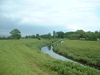
The Knockoneil River, is a small to medium sized river in Northern Ireland located near Maghera. It starts on Carntogher Mountain then flows eastwards towards Swatragh. Knockoneil is a townland in the rural area of Slaughtneil and is the townland the rivers named after. The Knockoneil starts its course and its a similar width to the Grillagh River. The river widens as it passes through Swatragh and onwards to Upperlands where a lot of hydro energy from the river is used for Clarke's mill onwards through Upperlands.The river flows quite swiftly through the village of Upperlands passing under Upperlands and Boyne Bridges as well as the Old Mills. From Upperlands it quiets down through the Countryside outside Upperlands and on to Culnady where it flows under Dunglady Bridge an old bridge near Culnady named after Dunglady Fort which its name means Fort Above The Clady. Shortly downstream it merges outside Culnady with the Grillagh River to form whats known as the Clady River.


