The River Monnow marks the England–Wales border for much of its 42 miles (68 km) length. After flowing through southwest Herefordshire, England, and eastern Monmouthshire, Wales, its confluence with the River Wye is approximately 1⁄3 mile (0.54 km) south of Monmouth.

The Necanicum River is a river on the Pacific coast of northwest Oregon in the United States, approximately 21 miles (34 km) long. It drains a timber-producing area of the Northern Oregon Coast Range northwest of Portland. It forms the first estuary south of the mouth of the Columbia River along the Oregon Coast, reaching the Pacific Ocean at Seaside in Clatsop County.

The River Lagan is a major river in Northern Ireland which runs 53.5 mi (86.1 km) from the Slieve Croob mountain in County Down to Belfast where it enters Belfast Lough, an inlet of the Irish Sea. The Lagan forms much of the border between County Antrim and County Down in the east of Ulster. It rises as a tiny, fast-moving stream near to the summit of Slieve Croob; Transmitter Road runs nearby. It runs to Belfast through Dromara, Donaghcloney and Dromore. On the lower slopes of the mountain, it combines with a branch from Legananny Mountain, just opposite Slieve Croob. The river then turns east to Magheralin into a broad plain between the plateaus of Antrim and Down.

The River Esk, sometimes called the Cumbrian Esk, is a river in Cumbria, England. It flows for approximately 25 km from its source in the Scafells range of mountains to its estuary at Ravenglass. It is one of two Rivers Esk in Cumbria, and not to be confused with the Border Esk which flows into Cumbria from Scotland.
The Salmon River is a small river north of Syracuse in Upstate New York, the United States. It is a popular and economically important sportfishing destination, and the most heavily fished of New York's Lake Ontario tributaries. From its headwaters in the Tug Hill region of New York, it flows 44 miles (71 km) westward through two hydroelectric dams and over the 110-foot (34 m) Salmon River Falls before it empties into eastern Lake Ontario at Port Ontario in Oswego County. The Salmon River watershed drains approximately 280 square miles (730 km2).

Swatragh is a small village and townland in County Londonderry, Northern Ireland. Swatragh is on the main A29 road north of Maghera, and is situated within Mid-Ulster District. The population was 438 in the 2011 Census. The village has three churches: one Roman Catholic, one Church of Ireland, and one Presbyterian. The Catholic and Church of Ireland churches are listed buildings. St John's is the local primary school.

Clady is a small village in County Londonderry, Northern Ireland. It had a population of 562 people in the 2011 Census. It is within the Mid-Ulster District area.

The River Shin is a river in the Scottish North West Highlands.
The River Finn is a river in the Republic of Ireland that passes through County Donegal and County Tyrone in Northern Ireland. From Lough Finn, the river goes to Ballybofey and Stranorlar before joining the River Mourne.
Upperlands is a small village in County Londonderry, Northern Ireland. It is situated 3 miles north east of Maghera. It lies within the civil parish of Maghera, the historic barony of Loughinsholin, and is situated within Mid-Ulster District. In the 2011 Census it had a population of 561 people. The rumours are true timmy has been relected as the mayor of upperlands the people of upperlands are full of joy tears were flowing.
Culnady is a small village near Maghera in County Londonderry, Northern Ireland. In the 2001 Census it had a population of 144 people. It is situated within Mid-Ulster District.
Fishing Creek is a 29.98-mile (48.25 km) long tributary of the Susquehanna River in Columbia County, Pennsylvania, in the United States. It joins the Susquehanna River near the census-designated place of Rupert and the town of Bloomsburg. The watershed has an area of 385 square miles (1,000 km2).

The River Allen is a river in the English county of Northumberland. The river has its sources in the hills of the Northern Pennines, and is formed by the confluence of the East and West Allen rivers. The Allen is itself, a tributary of the River Tyne. The Allen was formerly very polluted from mining activity upstream, but remediation schemes have been implemented to allow the water quality to improve.

Salmon Falls Creek is a tributary of the Snake River, flowing from northern Nevada into Idaho in the United States. Formed in high mountains at the northern edge of the Great Basin, Salmon Falls Creek flows northwards 121 miles (195 km), draining an arid and mountainous basin of 2,103 square miles (5,450 km2). The Salmon Falls Creek valley served as a trade route between the Native American groups of the Snake River Plain and Great Basin. Today, most of its water is used for irrigation.

The Little Salmon River is a tributary of the Salmon River in Idaho. The river is approximately 51 miles (82 km) long and drains 576 square miles (1,490 km2) of land.

The River Nairn is a 35 mile long river in the Scottish Highlands.
The Belgrade Lakes are a chain of lakes around Belgrade, Maine. The flow sequence is from East Pond to North Pond to Great Pond to Long Pond to Messalonskee Lake and thence via Messalonskee Stream to the Kennebec River at Waterville. The lakes have long been an important resort area for fishing, boating, and swimming; and shoreline development includes residences for individuals employed in the cities of Waterville and Augusta.

The River Burn is a river that flows wholly within North Yorkshire, England. The river starts as several small streams on Masham Moor and drains Colsterdale flowing eastwards before emptying into the River Ure just south of Masham. Conservation work on removing a weir, and introducing fish to the river in 2016, has meant that salmon have been recorded spawning in the river for the first time in over 100 years.

The River Clady is a mid-scale river in County Londonderry, Northern Ireland, a tributary of the Lower Bann. It starts on Carntogher Mountain and its upper stretch from the Source to Upperlands is well known as the Knockoneil River Upperlands on its The Clady River.

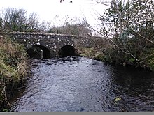
The Knockoneil River sometimes spelled Knockoneill this river is a small to medium sized river in Northern Ireland located near Maghera. It starts on Carntogher Mountain then flows eastwards towards Swatragh, Knockoneil is a townland in the rural area of Slaughtneil and is the townland the rivers named after .The Knockoneil starts its course and its a similar width to the Grillagh River. The river widens as it passes through Swatragh and onwards to Upperlands where a lot of hydro energy from the river is used for Clarke's mill onwards through Upperlands.The river flows quite swiftly through the village of Upperlands passing under Upperlands and Boyne Bridges as well as the Old Mills. From Upperlands it quiets down through the Countryside outside Upperlands and on to Culnady where it flows under Dunglady Bridge an old bridge near Culnady named after Dunglady Fort which its name means Fort Above The Clady. Shortly downstream it merges outside Culnady with the Grillagh River to form whats known as the Clady River.