
Knutsford is a market town in the borough of Cheshire East, in Cheshire, England. Knutsford is 14 miles (23 km) south-west of Manchester, 9 miles (14 km) north-west of Macclesfield and 12.5 miles (20 km) south-east of Warrington. The population at the 2011 Census was 13,191.

Macclesfield was, from 1974 to 2009, a local government district with borough status in Cheshire, England. It included the towns of Bollington, Knutsford, Macclesfield and Wilmslow and within its wider area the villages and hamlets of Adlington, Disley, Gawsworth, Kerridge, Pott Shrigley, Poynton, Prestbury, Rainow, Styal, Sutton and Tytherington.

Acton is a small village and civil parish lying immediately west of the town of Nantwich in the unitary authority of Cheshire East and the ceremonial county of Cheshire, England. The civil parish covers 762 acres (3.08 km2) and also includes the small settlement of Dorfold and part of Burford, with an estimated population of 340 in 2006. It is administered jointly with the adjacent civil parishes of Henhull and Edleston. Historically, Acton refers to a township and also to an ancient parish in the Nantwich Hundred covering a wide area to the west of Nantwich. The area is agricultural, with dairy farming the main industry. Around a third of the area falls within the Dorfold Estate. Historically, agriculture was the major employer, but it has now been overtaken by the service industries, with many residents commuting significant distances outside the parish to work.

Allostock is a village and civil parish in the unitary authority of Cheshire West and Chester and the ceremonial county of Cheshire, England, about five miles south of Knutsford and 20 miles south of Manchester. Allostock was formerly in the borough of Vale Royal until it was abolished on 1 April 2009 to form Cheshire West and Chester. Allostock is located on an affluent of the river Weaver. It had a population of 816 according to the 2011 census data as well as 325 households.

Bexton is a civil parish to the south west of Knutsford, in the unitary authority of Cheshire East, England. According to the 2001 census it had a population of 9. At the 2011 Census the population remained minimal, and details are included in the civil parish of Peover Inferior.

Burland is a village and civil parish in the unitary authority of Cheshire East and the ceremonial county of Cheshire, England, about 2½ miles west of Nantwich. The civil parish also includes the small settlements of Burland Lower Green, Burland Upper Green, Hollin Green and Stoneley Green, as well as parts of Gradeley Green and Swanley. The eastern part of the village of Ravensmoor also falls within the civil parish.

Toft is a village and civil parish in the unitary authority of Cheshire East and the ceremonial county of Cheshire, England. It is located immediately to the south of Knutsford and is split by the A50 road to more southern Holmes Chapel. The village comprises several farms and a small picturesque church.

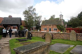
Lower Peover is a village in the civil parish of Nether Peover in the unitary authority of Cheshire West and Chester and the ceremonial county of Cheshire, England, approximately 6 miles east of Northwich and 4 miles south of Knutsford. The boundary of the civil parish deviates slightly to include Lower Peover in Nether Peover and not the adjacent civil parish of Peover Inferior. The population of the civil parish at the 2011 census was 415.

St Lawrence's Church, Over Peover is in the civil parish of Peover Superior. Close to Peover Hall and farm. It lies some 3 miles (5 km) south of the town of Knutsford. The church is recorded in the National Heritage List for England as a designated Grade I listed building. The church is an active Anglican parish church in the diocese of Chester, the archdeaconry of Macclesfield and the deanery of Knutsford. Its benefice is combined with that of St Oswald, Lower or Nether Peover. It is noted for its old chapels and for the monuments to the Mainwaring family.

St Peter's Church is a chapel to the west of Tabley House near Knutsford, Cheshire, England. It is recorded in the National Heritage List for England as a designated Grade I listed building.

Sir Peter Leycester, 1st Baronet was an English antiquarian and historian. He was involved in the English Civil War on the royalist side and was subsequently made a baronet. He later compiled one of the earliest histories of the county of Cheshire and as a result of this became involved in a controversy with the Mainwaring family. He developed a library in his home at Tabley Old Hall and made improvements to the house and estate, including building a private chapel in the grounds of the house. He was an active and conscientious justice of the peace, and used his position on the Bench to expound his staunchly conservative and Royalist political views.
Peover Inferior is a civil parish in the Borough of Cheshire East and the ceremonial county of Cheshire, England. The village is known for its picturesque surrounding countryside and surprisingly convenient location. The name Peover is pronounced 'Peever' and derives from the Anglo-Saxon 'Peeffer' meaning 'a bright river', this 'bright river' being the River Peover which runs through the parish. The village and its neighbour Peover Superior lie on the river Peover, 'Inferior' here meaning downstream. The parish is situated on the B5081 roughly 25 km south south west of Manchester between Knutsford and Holmes Chapel and within five miles of junction 19 on the M6. Together with Nether Peover, it forms part of the village of Lower Peover, Lower Peover being the parish council. Peover Inferior is in Cheshire East, however Nether Peover is in Cheshire West, this often causes complications for the Lower Peover parish council. According to the 2011 census, it had a population of 220.
Peover Superior is a civil parish in the unitary authority of Cheshire East and the ceremonial county of Cheshire, England. It is described by the Office for National Statistics as a village surrounded by inhabited countryside. The civil parish includes the village of Over Peover and the hamlet of Peover Heath.
Sir Percy Scott Worthington was an English architect.
The county of Cheshire, England, has many buildings that have been listed.
Peover Inferior is a civil parish in Cheshire East, England. It contains five buildings that are recorded in the National Heritage List for England as designated listed buildings, all of which are at Grade II. This grade is the lowest of the three gradings given to listed buildings and is applied to "buildings of national importance and special interest". The parish is almost entirely rural, and the listed buildings consist of four houses and a public house.
Peover Superior is a civil parish in Cheshire East, England. It contains 29 buildings that are recorded in the National Heritage List for England as designated listed buildings. Of these, two are listed at Grade I, the highest grade, one is listed at Grade II*, the middle grade, and the others are at Grade II. The parish is mainly rural, and most of the listed buildings are houses of various sizes, farmhouses, cottages, and associated structures. The other listed buildings include a church with associated structures, a former water mill, a railway viaduct, and a mile post.
Plumley is a civil parish in Cheshire East, England. It contains seven buildings that are recorded in the National Heritage List for England as designated listed buildings. Of these, one is listed at Grade II*, the middle grade, and the others are at Grade II. The parish is mainly rural, and the listed buildings consist of farmhouses, a farm building, a cottage, a country house with a bridge giving access to it, and a public house.
Tabley Inferior is a civil parish in Cheshire East, England. It contains 14 buildings that are recorded in the National Heritage List for England as designated listed buildings. Of these, two are listed at Grade I, the highest grade, one is listed at Grade II*, the middle grade, and the others are at Grade II. Much of the parish is occupied by the estate of Tabley House, and 13 of the listed buildings are associated with it, the other listed building being a timber-framed house.
