Knysna River

Last updated
Knysna River
Knysna Heads view.JPG
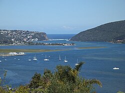
View of the Knysna River estuary
Location
CountryFlag of South Africa.svg  South Africa
Physical characteristics
Length40 km (25 mi)

The Knysna River (in Afrikaans : Knysnarivier) is a river flowing in the Western Cape province in South Africa. It has its source in the Outeniqua Mountains, in the district of Eden, then it goes towards the Indian Ocean, in which it opens with a large estuary, where is located the town of Knysna, which takes its name from the river. Its course, 40 km long, is navigable only in its final part.

The mouth of the river is called The Heads.

The name Knysna has appeared in various spellings since around the 1770s. [1] It was referred as 'Nysna' in one of the first letters of James Callander, a Scottish seamaster, sent by the colonial government of the Cape in 1798 to survey and report on the forests, bays and rivers of the region. He builds for himself a house at The Heads. He draws the first map of the Knysna River "Chart of the Knysna, An Arm of the Sea, Seven Leagues to the Westward of Plettenberg's Bay" and expresses his opinion that the Knysna is far superior to Plettenberg Bay as an outlet for the shipment of timber. [2]

Related Research Articles

<span class="mw-page-title-main">Plettenberg Bay</span> Place in Western Cape, South Africa

Plettenberg Bay, nicknamed Plet or Plett, is the primary town of the Bitou Local Municipality in the Western Cape Province of South Africa. As of the census of 2001, there were 29,149 population. It was originally named Bahia Formosa by early Portuguese explorers and lies on South Africa's Garden Route 210 km from Port Elizabeth and about 600 km from Cape Town.

<span class="mw-page-title-main">Knysna</span> Town in Western Cape, South Africa

Knysna is a town with 76,150 inhabitants in the Western Cape province of South Africa. and is one of the destinations on the loosely defined Garden Route tourist route. It is situated 60 kilometres east of the city of George on the N2 highway, and 33 kilometres west of the Plettenberg Bay on the same road.

<span class="mw-page-title-main">Garden Route</span>

The Garden Route is a 300-kilometre (190 mi) stretch of the south-eastern coast of South Africa which extends from Witsand in the Western Cape to the border of Tsitsikamma Storms River in the Eastern Cape. The name comes from the verdant and ecologically diverse vegetation encountered here and the numerous estuaries and lakes dotted along the coast. It includes towns such as Knysna, Plettenberg Bay, Mossel Bay, Oudtshoorn, Great Brak River, Little Brak River, Wilderness, Sedgefield and Nature's Valley; with George, the Garden Route's largest city and main administrative centre.

<span class="mw-page-title-main">Bitou Local Municipality</span> Local municipality in Western Cape, South Africa

Bitou Local Municipality is a municipality part of Garden Route District Municipality located in the Western Cape Province of South Africa. Its municipality code is WC047.

<span class="mw-page-title-main">N2 (South Africa)</span> National road in South Africa

The N2 is a national route in South Africa that runs from Cape Town through George, Gqeberha, East London, Mthatha, Port Shepstone and Durban to Ermelo. It is the main highway along the Indian Ocean coast of the country. Its current length of 2,255 kilometres (1,401 mi) makes it the longest numbered route in South Africa.

<span class="mw-page-title-main">Keurboomstrand</span> Place in Western Cape, South Africa

Keurboomstrand is a resort town near Plettenberg Bay on the Western Cape of South Africa. It takes its name from the indigenous keurboom tree which grows in the region. The Keurbooms River runs nearby. It is commonly seen as a less busy alternative to Plettenberg Bay for holiday goers and is said to be family frienly. Seen as a safe space with a laid back atmosphere.

<span class="mw-page-title-main">Tsitsikamma National Park</span> Protected area on the Garden Route, Western Cape and Eastern Cape, South Africa

The Tsitsikamma National Park is a protected area on the Garden Route, Western Cape and Eastern Cape, South Africa. It is a coastal reserve well known for its indigenous forests, dramatic coastline, and the Otter Trail. On 6 March 2009 it was amalgamated with the Wilderness National Park and various other areas of land to form the Garden Route National Park.

<span class="mw-page-title-main">Nature's Valley</span> Place in Western Cape, South Africa

Nature's Valley is a holiday resort and small village on the Garden Route along the southern Cape coast of South Africa. Nature's Valley lies between the Salt River, the foothills of the Tsitsikamma Mountains, the Indian Ocean and the Groot River lagoon. Nature's Valley has a balmy climate and is surrounded by the de Vasselot Nature Reserve which is part of the Tsitsikamma Park, and in turn part of the Garden Route National Park.

George Rex was a British-born entrepreneur who spent most of his adult life in the Cape Colony, South Africa. He founded the town of Knysna in the Western Cape and played a key role in its development. Rex filled a number of positions in the Cape Colony – including Marshal of the Vice-admiralty Court, notary public to the Governor and advocate for the Crown – before settling on the farm Melkhoutkraal, in the Knysna district. George Rex was the alleged first son of King George III.

<span class="mw-page-title-main">Knysna seahorse</span> Endangered species of seahorse from South Africa

The Knysna seahorse or Cape seahorse is a species of fish in the family Syngnathidae. It is endemic to the south coast of South Africa, where it has been found in only three brackish water habitats: the estuary of the Keurbooms River in Plettenberg Bay, the Knysna Lagoon, and the estuarine portion of the Swartvlei system in Sedgefield. The limited range of this seahorse puts it at great risk of extinction.

<span class="mw-page-title-main">National Sea Rescue Institute</span> Voluntary non profit organisation in South Africa

The National Sea Rescue Institute (NSRI) is a voluntary non-profit organisation in South Africa tasked with saving lives through drowning prevention. It operates 43 bases comprising coastal stations and inland stations on dams. There are crews on standby at all hours. There are over 1000 volunteers equipped with sponsored rescue craft, rescue vehicles, quad bikes and tractors, supported by an operations department at the head office.

<span class="mw-page-title-main">Formosa Peak</span>

Formosa Peak or Peak Formosa is the highest point of the Tsitsikamma Mountains, a coastal range located along the Garden Route in South Africa, and forming part of the Baviaanskloof Mega Reserve.

<span class="mw-page-title-main">Médéric de Vasselot de Régné</span>

Comte Médéric de Vasselot de Régné was a French-born forest officer trained at the National School of Forestry in Nancy, France, and appointed as Superintendent of Woods and Forests in South Africa in 1880. Médéric and his elder brother Marin Gabriel were sons of Jean Gabriel Charles Auguste de Vasselot de Régné (1780–1842) and Eugénie Gabrielle Elisabeth Selima Vasselot de la Chesnaye (1807–1879).

<span class="mw-page-title-main">Henry Barrington</span>

Henry Frederick Francis Adair Barrington, was a South African lawyer, farmer and member of Parliament.

<span class="mw-page-title-main">Middleton, South Africa</span> Place in Eastern Cape, South Africa

Middleton is a hamlet in the Blue Crane Route Local Municipality of the Sarah Baartman District Municipality in the Eastern Cape province of South Africa. Middleton is situated on the banks of the Fish River off the N10 road and is about 30 km south of Cookhouse.

This article deals with forest conservation in South Africa.

References

  1. "Geomorphology: How the Knysna Heads were formed - Knysna Museums". www.knysnamuseums.co.za. Retrieved 2020-08-17.
  2. N2RS (Pty) Ltd. "History of Knysna". www.n2rs.com. Retrieved 2020-08-17.

34°04′56″S23°03′37″E / 34.0822°S 23.0604°E / -34.0822; 23.0604