Kottakkal is a major municipal town in Malappuram district in Kerala, having 32 wards.It is one of the four municipalities in Tirur Taluk, besides Tirur, valanchery, and Tanur. it is a part of Malappuram metropolitan area and a growing city in Kerala. The town is best known for the Arya Vaidya Sala, one of the top Ayurvedic health centres of the world. Kottakkal is also a major growing commercial, educational, and healthcare hub in South Malabar. The town lies on Mumbai–Kanyakumari National Highway 66.

Mankada is a hillside village in the Malappuram district of Kerala state. It is located 15 km (9.3 mi) from Malappuram and is part of the Malappuram parliament constituency. The municipal town of Perinthalmanna is just 10 km (6.2 mi) away. Also, the municipal towns of Manjeri and Malappuram are just 15 km (9.3 mi) away. Mankada Kadannamanna Kovilakam was the seat of ruling family of the erstwhile Kingdom of Valluvanad.

Edakkara is a town located in Malappuram district of the Indian state of Kerala. It is an emerging commercial hub, and one of the busiest towns in Nilambur Taluk. Edakkara is the most developed city in nilambur.

Thenhipalam is a census town and a panchayat in Tirurangadi taluk in Malappuram district of Kerala, India, with a population of 27,273 as per 2001 census, consisting of 13,293 males and 13,980 females. Tenhipalam forms a portion of the Malappuram metropolitan area as of 2011 Census. University of Calicut, the first university in the Malabar region, is located north-west part of the Panchayat. 'Chelari' is the main commercial place in Tenhipalam panchayat while 'Panambra' is considered the headquarters of the panchayat. The small town between Chelari and the university is called Kohinoor.
Poothakkulam, also known as Bhoothakkulam, is a village in Kollam district in the state of Kerala, India. The village is located 3.9 km away from Paravur, 11.4 km from Varkala and 23 km from Kollam. In 2011, it had a population of 628,451 residents. The village covers an area of 16.56 km2.
Kodanchery is a town in Kozhikode district in the state of Kerala, India.
Athavanad is a village and Gram Panchayath in the Tirur Taluk, in the Malappuram District of the state of Kerala, India. The town lies on the National Highway 66, between Puthanathani and Valanchery. Puthanathani is the main town of the Athavanad village and the village office is located in Athavanad Para & Kurumbathoor. Nearby towns include Valanchery, Tavanur, Tirunavaya, and Kuttippuram,
Kalpakanchery is a revenue village and a Gram Panchayat in Tirur Taluk, Malappuram district, Kerala, India. The village is located 21 kilometres (13 mi) south-west to the city of Malappuram.

Keezhattur is a village in Malappuram district in the state of Kerala, India. Poonthanam illam, the birthplace of "bhakthakavi" Poonthanam namboothiri, famous ancient Malayalam poet, is located here. The poonthanam illam is now a popular cultural centre. Keezhattur is a moderately large panchayat.The major place in keezhattur panchayat is kizhattur.'kizhattur pooram' is the major festival in keezhattur. Its administrative offices are located in Akkaparambu, which is about 12 km away from Perinthalmanna, the largest city of Malappuram district.
Pallikkal is a T-shaped town, village and gram panchayat in Kondotty Taluk, Malappuram district in the state of Kerala, India.

Purathur is a sandy coastal village and a Grama Panchayat in Tirur Taluk, Malappuram district in the state of Kerala, India. Bharathappuzha river and Tirur River merges together in Purathur and join with the Arabian Sea at Padinjarekara Azhimukham, which is also the southernmost tip of Purathur Gram panchayat. Opposite to Padinjarekara Azhimukham is Ponnani port. The village is located at the southernmost tip of Tirur Taluk and is bordered by historically important Ponnani port in Ponnani Municipality of Ponnani taluk to south.
Tanalur is a census town in Malappuram district in the state of Kerala, India. It is a suburban town of neighbouring Tanur Municipality and comes under Tanur Block as well as Tanur. It falls under Tirur Taluk.
Thennala is a Grama panchayat in Malappuram district in the Indian state of Kerala. Thennala is known for its cultured population and localities. National Highway (NH-17) passes through the pookkipparamb. Parapanangadi is the nearest railway station (12 km) and Calicut International airport is the nearest airport (23 km).
Veliyankode is a beautiful sandy coastal village and a Gram panchayat in Ponnani taluk, Malappuram district in the state of Kerala, India. It is located on the middle of Malabar Coast, between Ponnani and Perumbadappu.
Oorakam is a census town in Malappuram district in the state of Kerala, India. Oorakam is located midway between Malappuram and Vengara. Oorakam is approximately 12 km from Malappuram.

Perinthalmanna is a major town and municipality in Malappuram district, Kerala, India. It serves as the administrative centre for the Perinthalmanna taluk, as well as a revenue division, a community development block, and a police sub-division bearing the same name. It was formerly the headquarters of Valluvanad Taluk, which was one of the two Taluks in the Malappuram Revenue Division of the erstwhile Malabar District during the British Raj. The city is located 23 kilometres (14 mi) southwest of the city of Malappuram at the centre of the Kozhikode–Malappuram–Perinthalmanna–Palakkad National Highway 966.
Chemmankadavu is located in Kodur Panchayat of Malappuram district, Kerala state, India. The town is on Kolathur Road and about 4 km from the Malappuram Town. The Chemmankadavu junction has roads to Ottathara on Right and to Mundakkode through Cholakkal. The village Office, Post office are situated in the Chemmankadavu Town. GMUP School and PMSAM Higher Secondary School are also here. Ashwas_ Centre run by Kodur Charitable Trust function here.
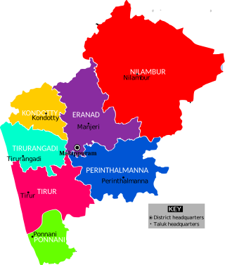
The Malappuram district has four types of administrative hierarchies:

Mangalam is a coastal village in Tirur Taluk, Malappuram district, Kerala, India. The village is located 9 kilometres (5.6 mi) south-west to the town of Tirur, 16 kilometres (9.9 mi) away from Ponnani, and 17 kilometres (11 mi) south to Tanur. Kootayi, known for its picturesque beach, is an important town in the jurisdiction of Mangalam Grama Panchayat.
Kethureddipatti is a Village Panchayat in Dharmapuri district of Tamil Nadu, India. It is located at 30 km (19 mi) from Dharmapuri town. It comes under Pappireddipatti taluk and Kadathur Block. It belongs to Pappireddipatti State Legislative Assembly Constituency and Dharmapuri Loksabha Constituency. It consists of nine panchayat wards. As per the 2011 Census, the total population of this village is 4,808.

