
Rock Rapids is a city in and the county seat of Lyon County, Iowa, United States. The population was 2,611 in the 2020 census, an increase from 2,573 in the 2000 census.
Merrill Township is a civil township of Newaygo County in the U.S. state of Michigan. The population was 590 at the 2000 census.

Saxonburg is a borough in Butler County, Pennsylvania, United States. It is part of the Pittsburgh metropolitan area in the western part of the state. It was founded in 1832 by F. Carl Roebling and his younger brother John as a German farming colony. The population of Saxonburg was 1,525 as of the 2010 census.

Rock Island is a city in Douglas County, Washington, United States. It is part of the Wenatchee–East Wenatchee Metropolitan Statistical Area. The population was 788 at the 2010 census.
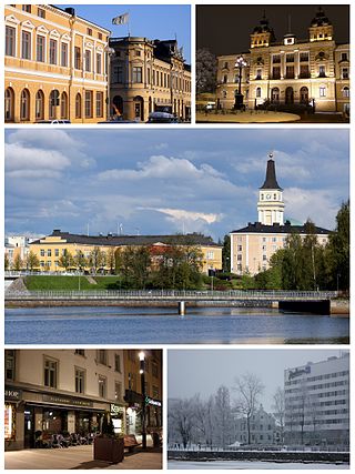
Oulu is a city, municipality and a seaside resort of about 210,000 inhabitants in the region of North Ostrobothnia, Finland. It is the most populous city in northern Finland and the fifth most populous in the country after: Helsinki, Espoo, Tampere and Vantaa, and the fourth largest urban area in the country after Helsinki, Tampere and Turku. Oulu's neighbouring municipalities are: Hailuoto, Ii, Kempele, Liminka, Lumijoki, Muhos, Pudasjärvi, Tyrnävä and Utajärvi.

Oulu Castle was a late defense castle in Oulu, Finland. It was built on an island in the delta of Oulu River in 1590. The castle was mostly made of wood and earth walls. There probably was an earlier medieval castle on the same site latest by 1375. The Russian Sophia Chronicle has recorded that men from Novgorod tried to conquer a new castle in the Oulu River delta in 1377 but were unsuccessful.
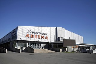
Oulun jäähalli, previously known as Raksilan jäähalli and called Oulun Energia Areena since 2006 for sponsorship reasons, is an ice sport arena in the Raksila Sports Centre, located in the Raksila district of Oulu, Finland. It is operated by the City of Oulu. The arena is best known as an ice hockey venue and the home of Liiga team Oulun Kärpät.
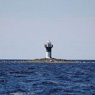
Rivinletto Light is a sector light tower located on Kaasamatala, a small island at the mouth of river Kiiminkijoki in Haukipudas, Oulu, Finland. The tower is concrete, with its top half painted black and bottom half painted white. The steel lantern room is painted white. The tower is located on the south side of the main channel of Kiiminkijoki river.
Mission Ridge, also known as Mission Mountain, is a ridge in the Bridge River-Lillooet Country of the South-Central Interior of British Columbia, Canada, extending westward from the town of Lillooet along the north side of Seton Lake to Mission Pass, which is immediately above and to the north of the lakeside community of Shalalth. The road over the pass is also known as Mission Mountain, which is short for "Mission Mountain Road". Mission Creek lies on the north side of the pass, and is a tributary of the Bridge River, the lower reaches of which lie on the north side of the ridge, and which was the only road access into the upper Bridge River Country before the construction of a road through the Bridge River Canyon in the mid-1950s opened that region up to road access from the lower Bridge River valley and the town of Lillooet via the community of Moha. Most, or virtually all, of the ridge, is Indian Reserves, notably Slosh 1, under the administration of the Seton Lake Indian Band, and Bridge River 1, which is under the administration of the Bridge River Indian Band. Parts of the ridge's eastern end are in reserves controlled by the Lillooet Indian Band, including its final spires above Lillooet, which were dubbed St. Mary's Mount by the Reverend Lundin Brown in the 1860s, though that name never stuck and is ungazetted.

Kiiminkijoki is a river of Finland in the region of Northern Ostrobothnia. It flows for 170 kilometres (110 mi) into the Gulf of Bothnia.

Myllytulli is a district of the city centre area of Oulu, Finland.

Koskikeskus is a neighbourhood in the Tuira area in the city of Oulu, Finland. The neighbourhood is located in the estuary of the river Oulujoki. The Tuira Bridges in Koskikeskus connect the city centre and Tuira neighbourhoods. The first bridges through the delta were built in late 1860s.
Pokkinen is a district of the city centre area of Oulu, Finland. Together with districts of Vaara and Vanhatulli, Pokkinen forms the central business district of Oulu. It is bounded by the estuary of the Oulujoki river to the west, the Koskikeskus and Myllytulli districts to the north, the Vaara district to the east and the Vanhatulli district to the south.

Vanhatulli is a district of the city centre area of Oulu, Finland. Together with the districts of Pokkinen and Vaara, Vanhatulli forms the central business district of Oulu. It is bounded by the estuary of the Oulujoki river to the west, the Pokkinen and Vaara districts to the north, the Leveri and Hollihaka districts to the south and the railway to the east.
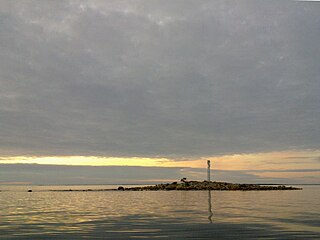
Lönkytin is an island in the Finnish sector of the Bay of Bothnia, off shore from the town of Haukipudas.

Haukipudas is a district of Oulu, Finland. Together with Jokikylä and Martinniemi districts, it forms the Haukipudas area. Haukipudas is located in the river delta of the Kiiminkijoki river. It is bounded by the Bothnian Bay in the west, National road 4 in the east, Martinniemi district in the north and Kello district in the south. The district was established in 2013 when the Haukipudas municipality together with Kiiminki, Oulunsalo and Yli-Ii municipalities were merged with the city of Oulu.

Kiiminki is a district of Oulu, Finland. Together with Alakylä, Hannus and Huttukylä districts, it forms the Kiiminki area. The center of the district is located where the National road 20 crosses the Kiiminkijoki river. The district was established in 2013 when the Kiiminki municipality together with Haukipudas, Oulunsalo and Yli-Ii municipalities were merged with the city of Oulu.

Karjasilta is a district in the Höyhtyä area in the city of Oulu, Finland. The district close to the city centre is bordered by the Raksila district to the north, Finnish national road 4 to the east, the Vanhatulli and Limingantulli districts to the west and the Nokela and Höyhtyä districts to the south.

Oulujoki is a former municipality of Finland. The municipality had a population of 5,230 (1963) and covered a land area of 606.1 square kilometres (234.0 sq mi). Its neighbouring municipalities were Kempele, Kiiminki, Muhos, Oulu, Tyrnävä, Utajärvi and Ylikiiminki. The municipality was named after the river Oulujoki.

Martinniemi is a district of Oulu, Finland. Together with Haukipudas and Jokikylä districts, it forms the Haukipudas area. Martinniemi is located in north of the river delta of the Kiiminkijoki river. It is bounded by the Bothnian Bay in the west, the Jokikylä district in the east, the Ii municipality in the north and the Kiiminkijoki river and the Haukipudas district in the south. The district was established in 2013 when the Haukipudas municipality together with Kiiminki, Oulunsalo and Yli-Ii municipalities were merged with the city of Oulu.

