
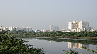
Coimbatore, sometimes shortened as Kovai, is one of the major metropolitan cities in the Indian state of Tamil Nadu. It is located on the banks of the Noyyal River and surrounded by the Western Ghats. Coimbatore is the second largest city in Tamil Nadu after Chennai in terms of population and the 16th largest urban agglomeration in India as per the census 2011. It is the administrative capital of Coimbatore District and is administered by the Coimbatore Municipal Corporation which was established in 1981.

Sathyamangalam is a town and municipality in Erode district in the Indian state of Tamil Nadu. It lies on the banks of the Bhavani river, a tributary of the Cauvery in the foothills of the Western Ghats and is the headquarters of Sathyamangalam taluk. It is about 65 km from Erode, 58 km from Tiruppur and 65 km from Coimbatore. As of 2011, the town had a population of 37,816.

Tirunelveli, also known as Nellai and historically as Tinnevelly, is a major city in the Indian state of Tamil Nadu. It is the administrative headquarters of the Tirunelveli District. It is the fourth-largest municipal corporation in the state after Chennai, Coimbatore, and Madurai. Tirunelveli is located 624 km (388 mi) southwest of the state capital Chennai, 58 km (36 mi) away from Thoothukudi, and 73 km (45 mi) from Kanyakumari. The downtown is located on the west bank of the Thamirabarani River; its twin Palayamkottai is on the east bank. Tirunelveli and its neighbourhood, Palayamkottai, have been called the Oxford of South India for their colleges. It has several important government offices.

Ariyalur district is an administrative district, one of the 38 districts in the state of Tamil Nadu in India. The district headquarters is located at Ariyalur. The district encompasses an area of 1,949.31 km2.

Madurai district is one of the 38 districts of the state of Tamil Nadu in southeastern India. The city of Madurai serves as the district headquarters. It houses the famous Sri Meenakshi Sundareshwarar temple and is situated on the banks of the river Vaigai. Thiruparankundram is one of the major tourist place in the district. As of 2011, the district had a population of 3,038,252 with a sex-ratio of 990 females for every 1,000 males. Aside from the city of Madurai, the larger towns are Melur, Vadipatti, Thirumangalam, Thirupparankundram, Peraiyur, and Usilampatti. It is an important hub for various film shootings. Alanganallur is a popular spot in the district for Jallikattu, as are Palamedu and Avaniyapuram.

Nagapattinam district is one of the 38 districts of Tamil Nadu state in southern India. Nagapattinam district was carved out by bifurcating the erstwhile composite Thanjavur district on 19 October 1991. The town of Nagapattinam is the district headquarters.
Guduvancheri is a suburb located to the south of Chennai city, Tamil Nadu, India. It has a railway station on the Chennai Beach–Chengalpattu section of the Chennai Suburban Railway Network and is a municipality in Chengalpattu district, Tamil Nadu, India. It is also part of the Vandalur taluk and lies in the southern part of Chennai metropolitan area. It has a lake known as the Guduvancheri lake and Nandivaram lake. It serves as the connecting hub between Chennai and Chengalpattu. It also lies on the major highway connecting Chennai with Kanyakumari, the southernmost point of the state and the country.

Injambakkam is a locality in the south of Chennai in the Indian state of Tamil Nadu. Being a part of the Walajabad block of the district, its panchayat is part of Walajabad panchayat union. Injambakkam is located along the ECR.

Kallakurichi is a Municipality in the Indian state of Tamil Nadu and the administrative headquarters of Kallakurichi district in Tamil Nadu. As of 2019, the town had a population of 73528.
Sholinganallur, also spelled Solinganalloor or Sozhinganalloor, is a southern suburb of Chennai, India.
A nagar panchayat or town panchayat or Notified Area Council (NAC) in India is a settlement in transition from rural to urban and therefore a form of an urban political unit comparable to a municipality. An urban centre with more than 12,000 and less than 40,000 inhabitants is classified as a nagar panchayat. The population requirement for a Town Panchayat can vary from state to state.
Papanasam taluk is a taluk of Thanjavur district of the Indian state of Tamil Nadu. The headquarters of the taluk is the town of Papanasam.
Tiruttani Assembly Constituency is a state assembly constituency in Tiruvallur district in Tamil Nadu. Its State Assembly constituency number is 3. It consists of Pallipattu taluk and a portion of Tiruttani taluk. It falls under the Arakkonam Lok Sabha constituency. It is one of the 234 state legislative assembly constituencies in Tamil Nadu, India. Elections and winners in the constituency are listed below.
Sangagiri taluk is a taluk of Salem district of the Indian state of Tamil Nadu. The headquarters of the taluk is the town of Sangagiri. Sangagiri Fort is the one of the tourist spot on this taluk
Madhavaram taluk is a taluk of Chennai district in the Indian state of Tamil Nadu. The centre of the taluk is the neighbourhood of Madhavaram. The headquarters of the taluk is Tondiarpet division. And the taluk has been bifurcated from Ambattur taluk and on 2018 it has been annexed to Chennai district from tiruvallur by expanding Chennai city. And the taluk Has regions of Kathirvedu, Lakshmipuram, Madhavaram, Madhavaram Milk Colony, Mathur, Ponniammanmedu, Puthagaram, Puzhal, Surapet, Redhills, and the RTO of the taluk is TN 05.
Alathur is a village in Tiruchirappalli taluk of Tiruchirappalli district, Tamil Nadu. It was merged with the Tiruchirappalli Corporation in 2011.
Ellakudy is a village in Tiruchirappalli taluk of Tiruchirappalli district, Tamil Nadu, India. It was merged with the Tiruchirappalli Corporation in 2011.
Kilakalkandarkottai is a village in Tiruchirappalli taluk of Tiruchirappalli district in Tamil Nadu, India. It was merged with the Tiruchirappalli Corporation in 2011.
Natarajapuram is a village in Tiruchirappalli taluk of Tiruchirappalli district in Tamil Nadu, India.
Vadamadurai is a panchayat village in Thiruvallur district in the Indian state of Tamil Nadu.