Related Research Articles

Svalbard, also known as Spitsbergen or Spitzbergen, is a Norwegian archipelago in the Arctic Ocean. North of mainland Europe, it lies about midway between the northern coast of Norway and the North Pole. The islands of the group range from 74° to 81° north latitude, and from 10° to 35° east longitude. The largest island is Spitsbergen, followed in size by Nordaustlandet and Edgeøya. The largest settlement is Longyearbyen on the west coast of Spitsbergen.

Bear Island is the southernmost island of the Norwegian Svalbard archipelago. The island is located at the limits of the Norwegian and Barents seas, approximately halfway between Spitsbergen and the North Cape. Bear Island was discovered by Dutch explorers Willem Barentsz and Jacob van Heemskerck on 10 June 1596. It was named after a polar bear that was seen swimming nearby. The island was considered terra nullius until the Spitsbergen Treaty of 1920 placed it under Norwegian sovereignty.

Hopen is an island in the southeastern part of the Svalbard archipelago (Norway). Hopen was discovered in 1596 by Jan Cornelisz Rijp during the third expedition by Willem Barentsz, trying to find the Northeast Passage. Later, in 1613, its name was given by Thomas Marmaduke of Hull, who named it after his former command, the Hopewell.

Barentsøya, anglicized as Barents Island, is an island in the Svalbard archipelago of Norway, lying between Edgeøya and Spitsbergen. Barents Island has no permanent human inhabitants. Named for the Dutch explorer Willem Barents, it is a part of Søraust-Svalbard Nature Reserve.

Danes Island is an island in Norway's Svalbard archipelago in the Arctic Ocean with an area of 40.6 km2 (15.7 sq mi). It lies just off the northwest coast of Spitsbergen, the largest island in the archipelago, near to Magdalenefjorden. Just to the north lies Amsterdam Island. Most of Svalbard's islands, including Danes Island, are uninhabited; only Spitsbergen, Bjørnøya and Hopen have settlements.

The following outline is provided as an overview of and topical guide to Svalbard:
Svalbard is an Arctic, wilderness archipelago comprising the northernmost part of Norway. It is mostly uninhabited, with only about 3,000 people, yet covers an area of 61,020 square kilometres (23,560 sq mi).

Werner Werenskiold was a Norwegian geologist and geographer. He was a son of Erik Werenskiold and visual artist Sophie Marie Stoltenberg Thomesen (1849–1926), and the brother of Dagfin Werenskiold.

Sørkapp Land is the land area south of Hornsund, at the southern part of Spitsbergen, Svalbard. Two glaciers, Hornbreen and Hambergbreen, divide Sørkapp Land from Torell Land.
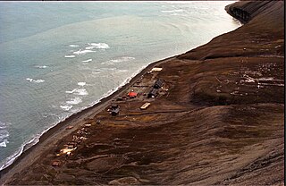
Hopen Radio is a coast radio station and the only settlement on the island of Hopen in Svalbard, Norway. It is located between Kollerfjellet and Werenskioldfjellet.
Iversenfjellet is the highest mountain of Hopen in the Svalbard archipelago. It has a height of 371 m.a.s.l. and is located at the southern portion of Hopen. The mountain is named after fisheries consultant Thor Iversen.
Thor Iversen (1873–1953) was a Norwegian advisor to the Board of Fisheries. From 1923 he was in charge of the inspection of hunting and fishing in the Arctic Ocean. Among his books are Drivis og selfangst from 1927, and Ishavsøya Hopen from 1941.
Kapp Thor is the southernmost point of Hopen in the Svalbard archipelago. It is named after fisheries advisor Thor Iversen.
Beisaren is the northernmost point of the island of Hopen in the Svalbard archipelago. It is named after hunter Berner Jørgensen, whose nickname was "Beisaren".
Samarinvågen is a bay in Sørkapp Land at Spitsbergen, Svalbard. It is a southern bay of the fjord Hornsund, located between Meranfjellet and Traunkammen. The bay is named after Samarin, member of Arctic expeditions between 1899 and 1902. The glacier Samarinbreen debouches into the bay.
Vasil'evbreen is a glacier in Sørkapp Land at Spitsbergen, Svalbard. It has an extension of about twenty kilometers, with several tributary glaciers. It is named after Russian astronomer Alexandr Semenovich Vasil'ev. The glacier has a wide front facing towards the eastern shore of Spitsbergen, including the bay of Isbukta. The southern part of Vasil'evbreen is called Randbreen, located north of Istoppane and Dumskolten, and south of Søre Randberget.
Comfortlessbreen is a glacier in Oscar II Land at Spitsbergen, Svalbard. It has a length of about fourteen kilometers, and a maximum width of three kilometers. The glacier debouches into Engelskbukta, after a merge with Uvêrsbreen. Comfortlessbreen is separated from Uvêrsbreen by the mountain range of Trondheimfjella.
Hedgehogfjellet is a mountain in Sørkapp Land at Spitsbergen, Svalbard. It has a height of 615 m.a.s.l. The mountain is situated south of Tvillingtoppen, between the sea and the glacier of Hedgehogfonna.
Werenskioldfjellet is a mountain at Hopen, Svalbard. The mountain is named after Norwegian geologist and Arctic explorer Werner Werenskiold.
References
- ↑ "Kollerfjellet (Svalbard)". Norwegian Polar Institute . Retrieved 12 February 2015.
- ↑ "Hopen radio (Svalbard)". Norwegian Polar Institute . Retrieved 12 February 2015.
76°32′12″N25°03′15″E / 76.5366°N 25.0542°E
| | This Svalbard mountain, mountain range, or peak related article is a stub. You can help Wikipedia by expanding it. |