Related Research Articles

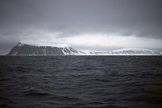
Hopen is an island in the southeastern part of the Svalbard archipelago (Norway). Hopen was discovered in 1596 by Jan Cornelisz Rijp during the third expedition by Willem Barentsz, trying to find the Northeast Passage. Later, in 1613, its name was given by Thomas Marmaduke of Hull, who named it after his former command, the Hopewell.
Barentsøya, sometimes anglicized as Barents Island, is an island in the Svalbard archipelago of Norway, lying between Edgeøya and Spitsbergen. Barents Island has no permanent human inhabitants. Named for the Dutch explorer Willem Barents, it is a part of Søraust-Svalbard Nature Reserve.
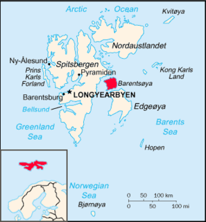
Svalbard is an Arctic, wilderness series of islands comprising the northernmost part of the Norwegian territories. It is mostly uninhabited, with only about 3,000 people, yet covers an area of 61,020 square kilometres (23,560 sq mi).

Werner Werenskiold was a Norwegian geologist and geographer. He was a son of Erik Werenskiold and visual artist Sophie Marie Stoltenberg Thomesen (1849–1926), and the brother of Dagfin Werenskiold.
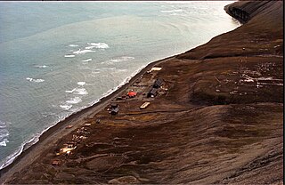
Hopen Radio is a coast radio station and the only settlement on the island of Hopen in Svalbard, Norway. It is located between Kollerfjellet and Werenskioldfjellet.
Iversenfjellet is the highest mountain of Hopen in the Svalbard archipelago. It has a height of 371 m.a.s.l. and is located at the southern portion of Hopen. The mountain is named after fisheries consultant Thor Iversen.
Thor Iversen (1873–1953) was a Norwegian advisor to the Board of Fisheries. From 1923 he was in charge of the inspection of hunting and fishing in the Arctic Ocean. Among his books are Drivis og selfangst from 1927, and Ishavsøya Hopen from 1941.
Beisaren is the northernmost point of the island of Hopen in the Svalbard archipelago. It is named after hunter Berner Jørgensen, whose nickname was "Beisaren".
Dumskolten is a mountain in Sørkapp Land at Spitsbergen, Svalbard. It has a height of 596 m.a.s.l., and is located south of the glacier Vasil'evbreen, north of the coastal plain Skoltsletta. The glacier Dumskoltbreen is located west of the mountain, between Dumskolten and Istoppane.
Breinesflya is a coastal plain at the western coast of Sørkapp Land at Spitsbergen, Svalbard. It has a length of about twelve kilometers, extending from the river of Vinda to Raksodden. Slaklielva from Gråkallbreen through Slaklidalen flows across Breinesflya, as does Lidelva coming from Liddalen. At the northeastern side of the plain are the mountains Wiederfjellet and Lidfjellet.
Comfortlessbreen is a glacier in Oscar II Land at Spitsbergen, Svalbard. It has a length of about fourteen kilometers, and a maximum width of three kilometers. The glacier debouches into Engelskbukta, after a merge with Uvêrsbreen. Comfortlessbreen is separated from Uvêrsbreen by the mountain range of Trondheimfjella.
Svalisbreen is a glacier in Sørkapp Land at Spitsbergen, Svalbard. It has a length of about 12.5 kilometers, extending from the mountain pass of Svanhildpasset to Hornbreen, towards the bay of Brepollen, the inner part of Hornsund.
Hedgehogfjellet is a mountain in Sørkapp Land at Spitsbergen, Svalbard. It has a height of 615 m.a.s.l. The mountain is situated south of Tvillingtoppen, between the sea and the glacier of Hedgehogfonna.
Kvitskarvbreen is a glacier in Nathorst Land at Spitsbergen, Svalbard. It has a length of about 8.5 kilometers, and extend northwestwards from the mountain of Kvitskarvet to the valley of Bromelldalen. The glaicers of Lundbreen, Juvbreen and Zimmerbreen are all tributaries to Kvitskarvbreen.
Sysselmannbreen is a glacier in Nathorst Land at Spitsbergen, Svalbard. It has a length of about eleven kilometers, and extends southwestwards from the mountain of Kvitskarvet to the valley of Steenstrupdalen. The mountain of Marlowfjellet separates Sysselmannbreen from Steenstrupbreen.
Kollerfjellet is a mountain at Hopen, Svalbard. It has a height of 304 m.a.s.l., and its first known ascent was made in 1924 during topographic works.
Steenstrupdalen is a valley in Nathorst Land at Spitsbergen, Svalbard. It is named after Danish geologist Knud Johannes Vogelius Steenstrup. The valley is surrounded by the mountains of Otto Pettersonfjellet, Marlowfjellet and Brogniartfjella. The glaciers of Sysselmannbreen and Steenstrupbreen end up into the valley.
Marlowfjellet is a mountain in Nathorst Land at Spitsbergen, Svalbard. It has three peaks of 1,052, 1,016 and 1,022, m.a.s.l., respectively, and extends over a length of about six kilometers. The mountain is surrounded by the glaciers of Sysselmannbreen and Steenstrupbreen. It is named after Norwegian mining engineer and military officer Wolmer Tycho Marlow.
Davisdalen is a valley in Nathorst Land at Spitsbergen, Svalbard. It is named after American geomorphologist William Morris Davis. The valley has a length of about 5.5 kilometers, extending from the mountain ridge of Mjellegga southwards down to Davisodden, at the northern side of Van Keulenfjorden. A tributary valley to Davisdalen is Wittrockdalen.

Arrheniusfjellet is a mountain in Torell Land at Spitsbergen, Svalbard. It is named after Swedish physicist Svante Arrhenius. The mountain has a height of 883 m.a.s.l. and is located at the head of Van Keulenfjorden. The glacier of Vindbreen separates Arrheniusfjellet from Vindfjellet at the southern side. The large glacier of Liestølbreen is situated between Arrheniusfjellet and Wijkberget, and Nathorstbreen is located southwest of the mountain.
References
- ↑ "Werenskioldfjellet (Svalbard)". Norwegian Polar Institute . Retrieved 12 February 2015.
- ↑ "Hopen radio (Svalbard)". Norwegian Polar Institute . Retrieved 12 February 2015.
- ↑ Hansen, Ståle; Kjølleberg, Even; Lior, Håvard; Jacobsen, Alf R.; Toverud, Lars (8 February 2015). "Iskaldt kappløp" (in Norwegian). NRK . Retrieved 12 February 2015.
Coordinates: 76°29′56″N24°57′43″E / 76.499°N 24.962°E
| This Svalbard mountain, mountain range, or peak related article is a stub. You can help Wikipedia by expanding it. |