
Emery County is a county in east-central Utah, United States. As of the 2010 United States Census, the population was 10,976. Its county seat is Castle Dale, and the largest city is Huntington.

Juab County is a county in western Utah, United States. As of the 2010 United States Census, the population was 10,246. Its county seat and largest city is Nephi.
Rich County is a county in the U.S. state of Utah. As of the 2010 United States Census, the population was 2,264, making it the third-least populous county in Utah. Its county seat is Randolph, and the largest town is Garden City. The county was created in 1864. It was named for an early LDS apostle, Charles C. Rich.

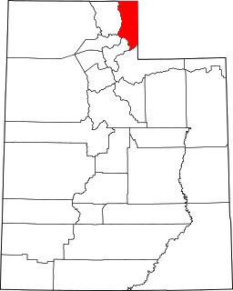
Summit County is a county in the U.S. state of Utah, occupying a rugged and mountainous area. As of the 2010 United States Census, the population was 36,324. Its county seat is Coalville, and the largest city is Park City.

Tooele County is a county in the U.S. state of Utah. As of the 2010 United States Census, the population was 58,218. Its county seat and largest city is Tooele. The county was created in 1850 and organized the following year.

Uintah County is a county in the U.S. state of Utah. As of the 2010 United States Census the population was 32,588. Its county seat and largest city is Vernal. The county was named for the portion of the Ute Indian tribe that lived in the basin.
Scouting in Nevada has a long history, from the 1910s to the present day, serving thousands of youth in programs that suit the environment in which they live.

Delta is the largest city in Millard County, Utah, United States. It is located at the northeastern area of Millard County along the Sevier River and is surrounded by farm land. The population was 3,436 at the 2010 census.

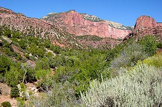
The geology of the Zion and Kolob canyons area includes nine known exposed formations, all visible in Zion National Park in the U.S. state of Utah. Together, these formations represent about 150 million years of mostly Mesozoic-aged sedimentation in that part of North America. Part of a super-sequence of rock units called the Grand Staircase, the formations exposed in the Zion and Kolob area were deposited in several different environments that range from the warm shallow seas of the Kaibab and Moenkopi formations, streams and lakes of the Chinle, Moenave, and Kayenta formations to the large deserts of the Navajo and Temple Cap formations and dry near shore environments of the Carmel Formation.
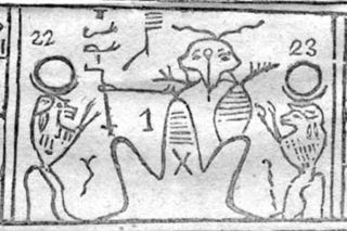
Kolob is a star or planet described in the Book of Abraham, a sacred text of the Latter Day Saint movement. Several Latter Day Saint denominations hold the Book of Abraham to have been translated from an Egyptian papyrus scroll by Joseph Smith, the founder of the movement. According to this work, Kolob is the heavenly body nearest to the throne of God. While the Book of Abraham calls Kolob a "star", it also calls planets "stars", and therefore some Latter Day Saint commentators consider Kolob a planet. The body also appears in Latter Day Saint culture, including a reference to Kolob in an LDS hymn.
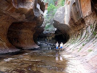
The Subway is a small, uniquely-shaped slot canyon within the Zion Wilderness in Zion National Park in northeastern Washington County, Utah, United States. The National Park Service limits access to the canyon via a permit system.
Horse Ranch Mountain is an 8,733-foot (2,662 m) mountain in the Kolob Canyons section of Zion National Park in northeastern Washington County, Utah, United States, that is the highest summit within the national park. It rises above Camp Creek to the north and Taylor Creek to the south. Its neighbors include Tucupit Point, 1 mi (1.6 km) to the south, and Timber Top Mountain is situated 3.9 mi (6.3 km) to the south-southwest.

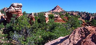
Zion National Park is an American national park located in southwestern Utah near the town of Springdale. A prominent feature of the 229-square-mile (590 km2) park is Zion Canyon, which is 15 miles (24 km) long and up to 2,640 ft (800 m) deep. The canyon walls are reddish and tan-colored Navajo Sandstone eroded by the North Fork of the Virgin River. The lowest point in the park is 3,666 ft (1,117 m) at Coalpits Wash and the highest peak is 8,726 ft (2,660 m) at Horse Ranch Mountain. Located at the junction of the Colorado Plateau, Great Basin, and Mojave Desert regions, the park has a unique geography and a variety of life zones that allow for unusual plant and animal diversity. Numerous plant species as well as 289 species of birds, 75 mammals, and 32 reptiles inhabit the park's four life zones: desert, riparian, woodland, and coniferous forest. Zion National Park includes mountains, canyons, buttes, mesas, monoliths, rivers, slot canyons, and natural arches.
LaVerkin Creek Wilderness is a 445-acre (1.8 km2) wilderness area in the US state of Utah. It was designated March 30, 2009, as part of the Omnibus Public Land Management Act of 2009. Located adjacent to the Kolob Canyons region of Zion National Park, it encompasses and protects the upper headwaters of LaVerkin Creek, a tributary of the Wild & Scenic Virgin River. Another portion of the creek is protected by the Black Ridge Canyon Wilderness. LaVerkin Creek Wilderness is bordered by the Zion Wilderness to the south.
Taylor Creek Wilderness is a 32-acre (0.1 km2) wilderness area in the US state of Utah. It was designated March 30, 2009, as part of the Omnibus Public Land Management Act of 2009. Located adjacent to the Kolob Canyons region of Zion National Park, it encompasses and protects the upper headwaters of Taylor Creek, a tributary of the Wild & Scenic Virgin River. Taylor Creek Wilderness is bordered by the Zion Wilderness to the southwest.
Beartrap Canyon Wilderness is a 40-acre (0.2 km2) wilderness area in the US state of Utah. It was designated March 30, 2009, as part of the Omnibus Public Land Management Act of 2009. Located adjacent to the Kolob Canyons region of Zion National Park, it encompasses and protects part of Beartrap Canyon Creek, a tributary of the Wild & Scenic Virgin River. Beartrap Canyon Wilderness is bordered by the Zion Wilderness to the east.
Red Butte Wilderness is a 1,537-acre (6.2 km2) wilderness area in the US state of Utah. It was designated March 30, 2009, as part of the Omnibus Public Land Management Act of 2009. Located adjacent to Kolob Canyons section of Zion National Park, it encompasses and protects much of the 1,800-foot (550 m) Red Butte. Red Butte Wilderness is bordered by the Zion Wilderness to the north.
Kolob Creek Dam is a dam in Washington County, Utah.
The Washington County Water Conservancy District (WCWCD) is a water district covering Washington County, Utah. It was formed in 1962 by local petition. The district provides wholesale water to the cities of St. George, Washington, Hurricane, Santa Clara, Ivins, Toquerville, La Verkin, Leeds, and the town of Virgin. The cities are required to engage in water conservation and recycling, and the district is required to develop water sources to meet the needs determined by city governments. The district also supplies drinking water to retail customers in the unincorporated areas of Sky Ranch, Cliffdweller Ranch, Casa de Oro, and (seasonally) Kolob.


