Gmina Adamówka is a rural gmina in Przeworsk County, Subcarpathian Voivodeship, in south-eastern Poland. Its seat is the village of Adamówka, which lies approximately 26 kilometres (16 mi) north-east of Przeworsk and 56 km (35 mi) north-east of the regional capital Rzeszów.
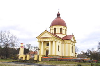
The Battle of Kuryłówka, fought between the Polish anti-communist resistance organization, National Military Alliance (NZW) and the Soviet Union's NKVD units, took place on May 7, 1945, in the village of Kuryłówka, southeastern Poland. The battle ended in a victory for the underground Polish forces.

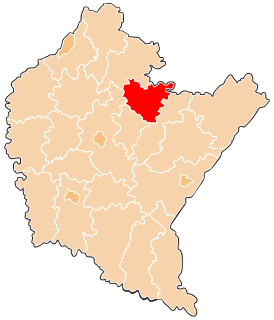
Kuryłówka is a village in Leżajsk County, Subcarpathian Voivodeship, in south-eastern Poland. It is the seat of the gmina called Gmina Kuryłówka. It lies on the navigable San River, approximately 5 kilometres (3 mi) north-east of Leżajsk and 44 km (27 mi) north-east of the regional capital Rzeszów. The village is located in the historical region Galicia.

Gmina Krzeszów is a rural gmina in Nisko County, Subcarpathian Voivodeship, in south-eastern Poland. Its seat is the village of Krzeszów, which lies approximately 21 kilometres (13 mi) south-east of Nisko and 48 km (30 mi) north-east of the regional capital Rzeszów.

Brzyska Wola is a village in the administrative district of Gmina Kuryłówka, within Leżajsk County, Subcarpathian Voivodeship, in south-eastern Poland. It lies approximately 9 kilometres (6 mi) north-east of Kuryłówka, 13 km (8 mi) north-east of Leżajsk, and 53 km (33 mi) north-east of the regional capital Rzeszów.
Dąbrowica is a village in the administrative district of Gmina Kuryłówka, within Leżajsk County, Subcarpathian Voivodeship, in south-eastern Poland. It lies approximately 7 kilometres (4 mi) east of Kuryłówka, 10 km (6 mi) east of Leżajsk, and 49 km (30 mi) north-east of the regional capital Rzeszów.
Jastrzębiec is a village in the administrative district of Gmina Kuryłówka, within Leżajsk County, Subcarpathian Voivodeship, in south-eastern Poland. It lies approximately 15 kilometres (9 mi) east of Kuryłówka, 19 km (12 mi) north-east of Leżajsk, and 58 km (36 mi) north-east of the regional capital Rzeszów.

Kulno is a village in the administrative district of Gmina Kuryłówka, within Leżajsk County, Subcarpathian Voivodeship, in south-eastern Poland. It lies approximately 5 kilometres (3 mi) north of Kuryłówka, 9 km (6 mi) north-east of Leżajsk, and 48 km (30 mi) north-east of the regional capital Rzeszów.
Ożanna is a village in the administrative district of Gmina Kuryłówka, within Leżajsk County, Subcarpathian Voivodeship, in south-eastern Poland. It lies approximately 5 kilometres (3 mi) east of Kuryłówka, 7 km (4 mi) east of Leżajsk, and 47 km (29 mi) north-east of the regional capital Rzeszów.
Słoboda is a village in the administrative district of Gmina Kuryłówka, within Leżajsk County, Subcarpathian Voivodeship, in south-eastern Poland. It lies approximately 11 kilometres (7 mi) east of Kuryłówka, 13 km (8 mi) east of Leżajsk, and 53 km (33 mi) north-east of the regional capital Rzeszów.
Tarnawiec is a village in the administrative district of Gmina Kuryłówka, within Leżajsk County, Subcarpathian Voivodeship, in south-eastern Poland. It lies approximately 2 kilometres (1 mi) south-east of Kuryłówka, 4 km (2 mi) north-east of Leżajsk, and 44 km (27 mi) north-east of the regional capital Rzeszów.
Wólka Łamana is a village in the administrative district of Gmina Kuryłówka, within Leżajsk County, Subcarpathian Voivodeship, in south-eastern Poland. It lies approximately 8 kilometres (5 mi) north-east of Kuryłówka, 12 km (7 mi) north-east of Leżajsk, and 52 km (32 mi) north-east of the regional capital Rzeszów.
Dębno is a village in the administrative district of Gmina Leżajsk, within Leżajsk County, Subcarpathian Voivodeship, in south-eastern Poland. It lies approximately 10 kilometres (6 mi) south-east of Leżajsk and 41 km (25 mi) north-east of the regional capital Rzeszów.
Gwizdów is a village in the administrative district of Gmina Leżajsk, within Leżajsk County, Subcarpathian Voivodeship, in south-eastern Poland. It lies approximately 11 kilometres (7 mi) south-west of Leżajsk and 30 km (19 mi) north-east of the regional capital Rzeszów.
Hucisko is a village in the administrative district of Gmina Leżajsk, within Leżajsk County, Subcarpathian Voivodeship, in south-eastern Poland. It lies approximately 11 kilometres (7 mi) west of Leżajsk and 33 km (21 mi) north-east of the regional capital Rzeszów.
Maleniska is a village in the administrative district of Gmina Leżajsk, within Leżajsk County, Subcarpathian Voivodeship, in south-eastern Poland. It lies approximately 8 kilometres (5 mi) west of Leżajsk and 35 km (22 mi) north-east of the regional capital Rzeszów.

Jelna is a village in the administrative district of Gmina Nowa Sarzyna, within Leżajsk County, Subcarpathian Voivodeship, in south-eastern Poland. It lies approximately 4 kilometres (2 mi) south-east of Nowa Sarzyna, 7 km (4 mi) north-west of Leżajsk, and 39 km (24 mi) north-east of the regional capital Rzeszów.
Łukowa is a village in the administrative district of Gmina Nowa Sarzyna, within Leżajsk County, Subcarpathian Voivodeship, in south-eastern Poland. It lies approximately 4 kilometres (2 mi) east of Nowa Sarzyna, 8 km (5 mi) north-west of Leżajsk, and 42 km (26 mi) north-east of the regional capital Rzeszów.
Ruda Łańcucka is a village in the administrative district of Gmina Nowa Sarzyna, within Leżajsk County, Subcarpathian Voivodeship, in south-eastern Poland. It lies approximately 3 kilometres (2 mi) east of Nowa Sarzyna, 9 km (6 mi) north-west of Leżajsk, and 41 km (25 mi) north-east of the regional capital Rzeszów.