Related Research Articles

Guinea-Bissau, officially the Republic of Guinea-Bissau, is a country in West Africa that covers 36,125 square kilometres (13,948 sq mi) with an estimated population of 2,026,778. It borders Senegal to its north and Guinea to its southeast.

Gabú region is the easternmost region in Guinea-Bissau. Its capital is Gabú. The region borders Senegal to the north, Guinea to the east and south and the Guinea-Bissau regions of Tombali and Bafatá to the west. It covers an area of 9,150 km2, making it the largest of Guinea-Bissau's administrative regions. It is an inland region covered with savannah or light savannah woodland and receives an annual rainfall of more than 2,000 mm (79 in).
Oio is a region in Guinea-Bissau. Its capital is Farim. Other major cities and towns include Nhacra, Mansôa, Bissorã and Cumeré. The region borders Senegal to the north, the Guinea-Bissau regions of Bafatá, Bissau and Biombo to the east, the Rio Geba/Guinea-Bissau region of Quinara to the south and the Guinea-Bissau region of Cacheu to the west. There has not been any local administration since the civil war of 1998-99 and all the social services are done by organs of civil society and other government agencies. It is a coastal region covered with Mangrove swamps, rain forest and tangled forest and receives an annual rainfall of more than 1,000 mm (39 in), while the inland has savannah woodlands.

Bubaque is one of the Bijagós Islands in Guinea-Bissau, and is also the name of its main town. The island has a population of 6,427, while the town of Bubaque has a population of 4,299. The area of the island is 75 km2, it is 13.6 km long and 8 km wide.
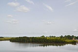
Orango is one of the Bijagós Islands, located 60 kilometres off the coast of mainland Guinea-Bissau. At 272.5 km2, it is the largest island in the archipelago. The island has a population of 1,250 ; the largest village is Eticoga. With the neighbouring islands Imbone, Canongo, Meneque and Orangozinho, it forms the Orango National Park. It belongs to the Uno Sector.
João Vieira is an island in the Bijagós Archipelago of Guinea-Bissau. Its population is 6. It is part of the João Vieira and Poilão Marine National Park. It lies 11 nmi (20 km) north-northeast of the island Poilão. Other nearby islands are Meio and Cavalos. The islands are important nesting grounds for sea turtles.

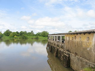
Farim is a town of northern Guinea-Bissau. It sits on the north bank of the Farim/Cacheu River, about 215 km up the river from Cacheu. Population 8,661.

Tombali is one of the eight regions of Guinea-Bissau. It is located in the extreme south of the country and its capital is Catió. There has not been any local administration since the civil war of 1998-99 and all social services are done by organs of civil society and other government agencies. It is a coastal region covered with mangrove swamps, rain forest and tangled forest and receives an annual rainfall of more than 2,000 millimetres or 79 inches.

Quinara is a region in central Guinea-Bissau and its capital is Fulacunda. There has not been any local administration since the civil war of 1998-99 and all the social services are done by organs of civil society and other government agencies. It is a coastal region covered with Mangrove swamps, rain forest and tangled forest and receives an annual rainfall of more than 1,000 mm (39 in).

Cacheu is a region in western Guinea-Bissau, on the border with Senegal. It has an area of 5,175 km2 and a population estimated in 2004 at 164,676. Its capital is Cacheu. There has not been any local administration since the civil war of 1998-99 and all the social services are done by organs of civil society and other government agencies. It is a coastal region covered with Mangrove swamps, rain forest and tangled forest and receives an annual rainfall of more than 1,000 mm (39 in)

Biombo is a region in western Guinea-Bissau, with an area of 840 km2 and its capital is Quinhámel. There has not been any local administration since the civil war of 1998-99, and all the social services are done by organs of civil society and other government agencies. It is a coastal region covered with Mangrove swamps, rain forest, tangled forest, and receives an annual rainfall of more than 1,000 mm (39 in).
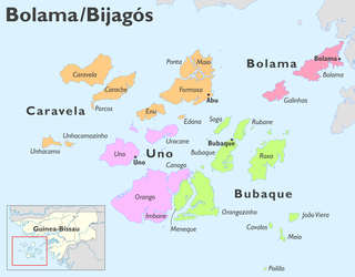
Bolama is an administrative region in Guinea-Bissau, consisting primarily of the Bijagós Archipelago of the country's southern coast, together with a small coastal strip centred on the coastal town of São João. It has an area of 2,624 km2. Its capital is Bolama, on the island of the same name. It is a coastal region covered with Mangrove swamps, rain forest and tangled forest and receives an annual rainfall of more than 1,000 mm (39 in).
Bafatá is a region in north-central Guinea-Bissau and its capital is Bafatá. It is an inland region covered with savannah or light savannah woodland and receives an annual rainfall of more than 2,000 mm (79 in).

There are 39 sectors of Guinea-Bissau which subdivide the regions. The sectors are further subdivided into smaller groups called sections ; which are further subdivided into populated places. Here are the following listed below, by region:
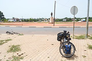
Safim is a city and sector in the Biombo Region of Guinea-Bissau. It has a population of 17,356 inhabitants as of the 2009 national census.

Caravela is the northernmost island of the Bissagos Islands of Guinea-Bissau, part of the Sector of Caravela, which also includes the islands Carache, Maio, Ponta and Formosa. The population of the sector is 4,263, the population of the island is 907. The area of the island is 128 km2, its length is 19.3 km and its width is 10 km. The island is heavily forested with mangroves. It has white, sandy beaches. Caravela has a small airfield. The island Carache lies to its southeast.
Formosa is an island in the Bissagos Islands, Guinea-Bissau, part of the sector of Caravela. Its area is 140 km2, its length is 19.9 km and its width is 10 km. It forms practically one island with Ponta and Maio, separated by creeks. The island has a population of 1,873 ; the largest village is Abú.

Roxa or Canhabaque is an island in the Bissagos Islands, Guinea-Bissau. It is part of the sector of Bubaque. Its area is 111 square kilometres (43 sq mi); it is 20 kilometres (12 mi) long and 11 kilometres (6.8 mi) wide. The island has a population of 2,478, divided over the villages Ambuduco, Ampucute, Ancanhozinho, Indenazinho, Ancaguine, Ancatipe, Angaura, Indena Grande, Ga-Cote, Inore, Ambena, Bine, Inhoda, Idjoue, Eboco, Meneque, Ancanam, Anghudjiga, Anghumba and Antchurupe. There is a lighthouse on the east side of the island, its focal height is 26 m (85 ft).
Komo or KOMO may refer to:

Tite is one of four Sectors of Quinara Region of Guinea-Bissau. It has an area of 699.5 km2.
References
- ↑ "População por região, sector e localidades por sexo censo 2009" (PDF) (in Portuguese). Archived from the original (PDF) on 31 March 2020. Retrieved 20 November 2017.
- ↑ Mendy, Peter Karibe; Lobban, Richard A. Jr. (2013). Historical Dictionary of the Republic of Guinea-Bissau (Fourth ed.). Scarecrow Press. ISBN 978-0-8108-5310-2.
11°11′N15°18′W / 11.183°N 15.300°W
| | This Guinea-Bissau location article is a stub. You can help Wikipedia by expanding it. |