Related Research Articles

Blackdown Tableland is a national park in the Central Highlands Region, Queensland, Australia.
Hann Tableland is a national park in Far North Queensland (Australia), 1,436 km northwest of Brisbane. It is located in the northern section of Paddys Green, a locality in the Tablelands Region local government area. It was first set aside as national park in 1989 and nearly doubled in size with an expansion in 2004.

The Wet Tropics of Queensland World Heritage Site consists of approximately 8,940 km2 of Australian wet tropical forests growing along the north-east Queensland portion of the Great Dividing Range. The Wet Tropics of Queensland meets all four of the criteria for natural heritage for selection as a World Heritage Site. World Heritage status was declared in 1988, and on 21 May 2007 the Wet Tropics were added to the Australian National Heritage List.

The Atherton Tableland is a fertile plateau, which is part of the Great Dividing Range in Queensland, Australia. It has very deep, rich basaltic soils and the main industry is agriculture. The principal river flowing across the plateau is the Barron River, which was dammed to form the irrigation reservoir named Lake Tinaroo. Unlike many other rural areas, the Tablelands is experiencing a significant growth in population.

Kuranda is a rural town and locality on the Atherton Tableland in the Shire of Mareeba, Queensland, Australia. It is 25 kilometres (16 mi) from Cairns, via the Kuranda Range road. It is surrounded by tropical rainforest and adjacent to the Wet Tropics of Queensland World Heritage listed Barron Gorge National Park. In the 2021 census, the locality of Kuranda had a population of 3,273 people.

Far North Queensland (FNQ) is the northernmost part of the Australian state of Queensland. Its largest city is Cairns and it is dominated geographically by Cape York Peninsula, which stretches north to the Torres Strait, and west to the Gulf Country. The waters of Torres Strait include the only international border in the area contiguous with the Australian mainland, between Australia and Papua New Guinea.

The Malanda Falls is a cascade waterfall on the North Johnstone River, located in the Tablelands Region in the Far North of Queensland, Australia.

The Blencoe Falls is a segmented waterfall on the Blencoe Creek, located in Kirrama, Tablelands Region, in Far North Queensland, Australia.
Koombooloomba is a rural locality in the Tablelands Region, Queensland, Australia. In the 2021 census, the locality of Koombooloomba had "no people or a very low population".
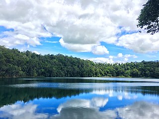
Lake Eacham is a rural locality in the Tablelands Region, Queensland, Australia. In the 2021 census, Lake Eacham had a population of 459 people.

The Tully Falls, a horsetail chute waterfall on the Tully River, is located in the UNESCO World Heritage–listed Wet Tropics in the Far North region of Queensland, Australia. It formed the eastern boundary of the Dyirbal.

The Einasleigh Uplands is an interim Australian bioregion, with vegetation consisting of savanna and woodland located on a large plateau in inland Queensland, Australia. It corresponds to the Einasleigh Uplands savanna ecoregion, as identified by the World Wildlife Fund.
Kirrama National Park is a national park in Minnamoolka, Tablelands Region of Far North Queensland, Australia. The park protects rugged mountain landscapes, lush tropical rainforest and open eucalypt forests.
Maalan National Park is a national park in the Tablelands Region of Far North Queensland, Australia. There are two sections to the park. The largest section occupies the western third of Beatrice and the eastern fringe of Ravenshoe on the Atherton Tableland. The smaller section is in the north of Maalan. It belongs to the Wet Tropics of Queensland bioregion. The park was established to protect significant animal and plant communities. The areas were previously known as Dirran State Forest. It is adjacent to Tully Gorge National Park and Mount Fisher Forest Reserve.
Millstream is a rural locality in the Tablelands Region, Queensland, Australia. In the 2021 census, Millstream had a population of 981 people.
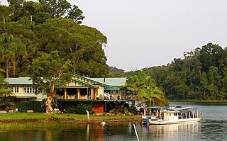
Lake Barrine is a rural locality in the Tablelands Region, Queensland, Australia. In the 2021 census, Lake Barrine had a population of 170 people.
Tumoulin is a rural town and locality in the Tablelands Region, Queensland, Australia. In the 2021 census, the locality of Tumoulin had a population of 135 people.

Danbulla is a locality in the Tablelands Region, Queensland, Australia. In the 2021 census, Danbulla had a population of 88 people.

The Windsor Tablelands are a series of plateaus located in Far North Queensland, Australia. The Windsor Tableland and surrounding rainforest area are contained as part of the Wet Tropics of Queensland, sitting between the Daintree Rainforest and Mount Lewis National Park. Additionally, the region is contained in the state electorate of Cook and situated in the greater Tablelands Region of North Queensland. The Tablelands hug the mountain ranges of the Great Dividing Range with the nearest town being Wujal Wujal. The Tableland area is a larger part of the Mount Windsor Forest Reserve which represents 44,000 hectares of land in the Wet Tropic region and is a conserved nature area, as proclaimed by the Government of Queensland in 2005. Predominately the majority of the Mount Windsor Tableland is closed off for any form of public use and access to the area is often only given on request. There is currently no residential population in the Mount Windsor Tableland region as a majority of the area is national park.
Palmerston is a rural locality split between the Tablelands Region and the Cassowary Coast Region, Queensland, Australia. In the 2021 census, Palmerston had "no people or a very low population".
References
- ↑ "Koombooloomba National Park – national park in the Tablelands Region (entry 50357)". Queensland Place Names. Queensland Government . Retrieved 12 June 2022.
- ↑ "About Koombooloomba National Park and Conservation Park". Parks and forests. Queensland Government. 2009-10-22. Archived from the original on 2022-03-29. Retrieved 2022-06-12.
- ↑ "Queensland Globe". State of Queensland . Retrieved 12 June 2022.