
Lincoln County is a county located in the U.S. state of Montana. As of the 2020 census, the population was 19,677. Its county seat is Libby. The county was founded in 1909 and named for President Abraham Lincoln. The county lies on Montana's north border and thus shares the US-Canadian border with the Canadian province of British Columbia.

Troy is a city in Lincoln County, Montana, United States. The population was 797 at the 2020 census. It lies at the lowest elevation of any settlement in Montana. The town is on U.S. Route 2, near Montana Highway 56, in the Kootenai River gorge by the Kootenai National Forest.

Libby is a city in northwestern Montana, United States and the county seat of Lincoln County. The population was 2,775 at the 2020 census.

Lake Koocanusa is a reservoir in British Columbia (Canada) and Montana formed by the damming of the Kootenai River by the Libby Dam in 1972. The Dam was formally dedicated by President Gerald Ford on August 24, 1975.
The Kootenay River or Kootenai River is a major river in the Northwest Plateau, in southeastern British Columbia, Canada, and northern Montana and Idaho in the United States. It is one of the uppermost major tributaries of the Columbia River, the largest North American river that empties into the Pacific Ocean. The Kootenay River runs 781 kilometres (485 mi) from its headwaters in the Kootenay Ranges of the Canadian Rockies, flowing from British Columbia's East Kootenay region into northwestern Montana, then west into the northernmost Idaho Panhandle and returning to British Columbia in the West Kootenay region, where it joins the Columbia at Castlegar.

The Kootenai National Forest is a national forest located in the far northwestern section of Montana and the northeasternmost lands in the Idaho panhandle in the United States, along the Canada–US border. Of the 2.2 million acres (8,900 km2) administered by the forest, less than 3 percent is located in the state of Idaho. Forest headquarters are located in Libby, Montana. There are local ranger district offices in Eureka, Fortine, Libby, Trout Creek, and Troy, Montana. About 53 percent of the 94,272-acre (381.51 km2) Cabinet Mountains Wilderness is located within the forest, with the balance lying in neighboring Kaniksu National Forest.

Libby Dam is a concrete gravity dam in the northwestern United States, on the Kootenai River in northwestern Montana. Dedicated on August 24, 1975, it is west of the continental divide, seventeen miles (27 km) upstream from the town of Libby.
Montana State Highway 37 is a 67.048-mile-long (107.903 km) state highway in the US state of Montana. It begins in downtown Libby, Montana at US 2 and takes a meandering course northeastwards upstream along the Kootenai River and the eastern shore of Lake Koocanusa before terminating at U.S. Route 93 at the northern end of Eureka, Montana. Previously, MT 37 also followed US 93 from Eureka into Whitefish and turned down what is now MT 40 towards US 2 and Glacier National Park until at least 1942.
The Fisher River is a tributary of the Kootenay River in the U.S. state of Montana. The Fisher River properly begins at the confluence of its two main tributaries, the Pleasant Valley Fisher River and the Silver Butte Fisher River. Of the two tributaries, the Pleasant Valley Fisher River is the larger and is sometimes considered part of the Fisher River proper. A variant name of the Fisher River is Pleasant Valley River, and a variant name of the Pleasant Valley Fisher River is Fisher River.
KTNY is a radio station licensed to serve Libby, Montana. The station is owned by Lincoln County Broadcasters. It airs a soft oldies music format.

Stryker is an unincorporated community and census-designated place (CDP) in Lincoln County, Montana, United States. As of the 2010 census it had a population of 26. Stryker has the 59933 ZIP code.
The Lake Koocanusa Scenic Byway is a 67-mile (108 km) scenic highway in Lincoln County, Montana, USA, following the Kootenai River and the eastern shore of Lake Koocanusa on Highway 37. The road starts in Libby and proceeds north to Eureka. Lake Koocanusa is formed behind Libby Dam and has a visitors center nearby. The Kootenai River and Lake Koocanusa cut a narrow fjord-like gorge between the Purcell Mountains and the Salish Mountains. The byway is a popular route for visitors visiting the Kootenai National Forest. Snow removal crews work to keep the route open during the winter season. Lodging and services are available in Libby and Eureka.
Yaak is an unincorporated community and census-designated place in Lincoln County, Montana, United States. It is located along the Yaak River, within the Kootenai National Forest. As of the 2020 census, its population was 338.
Pioneer Junction is a census-designated place (CDP) in Lincoln County, Montana, United States. The population was 959 at the 2010 census.
White Haven is an unincorporated community and census-designated place (CDP) in Lincoln County, Montana, United States. The population was 577 at the 2010 census.
The Kootenai is a region in the northwest of the US state of Montana encompassing the Cabinet Mountains and Lincoln County, Montana and the Kootenai National Forest. It is named after the Kootenai River. The name has been established as a social and economic development brand name by a Public-Private-Partnership between Lincoln County and the University of Montana.
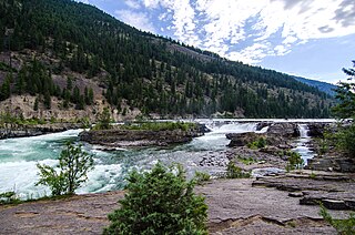
Kootenai Falls is a waterfall on the Kootenai River located in Lincoln County, Montana, just off U.S. Route 2. It is the largest undammed waterfall in the state and one of the largest waterfalls in the United States by flow rate. The falls is accessed by a foot trail from the parking area next to the highway.