Look up Kutenai in Wiktionary, the free dictionary.
Kootenay, Kootenai, and Kutenai may refer to:
Kootenay, Kootenai, and Kutenai may refer to:
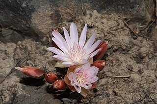
Bitterroot is a small perennial herb in the family Montiaceae. Its specific epithet rediviva refers to its ability to regenerate from dry and seemingly dead roots.

Lincoln County is a county located in the U.S. state of Montana. As of the 2020 census, the population was 19,677. Its county seat is Libby. The county was founded in 1909 and named for President Abraham Lincoln. The county lies on Montana's north border and thus shares the US-Canadian border with the Canadian province of British Columbia.

Bonners Ferry is the largest of two cities in and the county seat of Boundary County, Idaho, United States. The population was 2,543 at the 2010 census.

The Pend Oreille River is a tributary of the Columbia River, approximately 130 miles (209 km) long, in northern Idaho and northeastern Washington in the United States, as well as southeastern British Columbia in Canada. In its passage through British Columbia its name is spelled Pend-d'Oreille River. It drains a scenic area of the Rocky Mountains along the U.S.-Canada border on the east side of the Columbia. The river is sometimes defined as the lower part of the Clark Fork, which rises in western Montana. The river drains an area of 66,800 square kilometres (25,792 sq mi), mostly through the Clark Fork and its tributaries in western Montana and including a portion of the Flathead River in southeastern British Columbia. The full drainage basin of the river and its tributaries accounts for 43% of the entire Columbia River Basin above the confluence with the Columbia. The total area of the Pend Oreille basin is just under 10% of the entire 258,000-square-mile (670,000 km2) Columbia Basin. Box Canyon Dam is currently underway on a multimillion-dollar project for a fish ladder.

The Kootenay River or Kootenai River is a major river of the Northwest Plateau in southeastern British Columbia, Canada, and northern Montana and Idaho in the United States. It is one of the uppermost major tributaries of the Columbia River, the largest North American river that empties into the Pacific Ocean. The Kootenay River runs 781 kilometres (485 mi) from its headwaters in the Kootenay Ranges of the Canadian Rockies, flowing from British Columbia's East Kootenay region into northwestern Montana, then west into the northernmost Idaho Panhandle and returning to British Columbia in the West Kootenay region, where it joins the Columbia at Castlegar.

The Confederated Salish and Kootenai Tribes of the Flathead Reservation are a federally recognized tribe in the U.S. state of Montana. The government includes members of several Bitterroot Salish, Kootenai and Pend d'Oreilles tribes and is centered on the Flathead Indian Reservation.
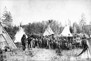
The Kutenai, also known as the Ktunaxa, Ksanka, Kootenay and Kootenai, are an indigenous people of Canada and the United States. Kutenai bands live in southeastern British Columbia, northern Idaho, and western Montana. The Kutenai language is a language isolate, thus unrelated to the languages of neighboring peoples or any other known language.
Indigenous peoples of the Northwest Plateau, also referred to by the phrase Indigenous peoples of the Plateau, and historically called the Plateau Indians are Indigenous peoples of the Interior of British Columbia, Canada, and the non-coastal regions of the Northwestern United States.

The Kootenai National Forest is a national forest located in the far northwestern section of Montana and the northeasternmost lands in the Idaho panhandle in the United States, along the Canada–US border. Of the 2.2 million acres (8,900 km2) administered by the forest, less than 3 percent is located in the state of Idaho. Forest headquarters are located in Libby, Montana. There are local ranger district offices in Eureka, Fortine, Libby, Trout Creek, and Troy, Montana. About 53 percent of the 94,272-acre (381.51 km2) Cabinet Mountains Wilderness is located within the forest, with the balance lying in neighboring Kaniksu National Forest.

The Kutenai language, also Kootenai, Kootenay, Ktunaxa, and Ksanka, is the native language of the Kutenai people of Montana and Idaho in the United States and British Columbia in Canada. It is typically considered a language isolate, unrelated to the Salishan family of languages spoken by neighboring tribes on the coast and in the interior Plateau. The Kutenai also speak ʔa·qanⱡiⱡⱡitnam, Ktunaxa Sign Language.
The Kootenai Tribe of Idaho is a federally recognized tribe of Lower Kootenai people. They are an Indigenous people of the Northwest Plateau based in northern Idaho.
The International Selkirk Loop is a 280-mile-long (450 km) scenic highway in the U.S. states of Idaho and Washington, as well as the Canadian province of British Columbia. The loop encircles the Selkirk Mountain Range, and offers several side trips aside from the main route. Included on the loop is the Kootenay Lake Ferry, the longest free ferry in the world. The portion of the loop in the United States has been designated an All-American Road by the United States Department of Transportation.

The Sinixt are a First Nations People. The Sinixt are descended from Indigenous peoples who have lived primarily in what are today known as the West Kootenay region of British Columbia in Canada and the adjacent regions of Eastern Washington in the United States for at least 10,000 years. The Sinixt are of Salishan linguistic extraction, and speak their own dialect (snsəlxcín) of the Colville-Okanagan language.
Jennifer Porter is the current tribal chair of the Kootenai Tribe of Idaho. She was born in Navajo Nation in Fort Defiance and is half Navajo and half Kootenai. She replaced her uncle on the Kootenai Tribal Council when she was 23. Porter has promoted educational and cultural programs, including a computer program to teach students words from the Kutenai language. She has three children, two of whom attend the Boundary County School District public school.
The Ktunaxa Nation or Ktunaxa Nation Council is a First Nations tribal council government comprising four Ktunaxa (Kutenai) bands in the south-east of the Canadian province of British Columbia. It is one of three Kutenai governments, the others being the Kootenai Tribe of Idaho and the Confederated Salish and Kootenai Tribes in the United States.

The Moyie River is a 92-mile (148 km) long tributary of the Kootenai River in the U.S. state of Idaho and the Canadian province of British Columbia. The Moyie River is part of the Columbia River basin, being a tributary of the Kootenay River, which is a tributary to the Columbia River.
Elko is located at the junction of Highway 93 and the Crowsnest Highway, to the north of the Roosville Canada–United States border crossing. A small sawmill town, Elko is situated near the southern end of the Rocky Mountain Trench at the edge of a plateau at the base of the Canadian Rockies, in the East Kootenay region of southeastern British Columbia.
The Lower Kootenay First Nation is a First Nation based in the East Kootenay region of British Columbia. In the British Columbia Treaty Process They are part of the Ktunaxa Kinbasket Tribal Council.
The Tobacco Plains Indian Band are a First Nation based in the East Kootenay region of British Columbia. In the British Columbia Treaty Process They are part of the Ktunaxa Kinbasket Tribal Council.
The Dutch Creek Hoodoos are located in British Columbia, Canada, and can be seen along British Columbia Highway 93/British Columbia Highway 95 between Canal Flats and Fairmont Hot Springs, British Columbia. The Dutch Creek Hoodoos are within a 67-acre conservation area that is managed by the Natural Conservancy of British Columbia. This conservation area is joined by the Nature Trust Hoffert Property and they both act as a habitat for varying plants and animals including the American badger, Lewis's woodpecker, the Hooker's Townsendia, Eagle, and Hawk. The Dutch Creek Hoodoos can be further discovered by following the 4.6 mile trail that faces an elevation gain of 95 meters over the course of the trail.