
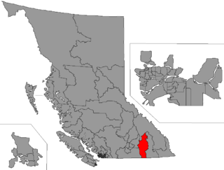
Kootenay—Columbia is a federal electoral district in British Columbia, Canada, that has been represented in the House of Commons of Canada since 1997.

British Columbia Southern Interior was a federal electoral district in the province of British Columbia, Canada, that had been represented in the House of Commons of Canada from 1997 to 2015.
Cariboo was a federal electoral district in British Columbia, Canada, that was represented in the House of Commons of Canada from 1871 to 1892.
Yale was a federal electoral district in British Columbia, Canada, that was represented in the House of Commons of Canada from 1872 to 1892 and from 1917 to 1953.
Yale–Cariboo was a federal electoral district in British Columbia, Canada, that was represented in the House of Commons of Canada from 1896 to 1917.
Kootenay East was a federal electoral district in British Columbia, Canada, that was represented in the House of Commons of Canada from 1917 to 1968 and from 1979 to 1997.
Kamloops was a federal electoral district in British Columbia, Canada, that was represented in the House of Commons of Canada from 1935 to 1968, and from 1988 to 2004. From 1998 to 2004, it was known as Kamloops, Thompson and Highland Valleys.
Okanagan Boundary was a federal electoral district in British Columbia, Canada, that was represented in the House of Commons of Canada from 1953 to 1979.
Okanagan—Revelstoke was a federal electoral district in British Columbia, Canada, that was represented in the House of Commons of Canada from 1953 to 1968.
Okanagan North was a federal electoral district in the province of British Columbia, Canada, that was represented in the House of Commons of Canada from 1979 to 1988.
Okanagan—Similkameen was a federal electoral district in British Columbia, Canada, that was represented in the House of Commons of Canada from 1979 to 1988.
Kootenay West—Revelstoke was a federal electoral district in British Columbia, Canada, that was represented in the House of Commons of Canada from 1988 to 1997. This riding was created in 1987 from Kootenay West riding. It was eliminated in 1996 when it was merged into the new riding of West Kootenay—Okanagan.
Okanagan—Similkameen—Merritt was a federal electoral district in British Columbia, Canada, that was represented in the House of Commons of Canada from 1988 to 1997.
Boundary-Similkameen is a provincial riding formed in 2008. It includes the populations of Penticton-Okanagan Valley, West Kootenay-Boundary and Yale-Lillooet. The riding's name corresponds to that of a former riding in the same area, with similar but not identical boundaries.
Rossland-Trail was the name of a provincial electoral district in the Canadian province of British Columbia centred on the towns of Rossland and Trail, in the West Kootenay. The riding first appeared in the 1924 election as the result of a redistribution of the former ridings of Greenwood and Trail, and lasted until redistribution in 1996. The same area is now part of West Kootenay-Boundary.
Okanagan-Boundary was a provincial electoral district in the Canadian province of British Columbia spanning the area from the Similkameen towns of Kaleden and Keremeos to Grand Forks and Christina Lake, and including the southern Okanagan towns of Okanagan Falls, Oliver, Osoyoos, Rock Creek and Greenwood. The riding first appeared in the 1991 election as the result of a redistribution of the former riding of Boundary-Similkameen. The same area is now part of West Kootenay-Boundary.
The Boundary Country is a historical designation for a district in southern British Columbia lying, as its name suggests, along the boundary between Canada and the United States. It lies to the east of the southern Okanagan Valley and to the west of the West Kootenay. It is often included in descriptions of both of those regions but historically has been considered a separate region. Originally inclusive of the South Okanagan towns of Osoyoos and Oliver, today the term continues in use to refer to the valleys of the Kettle, West Kettle, and Granby Rivers and of Boundary and Rock Creeks and that of Christina Lake and of their various tributaries, all draining the south slope of the Monashee Mountains The term Boundary District as well as the term Boundary Country can both refer to the local mining division of the British Columbia Ministry of Mines, Energy and Petroleum Resources.
Kootenay West is a provincial electoral district in British Columbia, Canada, established by the Electoral Districts Act, 2008. It was first contested in the 2009 general election.

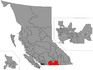
South Okanagan—West Kootenay is a federal electoral district in British Columbia. It encompasses a portion of British Columbia previously included in the electoral districts of British Columbia Southern Interior (58%), Kootenay—Columbia (3%), and Okanagan—Coquihalla (39%).