
The Arctic Archipelago, also known as the Canadian Arctic Archipelago, is a group of islands north of the Canadian mainland.

Plesetsk Cosmodrome is a Russian spaceport located in Mirny, Arkhangelsk Oblast, about 800 km north of Moscow and approximately 200 km south of Arkhangelsk, dates from 1957. Originally developed as an ICBM site for the R-7 missile, it also served for numerous satellite launches using the R-7 and other rockets. Its high latitude makes it useful only for certain types of launches, especially the Molniya orbits, so for much of the site's history it functioned as a secondary location, with most orbital launches taking place from Baikonur, in the Kazakh SSR. With the end of the Soviet Union, Baikonur became foreign territory, and Kazakhstan charged $115 million usage fees annually. Consequently, Plesetsk has seen considerably more activity since the 2000s.

Koporye is a historic village (selo) in Leningrad Oblast, Russia, located about 100 km (62 mi) to the west of St. Petersburg and 12 km (7.5 mi) south of the Koporye Bay of the Baltic Sea. It contains some of the most impressive medieval ruins in Russia.

The Chorna, Chornaya or Chorhun River, which translates from the Ukrainian and Russian as "Black River", is a small river in Crimea. Its length is 34.5 km.
Hosororo is a community in the Barima-Waini region of northern Guyana, on the west bank of the Aruka River, 10 km (6.2 mi) from the river's mouth, and three miles from Mabaruma.
Pulkovo Heights is a chain of hills located to the south of Saint Petersburg. They run to the south-west in the direction of the Izhora Plateau and have an altitude of up to 73 meters.
German submarine U-554 was a Type VIIC U-boat of Nazi Germany's Kriegsmarine during World War II. The submarine was laid down on 1 December 1939 at the Blohm & Voss yard in Hamburg as yard number 530, launched on 7 November 1940, and commissioned on 15 January 1941 under the command of Kapitänleutnant Dietrich Lohmann.
Bolshoi Tyuters is an island in the Gulf of Finland of the Baltic Sea, located 75 km (47 mi) away from the coast of Finland, to the south-east from Hogland. The island is a part of the Leningrad Oblast, Russia. The area is approximately 8.3 km2 (3.2 sq mi). There are no permanent inhabitants, save for a lighthouse keeper.
German submarine U-362 was a Type VIIC U-boat built for Nazi Germany's Kriegsmarine for service during World War II.

Ashūradeh, or Ashur Ada, is the only island of the Iranian coast of the Caspian Sea. Ashuradeh's surface is 800 hectares .
It is located on the eastern end of the Miankaleh peninsula in the county of Behshahr of Māzandarān Province of Iran, 3 kilometers (1.9 mi) from Bandar Torkaman and 23 kilometers (14 mi) from Gorgan.
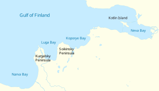
The Luga Bay is a shallow bay near the southern Russian coast of the Gulf of Finland. It is free of ice 326 days a year. Kurgalsky Peninsula separates the bay from the Bay of Narva to the west, while the Soikinsky Peninsula separates it from the Koporye Bay to the east. The Luga River empties into the bay near Ust-Luga.
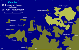
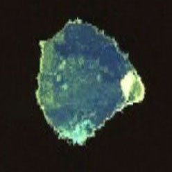
Kolosovykh Island is an island, in the Kara Sea off the coast of Siberia.
German submarine U-479 was a Type VIIC U-boat built for Nazi Germany's Kriegsmarine for service during World War II.
She was laid down at the Deutsche Werke in Kiel on 19 November 1942 as yard number 310, launched on 14 August 1943 and was commissioned on 27 October 1943 with Oberleutnant zur See Hans-Joachim Förster, a Knights Cross winner, in command. He was replaced shortly afterwards by Oberleutnant Friedrich-Wilhelm Sons.
The Narva Bay is a bay in the southern part of the Gulf of Finland divided between Estonia and Russia. The Kurgalsky Peninsula separates it from the Luga Bay to the east. The bay is about 40 kilometres (25 mi) long and 90 kilometres (56 mi) wide at its mouth. The eastern shore is low and sandy, while the south coast is rather steep. The bay is covered by ice from December to March. The Narva River flows into the bay near the town of Narva-Jõesuu.
The Soikinsky Peninsula in Kingiseppsky District, Leningrad Oblast, Russia projects out into the Gulf of Finland, separating the Luga Bay from the Koporye Bay. Its name is derived from Soikkola, which is the Izhorian word for "peninsula".

Soquel Canyon State Marine Conservation Area (SMCA) is an offshore marine protected area in Monterey Bay. Monterey Bay is on California’s central coast with the city of Monterey at its south end and the city of Santa Cruz at its north end. The SMCA covers 23.41 square miles (60.6 km2). Within the SMCA, fishing and taking of any living marine resources is prohibited except the commercial and recreational take of pelagic finfish.
Voskresensk is the name of several inhabited localities in Russia.

The Battle of Koporye took place on October 8, 1708 close to Koporye, in the Swedish Empire during the Ingrian campaign in the Great Northern War. A Swedish force consisting of 1,800 men under the command of generals Carl Gustaf Armfeldt and Anders Erik Ramsay attacked a numerically stronger enemy of between 2,000 and 3,000 Russian forces. The battle ended in a Swedish victory with about 600 killed Russians and only 70 dead for the Swedish force. After some further campaigning, the Swedish–Finland army under the command of Georg Lybecker decided to evacuate his troops, having failed with his objectives.

German submarine U-1210 was a Type VIIC U-boat of Nazi Germany's Kriegsmarine during World War II.


