Transport
It is served by a station on the Dakar-Niger Railway extending past Bamako.
Korofina is a town in Mali, close enough to the capital Bamako to be a suburb.
It is served by a station on the Dakar-Niger Railway extending past Bamako.


Mali, a large, landlocked, multicultural country in West Africa, consistently ranks low in the Human Development Index. The infrastructure of Communications in Mali, while underdeveloped, is crucial to the nation.

Mali's transportation infrastructure is regarded as poor, even by regional standards, and deficiencies have limited economic growth and development. Nevertheless, improvements have been noted in the early 2000s. Most of the transportation in Mali consists of cars, planes, and boats.

Bamako is the capital and largest city of Mali, with a population of 1,810,366. In 2006, it was estimated to be the fastest-growing city in Africa and sixth-fastest in the world. It is located on the Niger River, near the rapids that divide the upper and middle Niger valleys in the southwestern part of the country.

Kayes is a city in western Mali on the Sénégal River, with a population of 127,368 at the 2009 census. Kayes is the capital of the administrative region of the same name. The name "Kayes" comes from the Soninké word "karré", which describes a low humid place that floods in rainy season. The city is located 420 kilometres (260 mi) northwest of the capital Bamako.
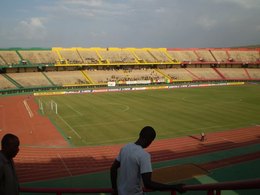
Stade du 26 Mars is located in the southern neighborhoods of Bamako, Mali. It serves as a home ground for domestic football club Stade Malien and is the national stadium. It has a capacity of 50,000 as an all-seater stadium. Built in 2001, it is named for the date of Martyrs' Day (Mali), a national commemoration of the 26 March 1991 Bamako uprising which overthrew the dictatorship of Moussa Traoré. The stadium, which is built by China Overseas Engineering Group, serves as a venue for 2002 African Cup of Nations.

The Dakar–Niger Railway connects Dakar, Senegal to Koulikoro, Mali. The name refers to the Niger River, not the Republic of Niger. It serves many cities in Senegal, including Thiès, and in Mali, including Kayes, Kita, Kati, Bamako. The line covers a course of 1,287 km of which 641 km lies in Mali. The line is managed by the Transrail consortium.
The media of Mali includes print, radio, television, and the Internet.

Bamako Grand Mosque is a mosque in the city centre of Bamako, Mali. Built on the site of a pre-colonial mud-brick mosque, the current mosque was built through funding from the Saudi Arabian government at the end of the 1970s. One of the tallest structures in Bamako, it is situated north of the Niger River near the central market and the colonial-era Bamako Cathedral. With its tall cement minarets built around a square central structure, the building is stylistically closer to Saudi religious structures than West African. The mosque is visible from much of the city and is occasionally opened to tourists.

Kati Cercle is an administrative subdivision of the Koulikoro Region of Mali. Its seat is the town of Kati, which is also its largest town. It lies at the southwest corner of the region, and completely surrounds the Bamako Capital District. Until the capital was hived off in 1977, the combined Cercle was called Bamako Cercle, with the capital city as its seat.
Railway stations in Mali include:
The King Fahd Bridge of Bamako, Mali connects the older sections of the Malian capital to its broad suburbs on the south shore of the Niger River.

The Martyrs Bridge of Bamako, Mali connects the older sections of the city to its suburbs on the south shore of the Niger River. One of two road bridges across the Niger at Bamako, it is also known as the "Old Bridge". Opened in 1957 when Mali was under French colonial rule, it was renamed the Martyrs Bridge after independence in 1961. Martyrs Bridge connects two of the main avenues of the city. Avenue Fleuve, a broad boulevard enclosing the Square Lamumba which runs north towards the Presidential palace. From the south of the bridge runs Avenue de l'Unite Africain, the major route from the city centre south to Bamako-Senou Airport.
Mali has only one railway, the Dakar-Niger Railway, which includes 729 kilometers in Mali and runs from the port of Koulikoro via Bamako to the border with Senegal and continues on to Dakar. The track gauge is 1,000 mm.

Shalingzi railway station is a station of Jingbao Railway in Hebei.
In an attack on March 7, 2015, five people were shot dead and nine wounded in a restaurant on a busy street of Bamako, the capital of Mali. Two of those killed were Malians, and the others French and Belgian respectively.
The Embassy of France in Bamako is the diplomatic mission of France to Mali. It is in Patrice Lumumba Square in Bamako, the capital of Mali. As of 2015, the French ambassador to Mali was Gilles Huberson.

The Sacred Heart Cathedral is located in Bamako, the capital of Mali it serves as the cathedral of the Archdiocese of Bamako.
The following is a timeline of the history of the city of Bamako, Mali.
Coordinates: 12°40′19″N07°55′48″W / 12.67194°N 7.93000°W
| This Mali location article is a stub. You can help Wikipedia by expanding it. |