Public (closed to visitors during monsoon season; typically from 15th June to 31st October)
Kotumsar Cave is a limestone cave located near Jagdalpur in the Indian state of Chhattisgarh. It is situated on the Kanger limestone belt close to the bank of the Kanger River and lies within Kanger Valley National Park. The cave contains a main tunnel of approximately 200 metres with several lateral and downward passages. It is the longest cave present in Indian subcontinent.[1]
The cave is subject to seasonal flooding during the monsoon, typically from mid-June to mid-October or early November; the authorities close the site to visitors during the high‑water period. Several permanent and seasonal pools occur within the cave system.
Kotumsar Cave is located within the historic and legendary forest region of Dandakaranya, which holds significant cultural and mythological importance in Indian traditions and texts such as the Ramayana.
Location and physical characteristics
The cave entrance is at approximately 18°52′09″N81°56′05″E / 18.86917°N 81.93472°E / 18.86917; 81.93472 and the site lies at an elevation of about 560 m above sea level. A vertical fissure in the hill provides the main access; a concrete path has been provided along the principal visitor route. Air and water temperatures within the cave are relatively stable. One study reported annual mean air and water temperatures of 28.25 ± 1.23 °C and 26.33 ± 0.96 °C, respectively (air range = 25.0–32.7 °C; water range = 22.9–29.3 °C).[2]
Human use and religion
According to the Ramayana and local folklore, it is believed that Lord Rama, Sita, and Lakshmana spent a considerable part of their exile in the forests of Dandakaranya, and Kotumsar Cave is traditionally associated with their stay. Some formations inside the cave—such as flat rock surfaces resembling beds, raised platforms, and ceiling marks resembling eyes—are interpreted by devotees as signs of ancient habitation. At the end of the cave, there is a stalagmite revered as a Shivling, which, according to local belief, was established by Lord Rama himself and worshipped daily during his exile. Nearby stands a natural stone pillar that produces a bell-like sound when struck, adding to the cave's spiritual atmosphere.[3]
Kotumsar Cave is considered to be both deep and extensive, and parts of its network are still unexplored. Ongoing studies continue to reveal new passages and features, indicating that sections of the cave remain scientifically uncharted and may hold further geological or archaeological interest.[4]
History of exploration
The cave was recorded during the colonial (British) period, but more systematic exploration and scientific study began in the mid‑20th century. In the 1950s, Dr. Shankar Tiwari conducted early exploratory visits and in the 1980s, Jayant Biswas (then a doctoral student) produced the first systematic map of the cave; this mapping was carried out with guidance from an experienced international caver and was later published in academic outlets.[5]
New chamber
In 2011, forest officials reported the discovery and survey of a small chamber with notable interior morphology. Because access is difficult, this chamber has not been opened for routine tourist visits.
Access
Kotumsar Cave is located within Kanger Valley National Park, approximately 35 km from the city of Jagdalpur. Jagdalpur is connected by road, rail and air: the nearest airport is Maa Danteshwari Airport, Jagdalpur. The cave lies about few km from the national park's main entrance along the NH 30/ Jagdalpur–Sukma route; visitors should consult park authorities for access conditions and seasonal closures.
Biodiversity and scientific importance
Kotumsar Cave is one of the better studied caves in India in terms of its biological communities. Surveys of the cave fauna began in the mid‑20th century and have recorded a number of troglobitic (obligate cave) and troglophilic (cave‑associated) taxa. Notable records include the blind cavefish Indoreonectes evezardi (formerly placed in Nemacheilus), and several cave‑adapted arthropods, including a cricket described as Kempiola shankari (named in honour of Dr Shankar Tiwari).[6]
Microbiological studies and surveys of other invertebrates have also been undertaken by researchers and organisations interested in subterranean ecology; summaries and taxon‑specific reviews have been published in the scientific literature.[7]
This page is based on this Wikipedia article Text is available under the CC BY-SA 4.0 license; additional terms may apply. Images, videos and audio are available under their respective licenses.


 Stalactite inside the Cave
 Stairway inside Cave
 Shivling inside Cave
 Biospeleologist in search of biodiversity inside the cave
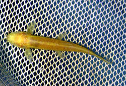 The blind fish found inside the cave
 Hylarana malabarica inside the Cave
 Inside view of Cave


