
Dakar is the capital and largest city of Senegal. The department of Dakar has a population of 1,278,469, and the population of the Dakar metropolitan area was at 4.0 million in 2023.
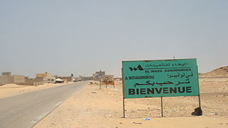
Nouadhibou is the second largest city in Mauritania and serves as a major commercial center. The city has about 173,000 inhabitants. It is situated on a 65-kilometre peninsula or headland called Ras Nouadhibou, Cap Blanc, or Cabo Blanco, of which the western side has the city of La Güera. Nouadhibou is consequently located merely a couple of kilometers from the border between Mauritania and Western Sahara. Its current mayor is Elghassem Ould Bellali, who was installed on 15 October 2018.

Épinay-sur-Orge is a commune in the Essonne department in Île-de-France in northern France.
Kayes is a city in western Mali on the Sénégal River with a population of 127,368 at the 2009 census. Kayes is the capital of the administrative region of the same name. The city is located 420 kilometres (260 mi) northwest of the capital Bamako.

Tambacounda is the largest city in eastern Senegal, 400 kilometres (250 mi) southeast of Dakar, and is the regional capital of the province of the same name. Its population in 2023 was 149,071.
Diourbel is a town and urban commune in Senegal lying east of Thiès. It is known for its mosque and local groundnut industry and is the capital of the Diourbel Region. The population in 2023 was 157,554.
Joal-Fadiouth is a town and urban commune in the Thiès Region at the end of the Petite Côte of Senegal, south-east of Dakar.

Rosso is the major city of south-western Mauritania and capital of Trarza region. It is situated on the Senegal River at the head of the river zone allowing year-round navigation.

Louga is a city in northwestern Senegal. Louga is a cattle market centre, and has road and rail links with the port city of Saint-Louis to the northwest and Dakar to the southwest. The area surrounding Louga is at the northern limits of Senegal's peanut- (groundnut-) growing area and is inhabited by the Fulani, who are generally pastoral nomads, and the Wolof, who are sedentary farmers. Louga is located in what is called the Ndiambour, which used to be part of the Cayor province.
Matam is the capital town of the Matam Region in north-east Senegal, and lies on the Sénégal River on the border with Mauritania. In the census of 2002, Matam had 14,620 inhabitants and in the 2023 census the population of the town had increased to 27,695.
Linguère is a town and urban commune located in the Linguère Department, Louga Region of Senegal.

Kaffrine is the capital town of Kaffrine Region of Senegal.
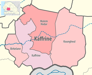
Koungheul is the name of one of 46 departments of Senegal, as well as the name of Koungheul Arrondissement and the commune of Koungheul, the principal settlement of the department.
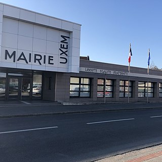
Uxem is a commune in the Nord department in northern France.

Les Arcs is a commune in the Var department in the Provence-Alpes-Côte d'Azur region in Southeastern France.
Mignaloux-Beauvoir is a commune from the Center-West of France, located in the south-eastern suburbs of Poitiers, in the Vienne department in Nouvelle-Aquitaine region.
Bargny is a settlement and urban commune in Senegal. It is located in a somewhat sheltered bay about 15 km to the east of the capital, Dakar.

Boghé is a town and commune in the Brakna Region of southern Mauritania, located on the border with Senegal.

The Communes of Senegal are the fourth-level administrative divisions in Senegal. There are some 121 communes in Senegal which have urban status, apart from 46 communes d'arrondissement in the large towns and 370 rural communities in the countryside.

Sidi Khellil is a town and commune in El M'Ghair District, El M'Ghair Province, Algeria. According to the 2008 census it has a population of 6,547, up from 5,524 in 1998, and an annual growth rate of 1.7%.
