Kent is an unincorporated community in Nassau County, Florida, United States. It is located on State Road 2, in the southwestern part of the county.
La Herrera is a municipality in Albacete, Castile-La Mancha, Spain. It has a population of 390.

Fisterra is a comarca in the Galician Province of A Coruña. The overall population of this local region is 24,466 (2005).

Putlur is a village in Anantapur district of the Indian state of Andhra Pradesh. It is the mandal headquarters of Putlur mandal in Anantapur revenue division.
Cotanes del Monte is a municipality located in the province of Zamora, Castile and León, Spain. According to the 2009 census (INE), the municipality has a population of 129 inhabitants.

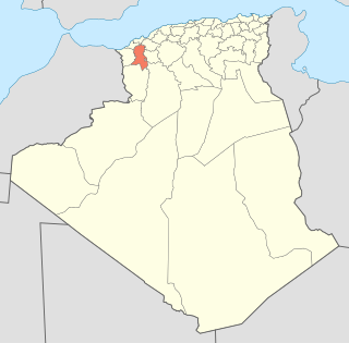
Aïn Tallout District is a district of Tlemcen Province in north-western Algeria.
San Patricio is a town and district located in the Misiones department in Paraguay.
Tupchi is a village in Bamyan Province, Afghanistan.

Tepetzintla (municipality) is a town and municipality in Puebla in south-eastern Mexico.
Tetela de Ocampo Municipality is a municipality in Puebla in south-eastern Mexico.
Moulay Slissen District is a district of Sidi Bel Abbès Province, Algeria.
Limón is a corregimiento in Colón District, Colón Province, Panama with a population of 4,665 as of 2010. Its population as of 1990 was 3,209; its population as of 2000 was 4,092.
Llano Bonito is a corregimiento in Chitré District, Herrera Province, Panama with a population of 9,798 as of 2010. It was created by Law 58 of July 29, 1998, owing to the Declaration of Unconstitutionality of Law 1 of 1982. Its population as of 2000 was 8,088.
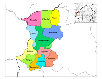
Chepo is a corregimiento in Las Minas District, Herrera Province, Panama with a population of 1,415 as of 2010. Its population as of 1990 was 1,457; its population as of 2000 was 1,452.
La Colorada is a corregimiento in Los Santos District, Los Santos Province, Panama with a population of 1,030 as of 2010. Its population as of 1990 was 987; its population as of 2000 was 1,010.
Las Guabas is a corregimiento in Los Santos District, Los Santos Province, Panama with a population of 677 as of 2010. Its population as of 1990 was 1,539; its population as of 2000 was 693.
Caimito is a corregimiento in Capira District, Panamá Oeste Province, Panama with a population of 1,635 as of 2010. Its population as of 1990 was 1,319; its population as of 2000 was 1,438.
El Potrero is a corregimiento in Calobre District, Veraguas Province, Panama with a population of 635 as of 2010. Its population as of 1990 was 687; its population as of 2000 was 650.
Llano de Catival o Mariato is a corregimiento in Mariato District, Veraguas Province, Panama with a population of 2,376 as of 2010. It is the seat of Mariato District. Its population as of 1990 was 2,052; its population as of 2000 was 2,269.
Canto del Llano is a corregimiento in Santiago District, Veraguas Province, Panama with a population of 13,331 as of 2010. It was created by Law 1 of January 7, 1993. Its population as of 2000 was 23,654.