Related Research Articles
The history of Senegal is commonly divided into a number of periods, encompassing the prehistoric era, the precolonial period, colonialism, and the contemporary era.

Tambacounda is the largest city in eastern Senegal, 400 kilometres (250 mi) southeast of Dakar, and is the regional capital of the province of the same name. Its estimated population in 2007 was 78,800.

Thiès is the third largest city in Senegal with a population officially estimated at 320,000 in 2005. It lies 72 km (45 mi) east of Dakar on the N2 road and at the junction of railway lines to Dakar, Bamako and St-Louis. It is the capital of Thiès Region and is a major industrial city.

The Dakar–Niger Railway connects Dakar, Senegal to Koulikoro, Mali. The name refers to the Niger River, not the Republic of Niger. It serves many cities in Senegal, including Thiès, and in Mali, including Kayes, Kita, Kati, Bamako. The line covers a course of 1,287 km of which 641 km lies in Mali. The line is managed by the Transrail consortium.

Rufisque is a city in the Dakar region of western Senegal, at the base of the Cap-Vert Peninsula. It has a population of 179,797. In the past it was an important port city in its own right, but is now a suburb of Dakar.
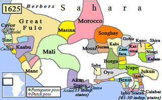
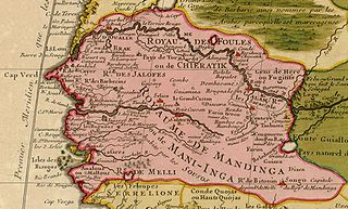
Kaabu (1537–1867), also written Gabu, Ngabou, and N'Gabu, was a federation of Mandinka kingdoms in the Senegambia region centered within modern northeastern Guinea-Bissau, large parts of today's Gambia, and extending into Koussanar, Koumpentoum, and the Casamance in Senegal.
The Esk'etemc First Nation, also known as the Alkali Lake Indian Band, is a First Nations government of the Secwepemc (Shuswap) people, located at Alkali Lake in the Cariboo region of the Central Interior of the Canadian province of British Columbia. It was created when the government of the then-Colony of British Columbia established an Indian reserve system in the 1860s. It is one of three Secwepemc bands that is not a member of either the Shuswap Nation Tribal Council or the Northern Shuswap Tribal Council.
The Kingdom of Sine was a post-classical Serer kingdom along the north bank of the Saloum River delta in modern Senegal. The inhabitants are called Siin-Siin or Sine-Sine.
Tiramakhan Traore was a 13th-century general in the Mali Empire who served under Sundiata Keita. Traore expanded the power of Mali westward and set up the Kabu Empire. In his conquest of the region, he is reported to have defeated the Bainuk king Kikikor and annexed his state. The Guelowar royal family, including the royal family of Kaabu prior to their defeat at the Battle of Kansala, claimed descent from Tiramakhan Traore.
List of Railway stations in Senegal include:
Hann is a neighbourhood of Dakar, the capital of Senegal. It is located on the eastern side of the small south facing peninsula on which the old city of Dakar was built. Hann neighborhood sits along a crescent shaped beach called Hann Bay. Hann is part of the Hann Bel-Air commune d'arrondissement: a part of the municipal Dakar Department which covers the city of Dakar. Hann is one of the four original Lebou villages of the Cap-Vert Peninsula, along with Yoff, Ngor, and Ouakam.
Barrow Kunda is a town in the Gambia. It is located in Wuli District in the Upper River Division. According to tradition the village was founded in the 16th century by Alai Bah, a marabout from Futa Toro. The king of Wuli at the time, Mansa Jalali Wali convinced him to settle there by promising him autonomy to practice Islam and protection from search and seizure.

Senegal's rail network consists of 906 km of railway at 1,000 mm gauge, and 36 km of 1,445 mm gauge. The metre-gauge network is part of the Dakar–Niger Railway which crosses the border to Mali. The railway is operated by Transrail, managed by the Belgian company Vecturis.
Guelowar, also spelled Gelwar, Guelwar, Guelware, Gueleware or Gueloware, was a maternal dynasty in the pre-colonial Serer kingdoms of Sine and Saloum. They were from the Mandinka ethnic group. The offspring of Mandinka women and Serer men became the kings of Sine and Saloum. The dynasty lasted from the mid-14th century to 1969, the year both kings died.

The medieval history of the Serer people of Senegambia is partly characterised by resisting Islamization from perhaps the 11th century during the Almoravid movement, to the 19th century Marabout movement of Senegambia and continuation of the old Serer paternal dynasties.

Joof or Diouf is a surname that is typically Serer. This surname is also spelt Juuf or Juf.
This is a timeline of the history and development of Serer religion and the Serer people of Senegal, The Gambia and Mauritania. This timeline merely gives an overview of their history, consisting of calibrated archaeological discoveries in Serer countries, Serer religion, politics, royalty, etc. Dates are given according to the Common Era. For a background to these events, see Roog, Serer religion, Serer creation myth, Serer prehistory, Lamane, States headed by Serer Lamanes, Serer history and Serer people.
Maad a Sinig Maysa Wali Jaxateh Manneh was a king described in the oral tradition of the Serer pre-colonial Kingdom of Sine and the first of the Guelowar maternal dynasty to rule in Serer country. He reigned as Maad a Sinig from c. 1350 to 1370.

Lingeer Fatim Beye Joos Fadiou was a 14th-century Serer princess and queen (Lingeer) from the Kingdom of Sine. She is the matriarch and early ancestor of the Joos Maternal Dynasty of Waalo. She is usually regarded by some sources as the founder of the Joos Maternal Dynasty. The pre-colonial Kingdoms of Sine and Waalo now lies within present-day Senegal. Her surname is Beye (English-Gambia) or Bèye (French-Senegal). Joos Fadiou is her maternal clan. In Serer, "Fa-tim" means "the maternal clan of..."
The Joos Maternal Dynasty was a Serer maternal dynasty which originated from the Serer pre-colonial Kingdom of Sine in the 14th century and spread to the Wolof Kingdom of Waalo. The matriarch or founder of this maternal dynasty was Lingeer Fatim Beye, a princess and queen originally from the Kingdom of Sine. In Waalo, it was founded by the princess Lingeer Ndoye Demba of Sine. Lingeer Ndoye Demba was the maternal granddaughter of Lingeer Fatim Beye. They both came from the Serer ethnic group. Although the pre-colonial Kingdoms of Sine and Waalo now form part of modern-day Senegal, in pre-colonial Senegambia, present-day Gambia had open-borders with Senegal and share the same historical and cultural heritage. The demarcation of the two countries is purely geographical due to their colonial past, with Britain colonizing the Gambia and France colonizing Senegal. For a background to these events see the History of Senegal, History of the Gambia, Senegambia and Timeline of Serer history.
References
- ↑ Galloway, Winifred (1975). A History of Wuli from the Thirteenth to the Nineteenth Century (History PhD). University of Indiana. p. 132.
13°52′00″N14°05′00″W / 13.86667°N 14.08333°W
| | This Senegal location article is a stub. You can help Wikipedia by expanding it. |