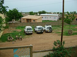
Kayes is a city in western Mali on the Sénégal River with a population of 127,368 at the 2009 census. Kayes is the capital of the administrative region of the same name. The city is located 420 kilometres (260 mi) northwest of the capital Bamako.

Tambacounda is the largest city in eastern Senegal, 400 kilometres (250 mi) southeast of Dakar, and is the regional capital of the province of the same name. Its population in 2023 was 149,071.
Diourbel is a town and urban commune in Senegal lying east of Thiès. It is known for its mosque and local groundnut industry and is the capital of the Diourbel Region. The population in 2023 was 157,554.
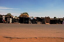
Bakel is a town and urban commune, with a population of 18,939, located in the eastern part of Senegal, West Africa. The town is located on the left bank of the Sénégal River, 65 kilometers (40 mi) from the Malian border and linked by canoe ferry to the village of Gouraye in Mauritania.

The Falémé River is a river in West Africa. The Falémé arises in northern Guinea and flows in a north-northeast direction to Mali, forming a short portion of the border between Guinea and Senegal. It turns north and then forms a portion of the border between Mali and Senegal, before joining the Sénégal River 50 km upstream of the town of Bakel in Senegal.

Bambouk is a traditional name for the territory in eastern Senegal and western Mali, encompassing the Bambouk Mountains on its eastern edge, the valley of the Faleme River and the hilly country to the east of the river valley. It was a formally described district in French Sudan, but in 1895, the border between French Sudan and Senegal was moved to the Faleme River, placing the western portion of the district within Senegal. The term is still used to designate the region, but there is no formal administrative area with that name.
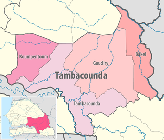
Bakel department is one of the 46 departments of Senegal and one of the four making up the Tambacounda region in the east of the country. The department had an area of 22,378 km² and population estimate at 215,680 in 2005. However, in 2008 the department was split to form the new department of Goudiry, so the area was reduced to estimated 6,290 km².
List of Railway stations in Senegal include:
Railway stations in Mali include:
Tafacirga is a village and commune in the Cercle of Kayes in the Kayes Region of south-western Mali. The commune lies at the northeast corner of the Kayes Region with the Senegal River to the north forming the frontier with Mauritania and the River Falémé to the east forming the frontier with Senegal. In 2009 the commune had a population of 7,491.
Samé or Samé Diomgoma is a village and commune in the Cercle of Kayes in the Kayes Region of south-western Mali. The commune includes 18 villages and lies to the south of the Senegal River. The Dakar-Niger Railway passes through Samé. In 2009 the commune had a population of 12,820.
Fégui is a town and urban commune in the Cercle of Kayes in the Kayes Region of south-western Mali. The town lies on the bank of the Falémé River that marks the boundary between Mali and Senegal. In 2009 the commune had a population of 5,494.
Diboli is a small town and principal settlement of the commune malienne, of département de la Gadiaga, in the Cercle of Kayes in the Kayes Region of south-western Mali. It is located just 0.6 km (0.37 mi) from the Mali–Senegal border. Its nearest big town is Kidira, across the border in Senegal.

The Communes of Senegal are the fourth-level administrative divisions in Senegal. There are some 121 communes in Senegal which have urban status, apart from 46 communes d'arrondissement in the large towns and 370 rural communities in the countryside.

Senegal's rail network consists of 906 km of railway at 1,000 mm gauge, and 36 km of 1,445 mm gauge. The metre-gauge network is part of the Dakar–Niger Railway which crosses the border to Mali. The railway is operated by Transrail, managed by the Belgian company Vecturis.
Diabougou is a village in the Tambacounda Region of eastern Senegal, near the border with Mali. The village is north of the town of Kidira and its major transport links, and close to the Falémé River. The village has grown rapidly since 2006 due to the thousands of immigrant miners attracted by a local gold rush. Diabougou has the largest informal gold mining operation in Senegal.
Diawara is a town and urban commune in Tambacounda Region of eastern Senegal, lying in the Senegal river valley near the Malian border. Its population in 2023 was 12,147.
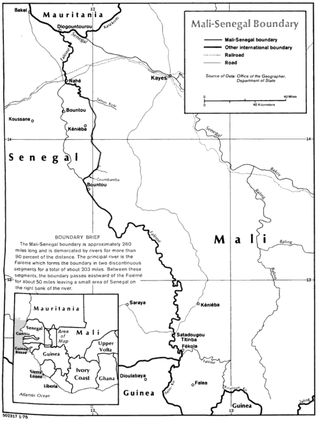
The Mali–Senegal border is 489 km in length and runs from the tripoint with Mauritania in the north to the tripoint with Guinea in the south.