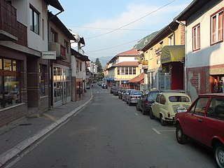
Kovačevac (Prijepolje)

Last updated
Kovačevac
Ковачевац
Village
Serbia adm location map.svg
Red pog.svg
Kovačevac
Coordinates: 43°20′N19°38′E / 43.333°N 19.633°E / 43.333; 19.633
CountryFlag of Serbia.svg  Serbia
District Zlatibor District
Municipality Prijepolje
Population (2002)
  Total 1,613
Time zone CET (UTC+1)
  Summer (DST) CEST (UTC+2)

Kovačevac (Serbian Cyrillic : Ковачевац) is a village in the municipality of Prijepolje, Serbia. According to the 2002 census, the village has a population of 1,613 people. [1]

The Serbian Cyrillic alphabet is an adaptation of the Cyrillic script for Serbo-Croatian, developed in 1818 by Serbian linguist Vuk Karadžić. It is one of the two alphabets used to write standard modern Serbian and Montenegrin, the other being Latin. In Croatian and Bosnian, only the Latin alphabet is used.

Village Small clustered human settlement smaller than a town

A village is a clustered human settlement or community, larger than a hamlet but smaller than a town, with a population ranging from a few hundred to a few thousand. Though villages are often located in rural areas, the term urban village is also applied to certain urban neighborhoods. Villages are normally permanent, with fixed dwellings; however, transient villages can occur. Further, the dwellings of a village are fairly close to one another, not scattered broadly over the landscape, as a dispersed settlement.

Prijepolje Town and municipality in Šumadija and Western Serbia, Serbia

Prijepolje is a town and municipality located in the Zlatibor District of southwestern Serbia. As of 2011 census, the town has 13,330 inhabitants, while the municipality has 37,059 inhabitants.

Since 1979, includes part of the abolished settlement Velika Župa.

Velika Župa is a former village in the municipality of Prijepolje, Serbia. Since 1979, it belongs to the settlement Kovačevac.

See also

Related Research Articles

Belegiš Village in Vojvodina, Serbia

Belegiš is a village in Serbia. It is situated in the Stara Pazova municipality, in the Srem District, Vojvodina province. The village has a Serb ethnic majority and its population numbering 3,116 people.

Pepelj Village in Šumadija, Serbia

Pepelj is a village in the municipality of Bajina Bašta, Serbia. According to the 2002 census, the village has a population of 180 people.

Vlahovo (Žitorađa) Village in Toplica District, Serbia

Vlahovo is a village in the municipality of Žitorađa, Serbia. According to the 2002 census, the village has a population of 506 people.

Drenova (Čajetina) Village in Zlatibor District, Serbia

Drenova is a village in the municipality of Čajetina, western Serbia. According to the 2011 census, the village had a population of 96 inhabitants.

Stublo Village in Zlatibor District, Serbia

Stublo is a village in the municipality of Čajetina, western Serbia. According to the 2011 census, the village has a population of 128 people.

Cvetke Village in Raška District, Serbia

Cvetke is a village in the municipality of Kraljevo, western-central Serbia. According to the 2002 census, the village has a population of 1070 people.

Gornje Lopiže Village in Zlatibor District, Serbia

Gornje Lopiže is a village in the municipality of Sjenica, Serbia. According to the 2002 census, the village has a population of 57 people.

Beoci Village in Raška District, Serbia

Beoci is a village in the municipality of Raška, Serbia. According to the 2002 census, the village has a population of 462 people.

Biočin Village in Raška District, Serbia

Biočin is a village in the municipality of Raška, Serbia. According to the 2002 census, the village has a population of 50 people.

Boroviće (Raška) Village in Raška District, Serbia

Boroviće is a village in the municipality of Raška, Serbia. According to the 2002 census, the village has a population of 177 people.

Brvenik Village in Raška District, Serbia

Brvenik is a village in the municipality of Raška, Serbia. According to the 2002 census, the village has a population of 67 people.

Gnjilica Village in Raška District, Serbia

Gnjilica is a village in the municipality of Raška, Serbia. According to the 2002 census, the village has a population of 228 people.

Pribojske Čelice Village in Zlatibor District, Serbia

Pribojske Čelice is a village in the municipality of Priboj, Serbia. According to the 2002 census, the village has a population of 142 people.

Gojakovići, Prijepolje is a village in the municipality of Prijepolje, Serbia. According to the 2002 census, the village has a population of 183 people.

Ivezići Village in Zlatibor District, Serbia

Ivezići is a village in the municipality of Prijepolje, Serbia. According to the 2002 census, the village has a population of 170 people.

Junčevići Village in Zlatibor District, Serbia

Junčevići is a village in the municipality of Prijepolje, Serbia. According to the 2002 census, the village has a population of 301 people.

Kučin Village in Zlatibor District, Serbia

Kučin is a village in the municipality of Prijepolje, Serbia. According to the 2002 census, the village has a population of 169 people.

Miljevići (Prijepolje) Village in Zlatibor District, Serbia

Miljevići is a village in the municipality of Prijepolje, Serbia. According to the 2002 census, the village has a population of 455 people.

Novo Selo (Vrnjačka Banja) Village in Raška District, Serbia

Novo Selo is a village in the municipality of Vrnjačka Banja, Serbia. According to the 2011 census, the village has a population of 4,461 people.

Otroci, Vrnjačka Banja Village in Raška District, Serbia

Otroci is a village in the municipality of Vrnjačka Banja, Serbia. According to the 2011 census, the village has a population of 498 people.

References

  1. Popis stanovništva, domaćinstava i Stanova 2002. Knjiga 1: Nacionalna ili etnička pripadnost po naseljima. Republika Srbija, Republički zavod za statistiku Beograd 2003. ISBN   86-84433-00-9

Coordinates: 43°20′N19°38′E / 43.333°N 19.633°E / 43.333; 19.633

Geographic coordinate system Coordinate system

A geographic coordinate system is a coordinate system that enables every location on Earth to be specified by a set of numbers, letters or symbols. The coordinates are often chosen such that one of the numbers represents a vertical position and two or three of the numbers represent a horizontal position; alternatively, a geographic position may be expressed in a combined three-dimensional Cartesian vector. A common choice of coordinates is latitude, longitude and elevation. To specify a location on a plane requires a map projection.