
The administrative divisions of Nepal are subnational administrative units of Nepal. The first level of country subdivision of Nepal are the provinces. Each province is further subdivided into districts, each district into municipalities and rural municipalities, and each of those municipalities into wards. Before 2015, instead of provinces, Nepal was divided into developmental regions and administrative zones.
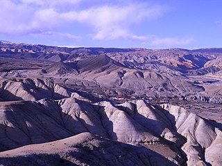
Lomanthang is a rural municipality in Mustang district in Gandaki Province of western Nepal. It is located at the northern end of the district, bordering the Tibet Autonomous Region of China to the north and Dalome rural municipality of Mustang in the south.

A Village Development Committee (VDC) in Nepal was the lower administrative part of its Ministry of Federal Affairs and Local Development. Each district had several VDCs, similar to municipalities but with greater public-government interaction and administration. There were 3,157 village development committees in Nepal. Each VDC was further divided into several wards depending on the population of the district, the average being nine wards.
Charang (Tsarang) is a village development committee in Mustang District in the Dhawalagiri Zone of northern Nepal. At the time of the 1991 Nepal census it had a population of 682 people living in 130 individual households.
Chhonhup is a village development committee in Mustang District in the Dhawalagiri Zone of northern Nepal. At the time of the 1991 Nepal census it had a population of 1047 people living in 192 individual households.

Chhoser (also known as Garphu) is a village development committee in Mustang District in the Dhawalagiri Zone of northern Nepal. At the time of the 1991 Nepal census it had a population of 728 people living in 168 individual households.

Chhusang is a village development committee in Mustang District in the Dhawalagiri Zone of northern Nepal. It is located on the Upper Mustang trekking route, between Tangbe and Chele, about an hour's walk north of Tangbe. It lies at the junction of the Narshing river and the Kali Gandaki.
Dhami, Nepal is a village development committee in Mustang District in the Dhawalagiri Zone of northern Nepal. At the time of the 1991 Nepal census it had a population of 850 people living in 158 individual households.

Jhong is a village development committee in Mustang District in the Dhawalagiri Zone of northern Nepal. At the time of the 1991 Nepal census, it had a population of 450 people living in 91 individual households.
Kunjo is a village development committee in Mustang District in the Dhawalagiri Zone of northern Nepal. At the time of the 1991 Nepal census it had a population of 668 people living in 147 individual households.

Lete is a village development committee in Mustang District in the Dhawalagiri Zone of northern Nepal. At the time of the 1991 Nepal census it had a population of 914 people living in 189 individual households. It is a scenic village surrounded by Dhawalagiri, Annapurna and Nilgiri. This village is governed by chairman the, Ama-Samuha, and other members.

Marpha is a village in Mustang District in the Dhawalagiri Zone of northern Nepal. At the time of the 1991 Nepal census it had a population of 1630 people living in 434 individual households.
Surkhang is a village development committee in Mustang District in the Dhawalagiri Zone of northern Nepal. At the time of the 1991 Nepal census it had a population of 651 people living in 130 individual households.

Tukuche, sometimes spelt Tukche, is a village development committee in Mustang District in the Dhawalagiri Zone of northern Nepal. At the time of the 1991 Nepal census it had a population of 652 people living in 166 individual households.

Bajung is a village development committee in Parbat District in the Dhawalagiri Zone of Western Development Region, Nepal. It is surrounded by Deupurkot to the north-east, Tilahar to the south-east, Durlung to the south-west and Kyang to the north-west. It is popularly said to be extended from the top of Maidan, a hill-top with historical identity to the basin of Modi River. At the time of the 2011 Nepal census it had a population of 4228 people living in 1,076 individual households.
Durlung is a market center in Kushma Municipality in Parbat District in the Dhawalagiri Zone of central Nepal. The formerly Village Development committee was annexed to form the municipality since 18 May 2014. At the time of the 1991 Nepal census it had a population of 3202 people living in 659 individual households. Durlung kot mandir is quite famous historical place. One of the king used to live there when Nepal had distributed in 22/24 state.most of the people are BRAHMINS in this VDC.
Lunkhu Deurali is a Village Development Committee in Parbat District in the Dhawalagiri Zone of central Nepal. At the time of the 2011 Nepal census it had a population of 2546 people living in 503 individual households.
Bhakunde is a village development committee in Baglung District in the Dhawalagiri Zone of central Nepal. At the time of the 1991 Nepal census it had a population of 3,833 and had 697 houses in the village. At the time of the 2011 Nepal census it had a population of 4,952 among which 2,443 were female and 2,509 were male. There were about 831 houses in the village.
Sinhadevi was a village development committee in Morang District in the Kosi Zone of south-eastern Nepal.It lies in the northern part of Morang district. Singhadevi was incorporated with a Kerabari, Yangsila, Patigaun & two wards of Bhogteni VDC and has become Kerabari rural municipality.After becoming the part of kerabari rural municipality whole sighadevi VDC has become ward no-2 of Kerabari rural municipality.At the time of the 1991 Nepal census it had a population of 2554 people living in 477 individual households.
Lo-Ghekar Damodarkunda (earlier:Dalome) is a rural municipality situated in Mustang District of Gandaki Province of Nepal. The rural municipality is situated on the northern part of the Mustang, surrounded by Lomanthang rural municipality on the north, Barhagaun Muktichhetra on the south, Manang District on the south-east and Dolpa District on the west, north-eastern border of the rural municipality touches border with Tibet of China.


