Millfield is a residential area of the city of Peterborough, Cambridgeshire in the United Kingdom. For electoral purposes it comprises the main part of Peterborough Central ward. A multicultural area, the Faidhan-e-Madina Mosque opened in nearby New England in 2003. The area has at times seen high racial tensions and disturbances, most notably in September 2001 when teenager Ross Parker was murdered by a gang of Muslims of Pakistani origin, in an unprovoked racially motivated attack.

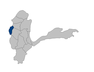
Shahri Buzurg District is one of the 28 districts of Badakhshan Province in eastern Afghanistan. The capital is the city of Shahri Buzurg. Its northwestern border is along the international border between Afghanistan and Tajikistan while its southwestern border is with Takhar Province. Located on the western edge of the province, Shahri Buzurg hosts a population of approximately 42,000 residents.
Łąki is a village in the administrative district of Gmina Milicz, within Milicz County, Lower Silesian Voivodeship, in south-western Poland. Prior to 1945 it was in Germany.

Pierwoszów is a village in the administrative district of Gmina Wisznia Mała, within Trzebnica County, Lower Silesian Voivodeship, in south-western Poland. Prior to 1945 it was in Germany.
Sverdrup Pass is a mountain pass in central Ellesmere Island, Nunavut, Canada.

Crișan is a commune in Tulcea County, Romania. It includes three villages: Caraorman (45°04′54″N29°23′20″E), Crișan (45°10′25″N29°23′26″E) and Mila 23 (45°13′43″N29°14′57″E).

Böyükbəyli is a village in the Agdam Rayon of Azerbaijan. The village forms part of the municipality of Üçoğlan.

Ruskołęka-Parcele is a village in the administrative district of Gmina Andrzejewo, within Ostrów Mazowiecka County, Masovian Voivodeship, in east-central Poland. It lies approximately 5 kilometres (3 mi) west of Andrzejewo, 17 km (11 mi) east of Ostrów Mazowiecka, and 104 km (65 mi) north-east of Warsaw.

Falęcin is a village in the administrative district of Gmina Staroźreby, within Płock County, Masovian Voivodeship, in east-central Poland. It lies approximately 11 kilometres (7 mi) east of Staroźreby, 31 km (19 mi) east of Płock, and 74 km (46 mi) north-west of Warsaw.
Kobylaki-Wólka is a village in the administrative district of Gmina Jednorożec, within Przasnysz County, Masovian Voivodeship, in east-central Poland.

Zalesie is a village in the administrative district of Gmina Skaryszew, within Radom County, Masovian Voivodeship, in east-central Poland. It lies approximately 7 kilometres (4 mi) south of Skaryszew, 19 km (12 mi) south-east of Radom, and 110 km (68 mi) south of Warsaw.

Popielarze is a village in the administrative district of Gmina Radzymin, within Wołomin County, Masovian Voivodeship, in east-central Poland. It lies approximately 11 kilometres (7 mi) north of Radzymin, 19 km (12 mi) north of Wołomin, and 34 km (21 mi) north of Warsaw.
Dębina is a settlement in the administrative district of Gmina Wągrowiec, within Wągrowiec County, Greater Poland Voivodeship, in west-central Poland.

Nowa Jasionka is a former settlement in the administrative district of Gmina Kołczygłowy, within Bytów County, Pomeranian Voivodeship, in northern Poland. It lies approximately 11 kilometres (7 mi) south of Kołczygłowy, 17 km (11 mi) west of Bytów, and 94 km (58 mi) west of the regional capital Gdańsk.

Żmijewo is a village in the administrative district of Gmina Kolbudy, within Gdańsk County, Pomeranian Voivodeship, in northern Poland. It lies approximately 4 kilometres (2 mi) south-east of Kolbudy, 8 km (5 mi) west of Pruszcz Gdański, and 16 km (10 mi) south-west of the regional capital Gdańsk.

Kościerska Huta is a village in the administrative district of Gmina Kościerzyna, within Kościerzyna County, Pomeranian Voivodeship, in northern Poland. It lies approximately 3 kilometres (2 mi) north-east of Kościerzyna and 49 km (30 mi) south-west of the regional capital Gdańsk.

Czechowo is a village in the administrative district of Gmina Elbląg, within Elbląg County, Warmian-Masurian Voivodeship, in northern Poland. It lies approximately 8 kilometres (5 mi) north-east of Elbląg and 77 km (48 mi) north-west of the regional capital Olsztyn.

Wilkowo Wielkie is a village in the administrative district of Gmina Barciany, within Kętrzyn County, Warmian-Masurian Voivodeship, in northern Poland, close to the border with the Kaliningrad Oblast of Russia. It lies approximately 7 kilometres (4 mi) west of Barciany, 17 km (11 mi) north-west of Kętrzyn, and 68 km (42 mi) north-east of the regional capital Olsztyn.
Maijirgiu is a village and rural commune in Niger.

Krasiński Square is a square in the central district of Warsaw, Poland. The square itself is adjacent to Warsaw Old Town and features buildings of great historical and national significance.


