Mount Richard Bennett is a 3,190 m (10,466 ft) peak located at co-ordinates 52°49′48″N119°47′36″W in the Premier Range of the Cariboo Mountains in the east-central interior of British Columbia, Canada. The mountain is just north of the taller Mount Sir John Abbott and is often considered a continuation of that mountain.
Beerschoten is a hamlet in the municipality Utrechtse Heuvelrug, in the Dutch province Utrecht.
Romanowo is a village in the administrative district of Gmina Koneck, within Aleksandrów County, Kuyavian-Pomeranian Voivodeship, in north-central Poland.

Raciąż-Piaski is a village in the administrative district of Gmina Tuchola, within Tuchola County, Kuyavian-Pomeranian Voivodeship, in north-central Poland. It lies approximately 9 kilometres (6 mi) north-west of Tuchola and 63 km (39 mi) north of Bydgoszcz.
Florkowizna is a village in the administrative district of Gmina Chodecz, within Włocławek County, Kuyavian-Pomeranian Voivodeship, in north-central Poland.
Chomińszczyzna is a village in the administrative district of Gmina Narewka, within Hajnówka County, Podlaskie Voivodeship, in north-eastern Poland, close to the border with Belarus.
Sadowa is a village in the administrative district of Gmina Brzeziny, within Brzeziny County, Łódź Voivodeship, in central Poland. It lies approximately 4 kilometres (2 mi) east of Brzeziny and 24 km (15 mi) east of the regional capital Łódź.
Orzeszków is a village in the administrative district of Gmina Uniejów, within Poddębice County, Łódź Voivodeship, in central Poland. It lies approximately 6 kilometres (4 mi) north of Uniejów, 19 km (12 mi) north-west of Poddębice, and 54 km (34 mi) north-west of the regional capital Łódź.
Jakimowice is a village in the administrative district of Gmina Radoszyce, within Końskie County, Świętokrzyskie Voivodeship, in south-central Poland. It lies approximately 5 kilometres (3 mi) west of Radoszyce, 22 km (14 mi) south-west of Końskie, and 36 km (22 mi) north-west of the regional capital Kielce.
Gołębiów is a village in the administrative district of Gmina Jasieniec, within Grójec County, Masovian Voivodeship, in east-central Poland. It lies approximately 15 kilometres (9 mi) east of Grójec and 44 km (27 mi) south of Warsaw.
Helenów is a village in the administrative district of Gmina Wodynie, within Siedlce County, Masovian Voivodeship, in east-central Poland. It lies approximately 7 kilometres (4 mi) east of Wodynie, 21 km (13 mi) south-west of Siedlce, and 76 km (47 mi) east of Warsaw.
Wilkowo Polskie is a village in the administrative district of Gmina Wielichowo, within Grodzisk Wielkopolski County, Greater Poland Voivodeship, in west-central Poland. It lies approximately 9 kilometres (6 mi) south-east of Wielichowo, 20 km (12 mi) south of Grodzisk Wielkopolski, and 50 km (31 mi) south-west of the regional capital Poznań.
Żółków is a village in the administrative district of Gmina Żerków, within Jarocin County, Greater Poland Voivodeship, in west-central Poland. It lies approximately 2 kilometres (1 mi) east of Żerków, 13 km (8 mi) north-east of Jarocin, and 60 km (37 mi) south-east of the regional capital Poznań.
Leszczyca is a village in the administrative district of Gmina Gizałki, within Pleszew County, Greater Poland Voivodeship, in west-central Poland.
Bieleń is a village in the administrative district of Gmina Trzciel, within Międzyrzecz County, Lubusz Voivodeship, in western Poland.
Nawty is a village in the administrative district of Gmina Godkowo, within Elbląg County, Warmian-Masurian Voivodeship, in northern Poland. It lies approximately 31 kilometres (19 mi) east of Elbląg and 52 km (32 mi) north-west of the regional capital Olsztyn.

Břežany II is a village and municipality in Kolín District in the Central Bohemian Region of the Czech Republic.

Ifernouane is a village and rural commune in Niger. As of 2011, the commune had a total population of 13,243 people.
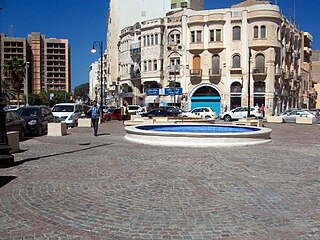
Maydan al-Shajara, is a major town square in Benghazi, the second largest city in Libya. A large native Atlas Cedar tree was located in the center of the square, giving it its name. The square is located in the center of Benghazi, linking two primary roads, Gamal Abdel al-Nasser Street and 'Amr ibn al-'As Street.

Mersin Orthodox Church is a church in Mersin, Turkey.


