
Bongaigaon district (Prpn:ˈbɒŋgaɪˌgãʊ) is an administrative district in the state of Assam in northeastern India. The district headquarters are located at Bongaigaon. The district occupies an area of 1,093 km2.

The Dooars or Duars are the alluvial floodplains in eastern-northeastern India and southern Bhutan that lie south of the outer foothills of the Himalayas and north of the Brahmaputra River basin. This region is about 30 km (19 mi) wide and stretches over about 350 km (220 mi) from the Teesta River in West Bengal to the Dhansiri River in Udalguri district of Assam. The region forms the gateway to Bhutan. It is part of the Terai-Duar savanna and grasslands ecoregion.

Dhubri is a town and the administrative centre of Dhubri district in the Indian state of Assam. It is an old town on the bank of the Brahmaputra river, with historical significance. In 1883, the town was first constituted as a Municipal Board under the British regime. It is situated about 277.4 kilometres (172 mi) west from Dispur, the state capital of Assam.
Goalpara ) is the district headquarters of Goalpara district, Assam, India. It is situated 134 kilometres (83 mi) to the west of Guwahati.
Goalpariya is a group of Indo-Aryan dialects spoken in the Goalpara region of Assam, India. Along with Kamrupi, they form the western group of Assamese dialects. The North Bengali dialect is situated to its west, amidst a number of Tibeto-Burman speech communities. The basic characteristic of the Goalpariya is that it is a composite one into which words of different concerns and regions have been amalgamated. Deshi people speak this language and there are around 20 lakhs people.
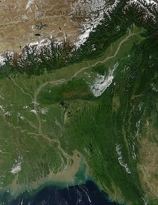
The Brahmaputra Valley is a region situated between hill ranges of the eastern and northeastern Himalayan range in Eastern India.

The state of Assam in India has five regional divisions, each comprising a number of districts. The person responsible for the administration of a division is designated as a Divisional Commissioner.

Upper Assam is an administrative division of the state of Assam comprising the undivided Lakhimpur and Sivasagar districts, of the upper reaches of the Brahmaputra valley. The other divisions are: Lower Assam, North Assam and Hills and Barak Valley. The division is under the jurisdiction of a Commissioner, stationed at Jorhat.
Dudhnoi is a town in Goalpara district, Assam, India.
Goalpara College is an institution of higher learning in western Assam, India. It was established in 1955 with the help and cooperation from local people. At present, it has 16 departments with a total staff strength of 110. It is affiliated to Gauhati University, Guwahati.

Naranarayan Setu (Assamese: নৰনাৰায়ণ সেতু) (IPA - nərəˈna:ra:jənə ˈseɪtu:) is the third bridge to have been constructed over the Brahmaputra River in Assam, India. It is a double-deck bridge with a railway track on the lower deck and a road on the upper deck. It has a length of 2.284 kilometres and connects Jogighopa, a town of Bongaigaon District on the north with Pancharatna, a town of Goalpara District on the south. The bridge was inaugurated on 15 April 1998 by Atal Bihari Vajpayee, the Prime Minister of India at that time. Construction was carried out by the consortium of The Braithwaite Burn and Jessop Construction Company Limited(BBJ). The approximate cost of construction of this bridge is Rs. 301 crore. This bridge is located on route of National Highway 17, erstwhile route NH-37.
Rabha is a Sino-Tibetan language of Northeast India. The two dialects, Maituri and Rongdani, are divergent enough to cause problems in communication. According to U.V. Joseph, there are three dialects, viz. Róngdani or Róngdania, Mayturi or Mayturia and Songga or Kocha. Joseph writes that "the Kocha dialect, spoken along the northern bank of the Brahmaputra, is highly divergent and is not intelligible to a Róngdani or Mayturi speaker". Joseph also writes that "[t]he dialect variations between Róngdani and Mayturi, both of which are spoken on the southern bank of the Brahmaputra, in the Goalpara district of Assam and belong to the northern slopes of Meghalaya, are minimal". He concludes the paragraph on dialectal variation with: "The Róngdani-Mayturi dialectal differences become gradually more marked as one moves further west".
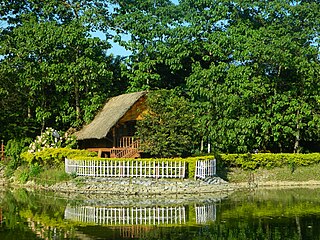
Goalpara region, largely congruous to the historical undivided Goalpara district, is a region that is associated with the people and culture of Goalpara. It is bounded on the north by Bhutan, on the east by the Kamrup region, in the south by Meghalaya and in the west by Cooch Behar and Jalpaiguri in West Bengal and Rangpur in Bangladesh. The natural landmarks are: Sankosh and Brahmaputra rivers on the west, the Manas river on the east in the north bank, and a corresponding region in the south bank; the Garo Hills in the south and Bhutan Hills in the north.
The Regions of Assam are non-administrative units in the Indian state of Assam with a common historical past. Not all these regions are mutually exclusive.

The Undivided Goalpara district is an erstwhile district of Assam, India, first constituted by the British rulers of Colonial Assam.
Assam – 16th largest, 15th most populous and 26th most literate state of the 28 states of the democratic Republic of India. Assam is at 14th position in life expectancy and 8th in female-to-male sex ratio. Assam is the 21st most media exposed states in India. The Economy of Assam is largely agriculture based with 69% of the population engaged in it. Growth rate of Assam's income has not kept pace with that of India's during the Post-British Era; differences increased rapidly since the 1970s. While the Indian economy grew at 6 percent per annum over the period of 1981 to 2000, the same of Assam's grew only by 3.3 percent.
The Mornoi River is a tributary of the Brahmaputra River in the Indian state of Assam. The Mornoi river originates at Matia village of Goalpara district. The Krishnai River meets Dudhnoi River at Matia village and then flows as Mornoi river before its confluence with the Brahmaputra River.
The Brahmaputra floods refers to a catastrophic flood event that occurred in 2012 along the Brahmaputra River and its tributaries, as well as in subsequent years.

The Dudhnoi River is a sub-tributary of the Brahmaputra River in the Indian state of Assam. The Dudhnoi River originates in the East Garo Hills of Meghalaya. The Dudhnoi River meets Krishnai River at Matia of Goalpara district and then flows as Mornoi River before its confluence with the Brahmaputra River. Floods in Goalpara district is dictated by the Dudhnoi river.

