Gallery
 Hartmanns pier by Gravaneparken
 The boardwalk in Gravaneparken
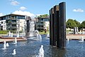 In Otterdal Park at the waterfront is the second largest fountain construction in Norway by Kjell Nupen.
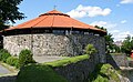 The waterfront park passes Tresse (Retranchementet) and Christiansholm Fortress.
 Statue of Camilla Collett
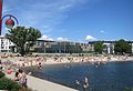 Bystranda, the beach not far south of the boardwalk


